Black Hills National Forest
Location: Sundance, Wyoming/USA
Elevation: 3,100 ft
Prominence: 1200 ft
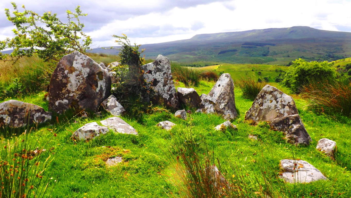
Note: Before you begin reading I already know what you’re thinking: “What could possibly be exciting about Wyoming? (yawn)” It’s a fair question, and something that should be addressed straight-away. The answer might surprise you a little. The truth is, the answer is totally related to what kind of hiker you are, and somewhat philosophical. You have to ask yourself: “Am I a trailblazing, stone-kicking, seeker of sacred zones in the misty heights?” “A geared-up ‘earthbound-astronaut-in-boots’ made for 10,000 feet above sea-level?” “Am I wading waist-deep in the Irish-muck to get to the distant hill where the Dolmen sits?” “Am I willing to go to that way-out-there place which others dismiss as too inconvenient?” In other words, are you passionate about breaking the domesticated spell of post-modern life? Or…are you the needy type? Do you need attention and noise? Are you in the habit of speaking constantly, needing to hear about this, that, and the other thing from the social-media feed? Do you need lots of stuff at your disposal? Do you need to be close to a metropolis and all its accoutrements? Do you need a constant phone/computer signal? If so, you’re not alone; but let’s put distant, hard to reach, places into perspective;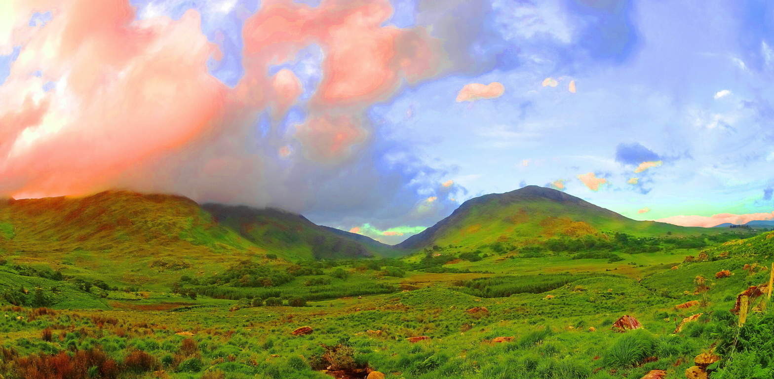 If, for example, you were to show up in a place like Killarney Ireland (Image/Left) with this needy attitude, a Killarney which is a darkly magical, mostly wet, Celtic wilderness of eternal greenery, you could perhaps say the same needy things you say of Wyoming, like: “Oh man, it’s just farms and mountains without a soul in sight”… etc etc etc. And with this needy attitude you will have already failed. You might as well go on a cruise and do the thing where you get off the boat, and then back on, after looking at a mountain from the beach, for about ten minutes. Awful. The point is this: the only real difference between the stellar beauty of a romantic wilderness like Killarney, and the lessor known wilderness of The Black Hills (Image/Below), is only the basics of fauna of the landscapes, and that’s it.
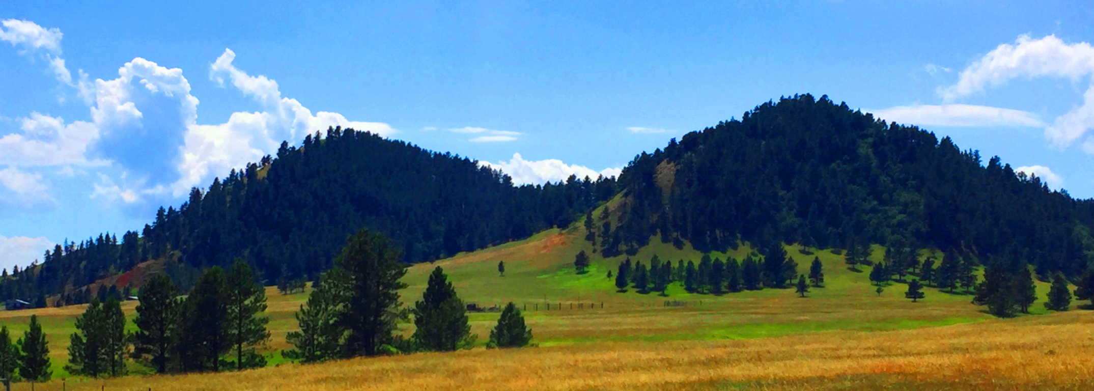 That’s all. The potential for wonder and exploration is just as possible in Wyoming as it is anywhere else on Earth. Both are haunting and spacious, eccentrically-far from any city, and soooo quiet that they are equally capable of making you face that illusive, money-bound, noise factory, you currently know as…. yourself. The Black Hills in Wyoming is yet another dream-scape that can heal your senses and sooth your thoughts. There are romantic signs in the mountains of a history that goes right back to the primordial beginning of Time, just like Celtic sites. If you open your eyes in this way, Black Hills Wyoming is a vast mystical zone, just waiting to embrace you.
 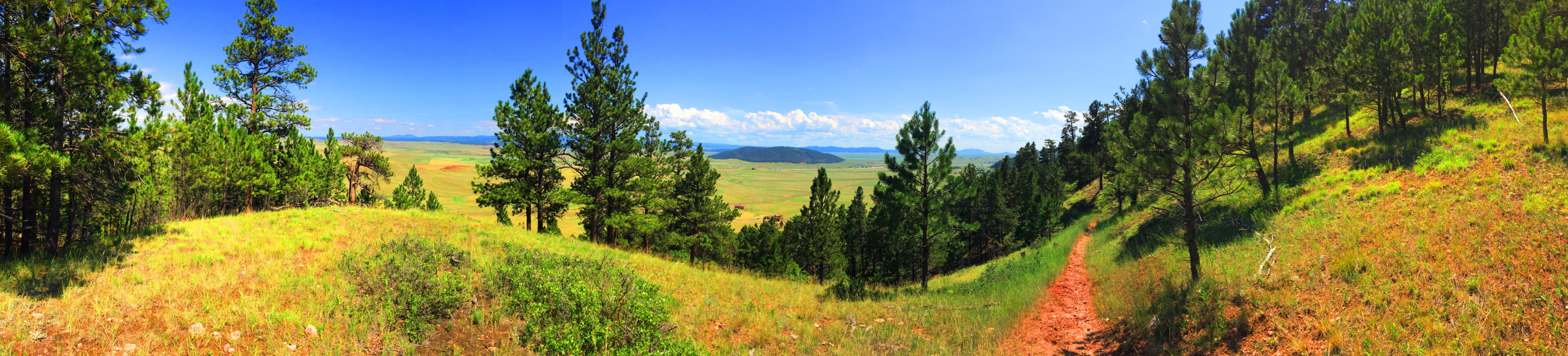 In American modern cinema, in films such as ‘Dances With Wolves’, ‘The Last of The Mohicans”, or “The Revanent”, there is an image of the “spiritually in-tune” Native American. This image of the stoic, quiet minded, spiritually animated native, is not easily grasped by the domesticated culture we now find ourselves in, where almost 65% of the population has now been forced to inhabit cities. It is hard to comprehend the once spiritual state of the Native American in such a postmodern situation. But, if cities are the mechanism for our domestication, than places like Black Hills National Forest in Wyoming, are the mechanism for cosmic-quiet, and a confident solitude that the Native Americans once knew. When you enter them, the quiet is practically a persona to be interacted with, not just a lack of meaningless bustle and monotonous motion. You can truly realize this in this absolutely vast space, and slightly hypnotizing slopes of the Black Hills.
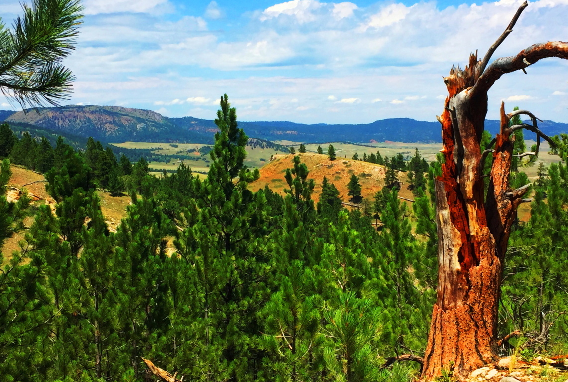
Even the image of this wide-open landscape can’t do the actual scale justice. South of this place, the Wyoming Plain rolls like an intermediary dimension between Heaven and Hell, neither rising nor falling, just continuing into an ever distant blue horizon. Some History: Obviously no Roman Army ever traversed this place, like in England or France, although, I have to think that the Caesars would have been tempted by the idea of crossing such a vast stretch of accessible land, like when they penetrated the high Plains of Scotland, where they were eventually turned back by the Picti (Scottish Natives). So, who did walk in this place in Wyoming? The Arapaho, Cheyenne, Ute, and Shoshone all inhabited this vast space as warrior-hunters of the Plains. We now know that most of their ancestors wandered over the land-bridge while hunting animals from the East-Eurasian Continent to what is now Alaska, created by the receding Ice-Age some 40,000 years ago. Once upon a time, this Plain was inundated with Buffalo, an animal by which nearly every human need can be resourced. The native tribes, amazingly, say that they were NOT the first to inhabit this place, but rather, the ancient myths tell of a race of “Celtic looking (caucasion) red-haired giants” who were already here when the natives arrived. Strangely enough, the Native Israelite tribes encountered the exact same thing when they entered Israel from Arabia, discovering giants in the hills, which is recorded in Semetic Scripture: ‘Numbers 13:32’. The Mayan and Inca say the very same thing. The megaliths of South America were there BEFORE THEY ARRIVED. In fact, nearly every Native American tribe has stories of giants controlling the heights of the mountains and hills. And these are the oldest stories that the tribes have to offer, which are now faded into inaccuracy and mere myth, due to the genocide that came for the natives in the modern Era. Like the native Scottish Picti tribes, these Native Americans were at-one with the landscape, and also like the Picti, when a foreign army came marching through, they decided to paint themselves for battle, and fight. Of-course it wasn’t the Roman Army which wandered into the heights of Wyoming, but The Union Army, a far more advanced and devastating force, and we know how that story ends. Don’t let this wide-open space and silence fool you; although it is profoundly peaceful there are mysteries and epic events which took place here, making it that much more haunting in the heights of the trail. The natives called this place “The Black Hills”, although I am not entirely sure how they could have…
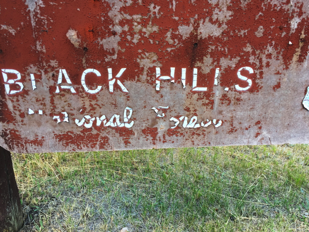 The scene is a dry green and golden haze that embeds striking patches of massive trees and knolls. It all booms-out over the region as if it never ends. The trails are not what you would call ‘a going concern’, but are still marked by the classic cursive lettering and soil-brown signs that were erected at the turn of the century. I’ve waited my entire life to see one of these particular types of signs; seeing one means you’re in the Great North West of America; a rock-star zone for hikers. This is the listed trail-head for the Black Hills, down a lulling farm-road, about 7 miles from the classically Americana town of Sundance Wyoming, population 1,182. Sundance has veterans who died for the United States memorialized in the center of Town, along with home-like breakfast parlors and ice-cream shops straight out of a Norman Rockwell painting. But these people aren’t lost to the Times, as you might ignorantly assume; they are a deeply rustic, tough, and caring people who look you straight in the eye, and extend a helping hand in a moments notice.
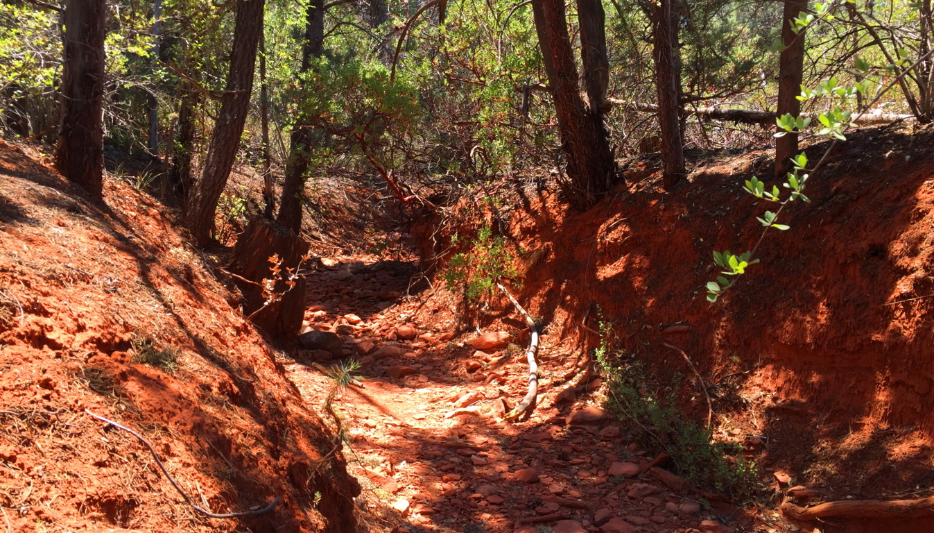
 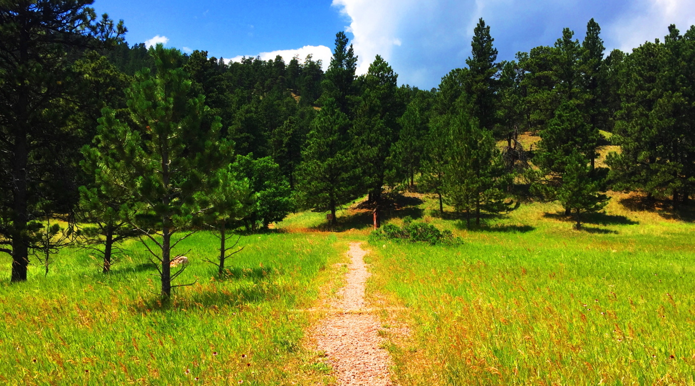 Black Hills Trail: Entering this trail is as pleasant as it gets. There are distinct and clear heights in front of you, with a breeze and swaying grass beneath spaciously assorted Pines.
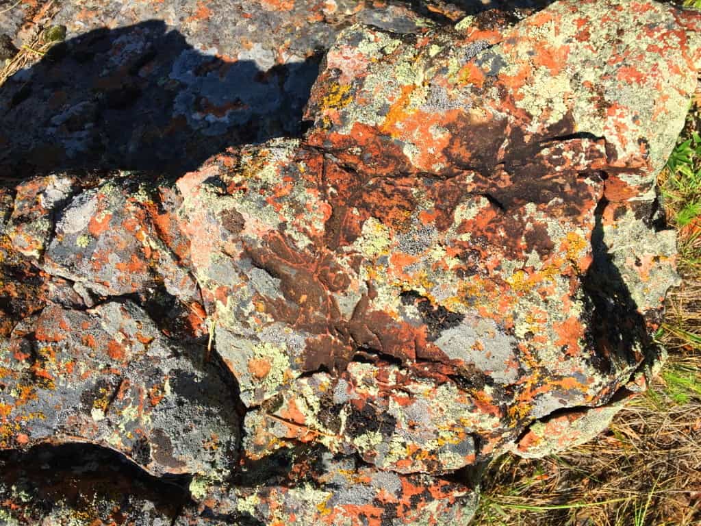
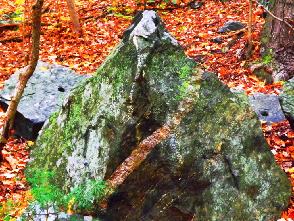
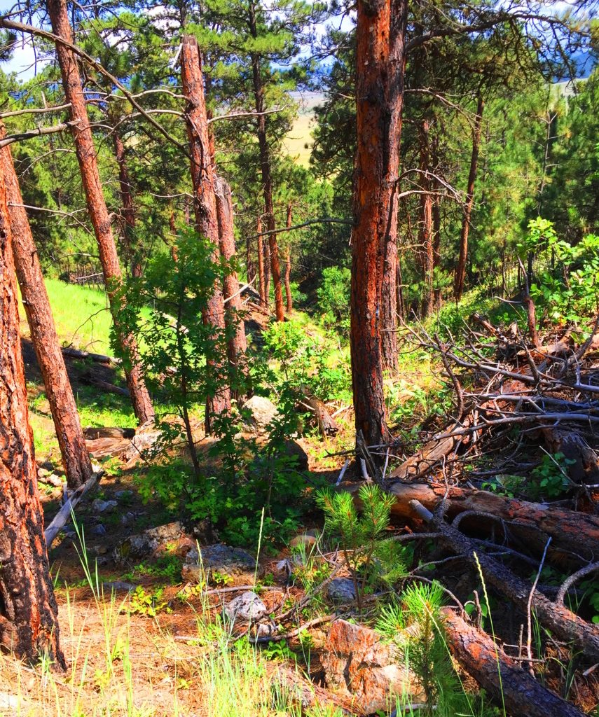 The path appears to be a modern work of Cub Scouts and campers from the last 100 years. There are no signs of the ancient stony paths found in Celtic heights, New England, or northern Colorado. The one factor that is entirely unique to this space is the level of quiet, if that is possible to measure. It is simply a denser quiet. Even the regular sounds of hawks or wild goats are not heard in these hills. It will make you more aware of yourself in return. Often times it’s a moment to say to yourself: “Well, at least I’m not in my office/in traffic/on-line/ etc etc etc. The Trail switches back a few times as you ascend a solid soil pathway through the Ponderosa treeline (Image/Left). As the hillside reveals itself, there are stones that begin to pop up, of a type I had never seen before. As the trail levels off near the top of the initial knoll, it begins to veer into the deeper woods, and boulders akin to what is found on the ledges of New England, begin appear. I have to admit that the ledges and boulders here were so ancient looking, so old, that I realized I had never seen this specific type before. Ancient Wyoming boulders are practically rust colored with orange and brown spots. (Image/Below/Right) This is very similar to the pattern on Alpine stones found in the heights of Mount Katahdin (Below/Left). Look at the Same rare spotted pattern, although they are very different colors.
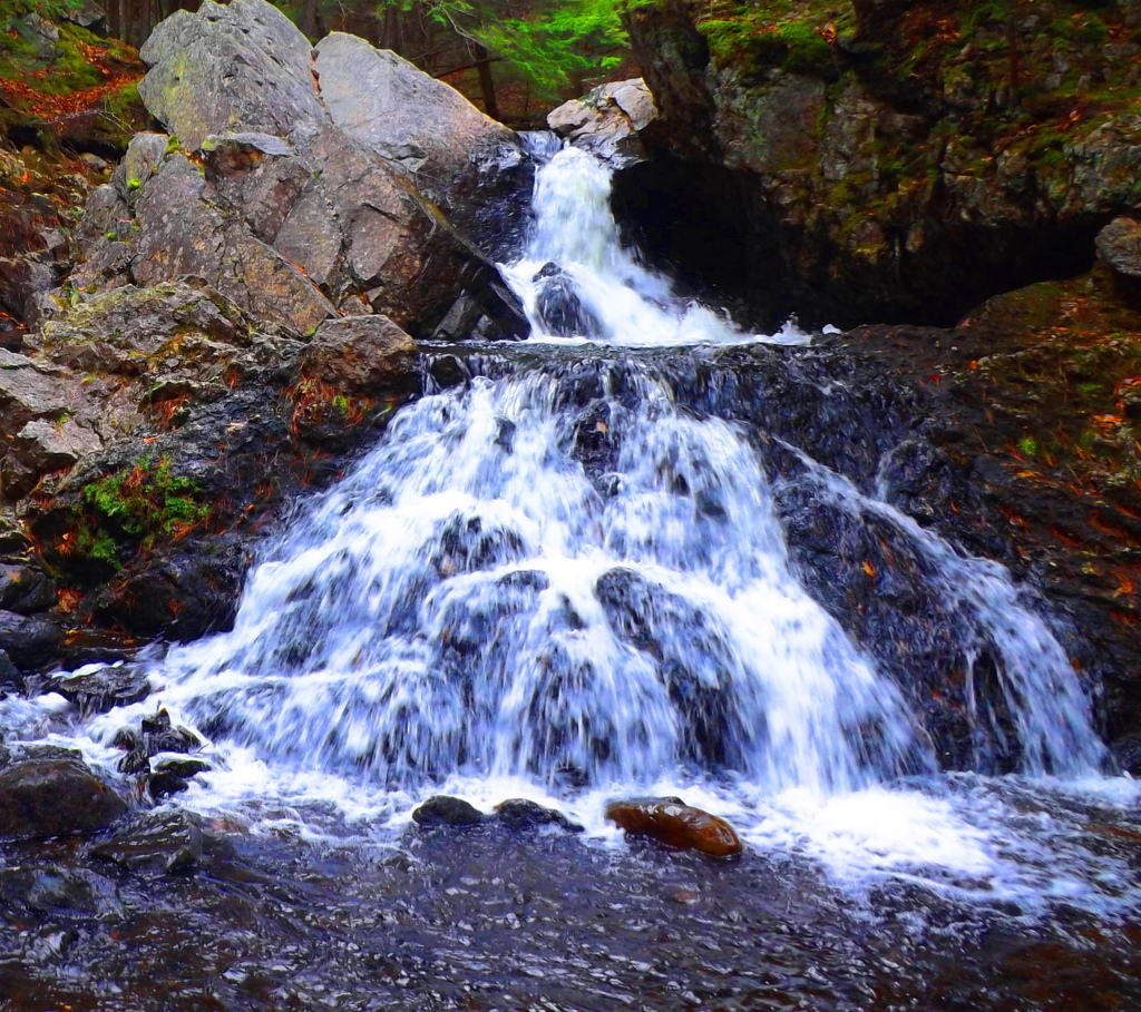
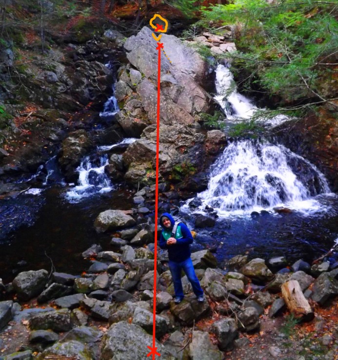
 There are also boulders in auspicious vantage points throughout the early portion of the upper trail.(Image/Below) You can see cut-sections of ancient hillside stone, with a free standing boulder on the upper left corner in the image, in an advantageous vantage-point above, just like on New England ledges. Whoever put these boulders there are the first occupants of this land, before the Native Americans arrived.
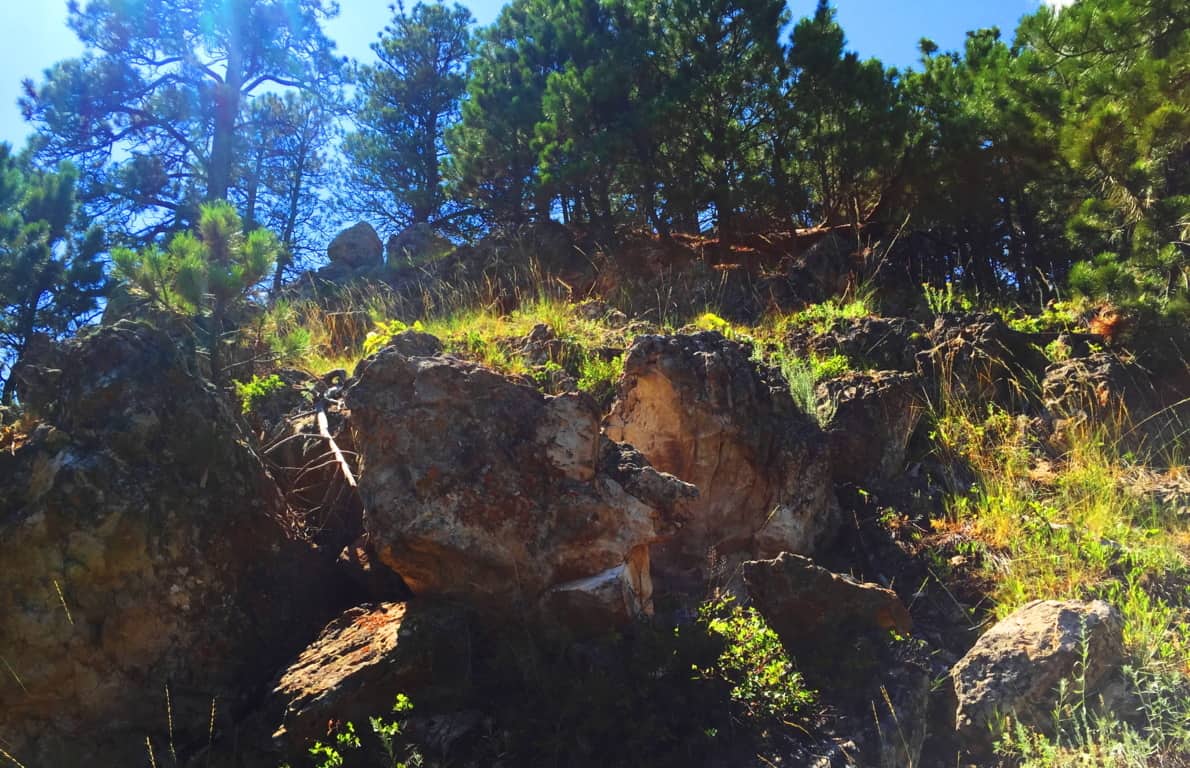 The places where the stones are cut, and stacked, on top of each other are most often the most beautiful views facing outward, not hidden in the forest. Again, this is so similar to Ireland and New England that it is nearly impossible to ignore. Look how distinctly the stone is cut and set in a fixture in the image below.
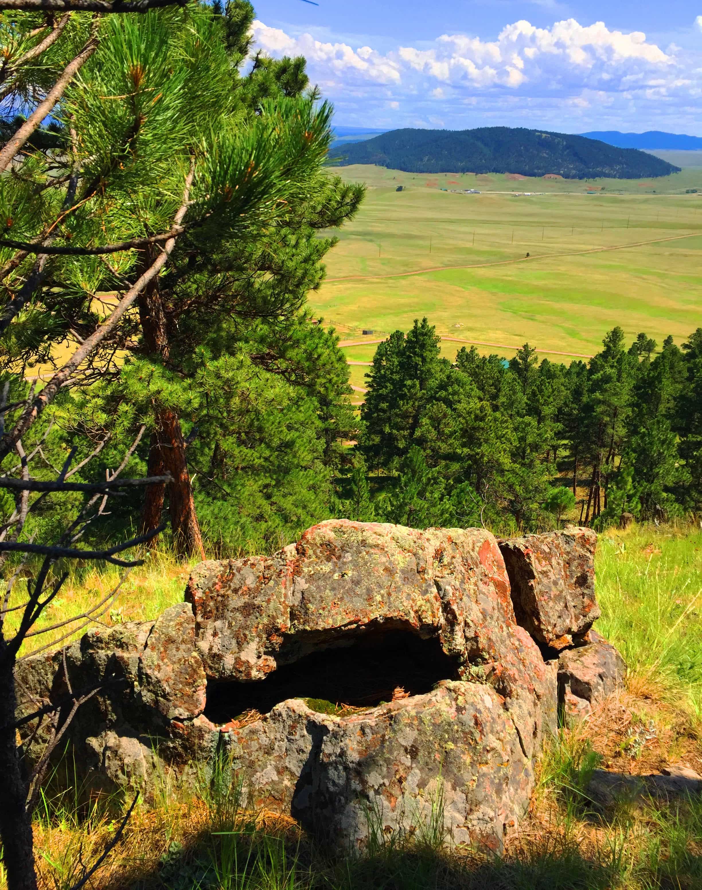 The second third of the trail, the upper trail, becomes gorgeous forest. This is a beautiful stretch of trees and thickets, and there is a temptation to wander into it, leaving the path behind. I don’t recommend going off-trail on a first excursion, but with time, and more knowledge of the range, it might be possible some day in the future.
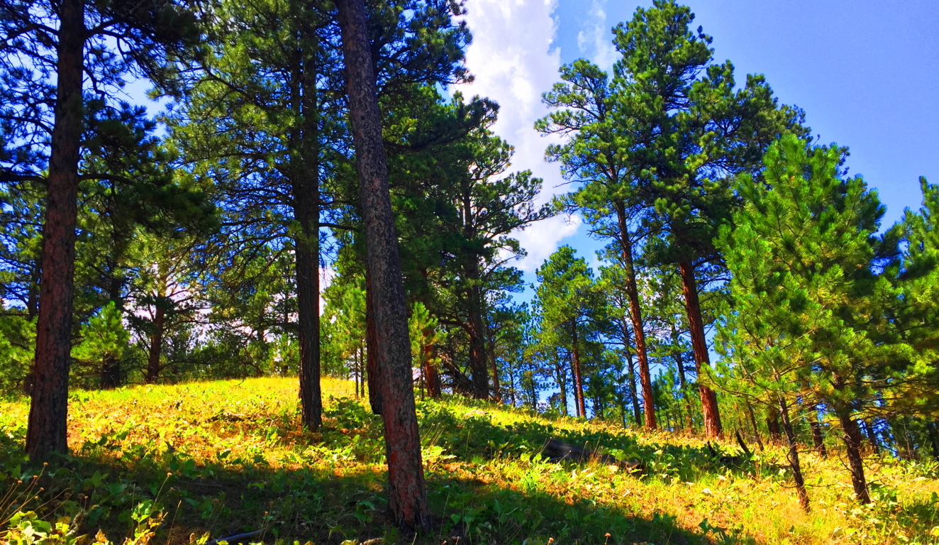
The upper vale in any range, whether it’s the White Mountains of Vermont, or The Berkshires of New York, are almost always a type of secondary dimension. You step through them, only to have them change as you go. Your perspective can change from ‘surrounded by pillars of reddish brown’ to ‘sifting through small shafts of milky-white limbs’; i.e: Ponderosa’s to Birch’s. This might be hard for a hiking layman to understand, but a particular grove can change the way you feel. The Ponderosa Pine grove (Image/Above) is a distinctly different feeling than the Birch grove (Image/Below). Harder still it is to comprehend for many beginners, is that forests, in this manner, teach us about our level of receptivity and perception. Imagine what happen if you chance to walk through 50 forests, or 100, in this lifetime. 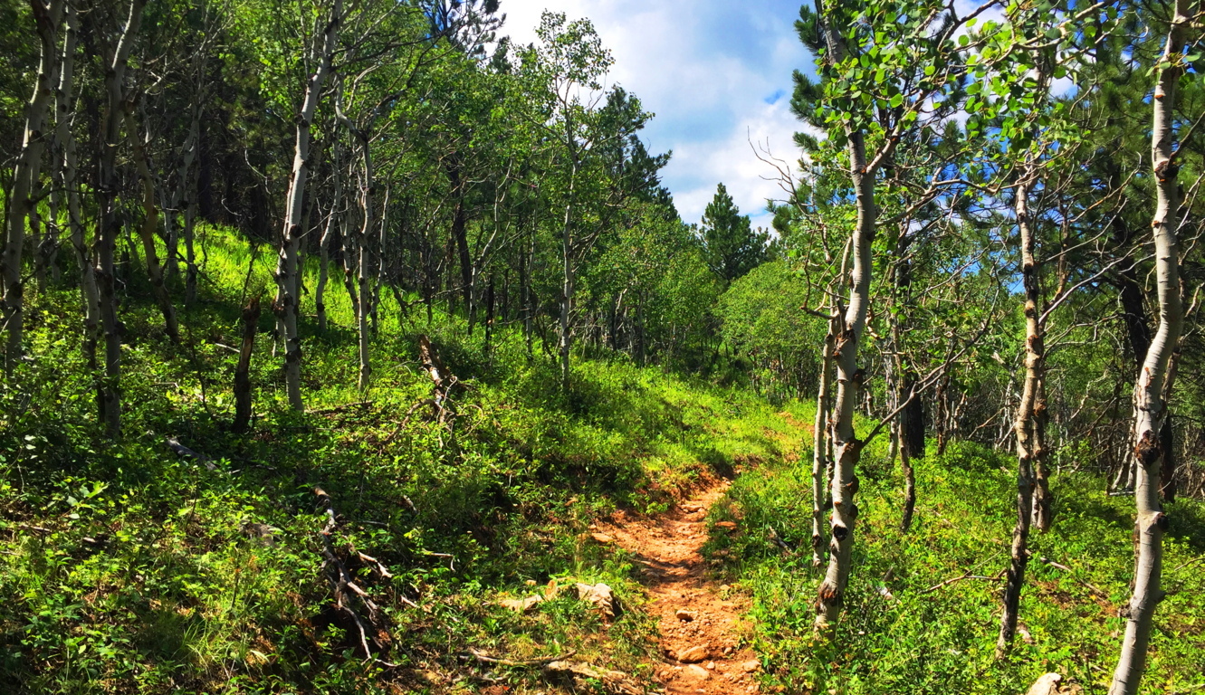 On the higher end of that receptivity is realizing and experiencing sacred zones. They feel beyond Time. Places where megaliths are found are almost always in accordance with this mystical feeling, and we are discovering through dynamic new anthropology that this is anything but wishful thinking. There are entire forests and ranges in New England and Ireland that have connective engineering throughout the entire landscape (See Cavan Burren National Park/Stonestrider.com). The landscape is literally stone-grafted to synergize the experience of moving through it. Most people, even in this age, just can’t get their minds around the idea that the entire landscape is a temple or monument, harnessing very real subtle energies. This particular trail in Wyoming is a chance to see the contrast between landscapes that are inundated with stone-linings, and those that are not, and what that might mean. Why is there not a single stone-lining in these beautiful small-mountains, while in New England there are enough Stone-linings to circle the Earth several times over? What does it mean?
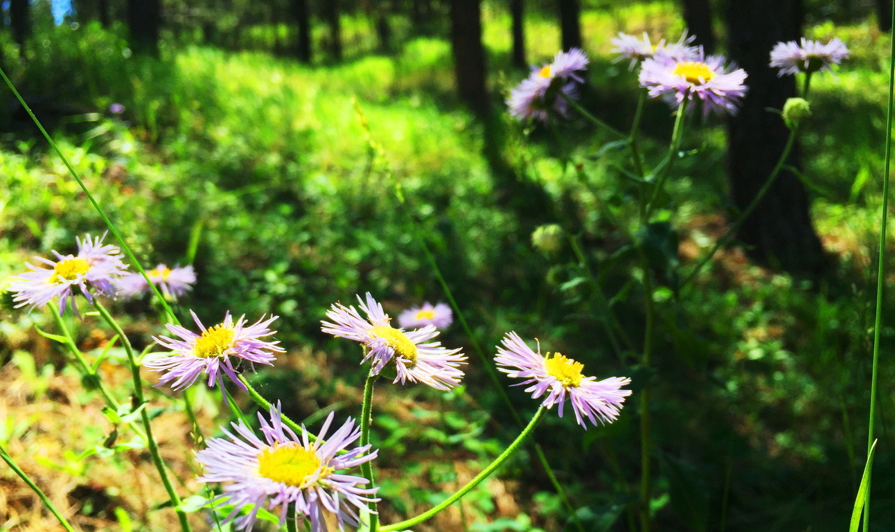
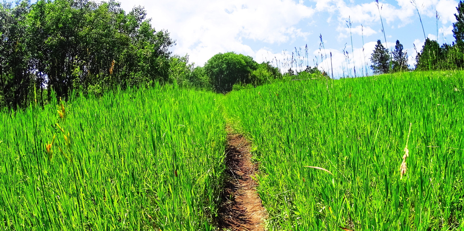 The trail here at Black Hills opens up into elevated fields of thriving grass beds within the glades, with absolutely no stone distinctions. You can almost picture an Arapaho Native materializing out of the woods, with nothing particular on his mind in this absolute tranquility. Prairie Asters emerge along the path, as well as what looks like a lavender Lonicera type flower. Entire fields of these wildflowers appeared across the next range, several miles from this spot, and everything about these beds indicates a vibrant, happy, and healthy zone.

The cover photo of this article, at the very top of the page, looks to be the objective of this Black Hills Trail. It’s a fine view across the valley. This is a place to sit down for a while. Impressively, the trail doesn’t loop back, it continues rolling on through several small Ranges to the north, perhaps as much as another ten miles after this 2.5 mile section.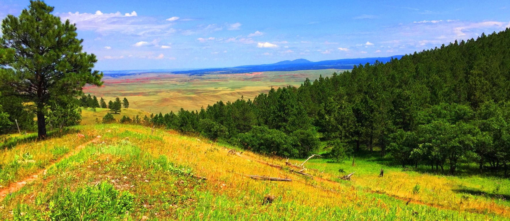
To exit the Trail, simply head back the way you came, and enjoy each ridge and the views they offer as you go.
There are places that are more intrinsically natural than others. Everything about Wyoming says “Don’t worry.” The Black Hills is a Trail that forces you to wonder how many of your problems are self induced. The peace in a place like this is so stunning that there is a cleansing of any spirit that passes through it, like a “landlocked baptism.” Landscapes don’t always have to reveal specific megalithic statements to be sacred. The land itself is at the heart of the ability to feel the sacred. It is entirely possible to see and feel the calm that the Native Americans felt for thousands upon thousands of years, and there are still ancient echoes of what was here before, written in the stone ridges. In a contentious time like this, Black Hills Trail is pure medicine, a regenerating tranquility that can take any modern confusion that you might have, and massage it into a cosmic calm so abundantly represented in the hills of Wyoming. Those who ignorantly accuse places like this of being “boring” are already drowning in a technological pool of hyper-urbanized poison. Wyoming is gorgeous, peaceful, mysterious, and gracious, with each and every step, and each step you take through it, is a step closer to your better-self. Black Hills Wyoming is part of the answer in this world, not a source of division; what more do you need to hear? Explore our world, and leave those that are trying to control and monitor every move you make, far, far, behind. Thanks for reading Stonestrider.com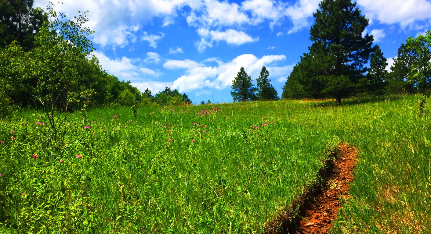
Red Rocks National Park

Location: Sedona/Arizona/USA
Elevation: 3,900 ft
Note: Welcome to the place in every persons imagination where ‘epic Quests’ take place. This is the ‘impossible wasteland’ of mythic tales, like Don Quixote, or The Song of Roland. This is the backdrop that provides ultimate silhouettes, and inexplicable skylines. Colors radiate from both the sky and stones, and these stones are nothing less than solid-rock skyscrapers. People come here to turn monumental pages in their lives, and to leave the East behind. 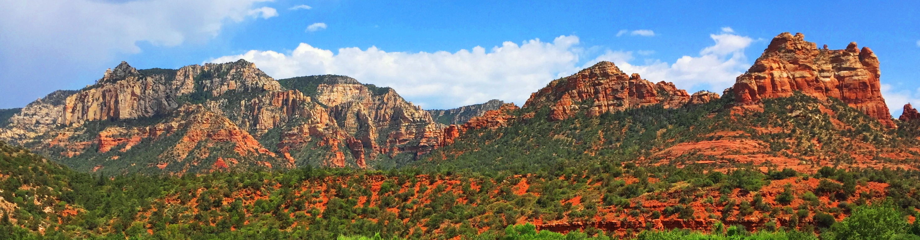 Nearly every conversation from the local people, from artists and hikers alike, includes the idea that Sedona changes lives. The trails at Red Rocks National Park, where Sedona is located, feels like the natural stage for the places in which Jesus preached, or The Crusades. Precious waterways roll beneath tunnels of reeds, cutting through a universe of rock, looking like miniatures of The River Jordan. The river is actually Oak Creek, which is also the name for the main trail leading from the visitors center. (Image/Below)
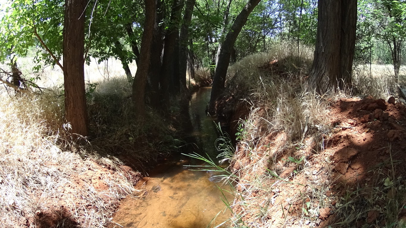 Their are just so many associations that are possible in one glance, that all you can really do is catch your breath…
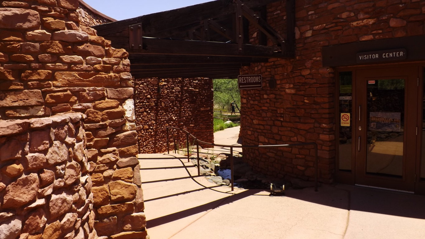
………………………………………………………………………………………………………………………………………………………………………………………………………..

Myths: Native to this landscape are the Anasazi, a people that carved their dwellings out of the highest livable portions of the upper canyons, as well as concealed rock dwellings on the Plain. The upper Anasazi dwellings are so elevated that they can only be reached by rope. Why would an entire culture build homes so high above their essential resources? What was roaming the plain that required a great height to steer clear from? Interestingly enough, the Anasazi myths, just like the Celtic ones, are of Giants.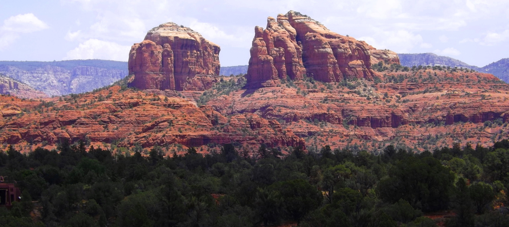 Why do all the oldest cultures insist that they experienced Giants? Something to think about, and this is the place to do it. As it is with so many places in the American West, there is a toughness to everything you see, but even with that toughness, a delicate beauty refuses to be ignored, which can be seen in the color of the wildflowers at Oak Creek Trail.
Oak Creek Trail: Red Rocks’ is sprawled-out massively to the east of Sedona. Oak Creek Trail is the best introductory experience here, with about five miles of options that head into ridges where photos can be beautifully made. You cross the Oak Creek Bridge and wander into a rare reality. The amazing thing here, in 105 degrees of heat in July, is that the fauna finds a way, and colorful statements emerge in the landscape. (Image/Below)
After crossing the bridge and heading up a few of the ridges you can turn north and see this epic space. There are hills and rock towers, forests and grand ridges, with miniature canyons, all in one glance.
  The concentrated ridges truly look like temples. Perhaps that is why one of the more major statements in the park is called Cathedral Rock.
Cathedral Rock Trail: Cathedral Rock’ has its own trailhead, but can be reached by a 8 mile trail from the Oak Creek route. This longer route required preparation and expertise. Any trail passing through the High Plain will require 1.5 gallons of water and food in your pack, along with a small med kit. Respect this wilderness. From the trailhead at Cathedral Rock, which can be reached by a simple and brief car ride, there is a fantastic loop that takes you around the ‘Cathedral’. There is a type of reverence here, with the Cathedral in sight, as if something otherworldly once happened at this beautiful place. 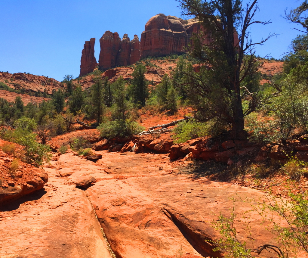 Like a meditation center, hikers can be found circulating the massive Rock, and camping out in groups of spiritual seekers. There are trails for biking as well, for those who are prepared for the rocky terrain..
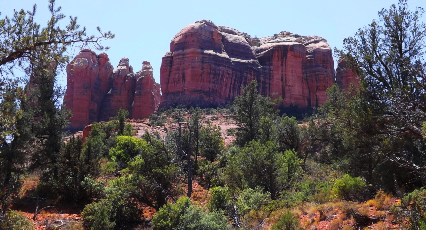 There are offshoots of the main trail here that are hard to understand. Some of the bedding of the rocks look as if water once rushed over the stone, obviously in another Era. Amazingly, there are cross section here, delicately etched into the stone, just like in the rocks of the trails back East.
 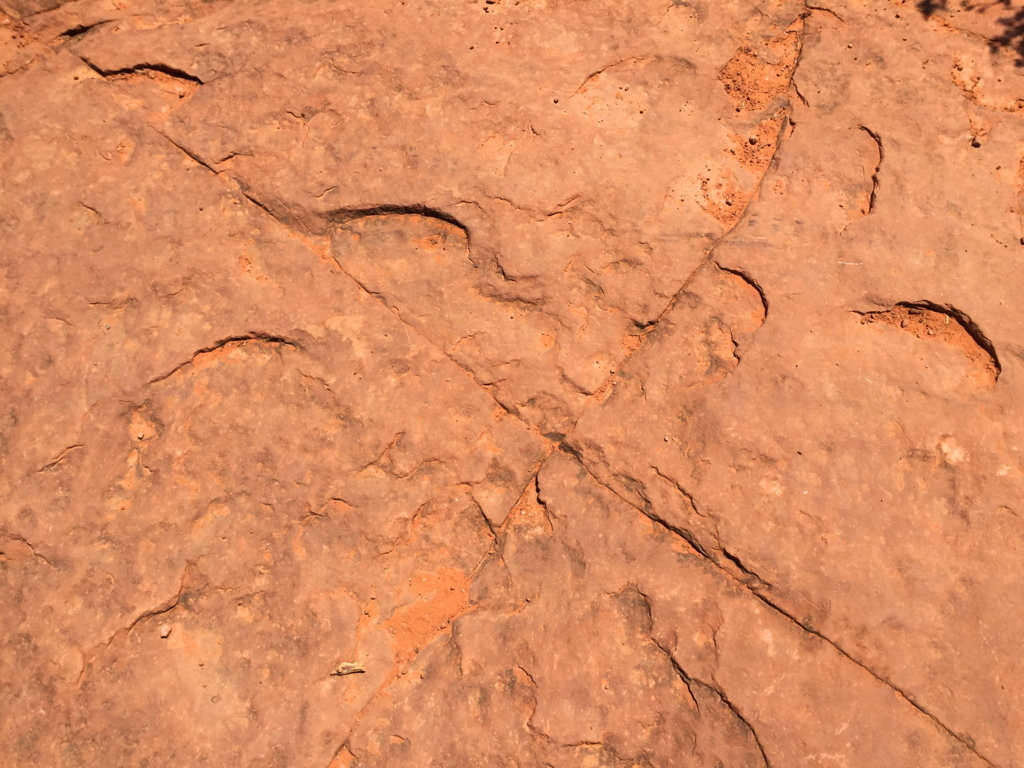 This one, pictured on the left, is at Cathedral Rock Trail; the one on the right is at Watatic Trail, 1800 miles away.
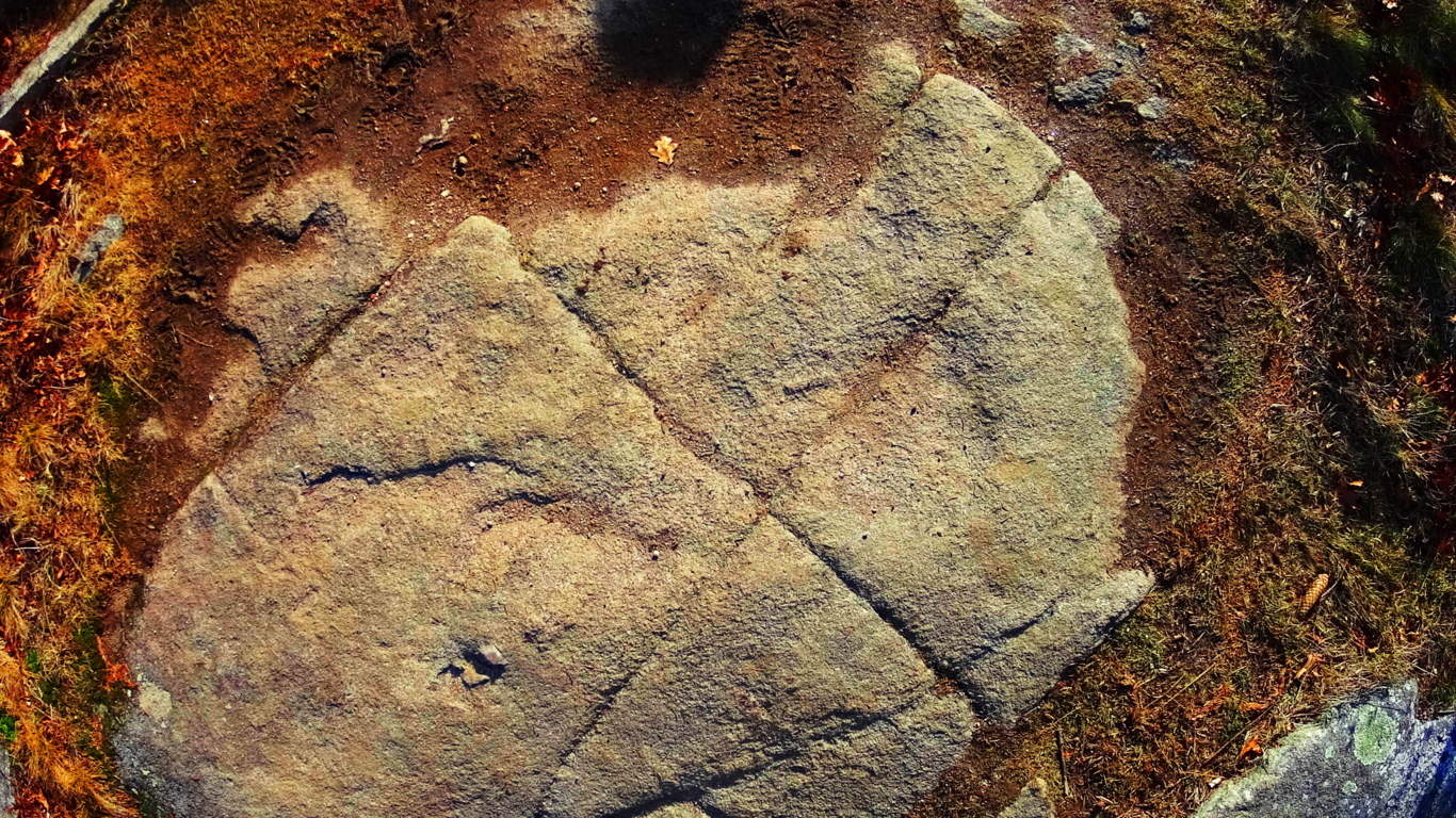 What is the meaning of these cross sections, which are found in the ancient rocky sites of the world? As described in other articles, I believe they are the “calling card” of a Neolithic Culture, which created cross section of triangles as a utility for building, as well as a tribute to the divine concept, which is The Axis of creation, a philosophical concept from the beginning of Time.
There are deep cuts in the landscape leading away from the wide bed-rock faces. They are tempting to climb into, but beware of snakes, and other wildlife. There are also stones that are clearly cut, and not average debris, but the amount of possibilities as to who may have done this work are too general to specify. 
Red Rocks National Park is a place unlike any other in the world. One could spend a life time hiking and researching its epic features and indigenous mysteries. The colors here, the scale of everything you see, is overwhelming. For those first-timers, try these basic trails first, and make time to visit Sedona. There is a vibrant Arts community here, with a social scene to match. Arizona, overall, is a hiking paradise. You can feel that something incredible took place her once, however hard it is to put your finger on. Perhaps the myths are just a hint as to what this place was before the West invaded.
Red Rocks National Park is just one of just dozens of national parks, each one being an absolute gem, like Oak Creek Canyon, Grand Canyon, Hulapai Mountain, and Sunset Crater, just to name a few. An experience here increases your overall ability as a hiker, drastically, as you are moving in 105 degree heat, roughly 4000 feet above Sea-Level. When you go home you will be significantly stronger. The energy is obviously radiant, but purifying and straight-forward, without any room for wasted effort or lazy mistakes; yet in places where the stakes are higher, the value of the experience enters into that realm of spiritual appreciation that makes hiking the very real meditation that it is. Red Rocks National Park is that experience. Give it a shot if you can, and go strong.
Bear’s Den
 Location: New Salem, Massachusetts
1
2
3
4
5
Note: Among the initial benefits of hiking… the quiet… the calm… the fluttering of the leaves above, the splashing of streams below, are more miraculous treasures waiting to be discovered. Bear’s Den is one of the most astonishing example’s of this possibility in New England, and even the world. Located just off a quiet road of a small unassuming nature preserve in New Salem Massachusetts, Bear’s Den sits ready to reveal some of the most incredible things a forest can offer on either side of the Atlantic. To begin, tucked into a small gully just beneath the initial trail is an exquisite example of an ancient stone-dwelling. 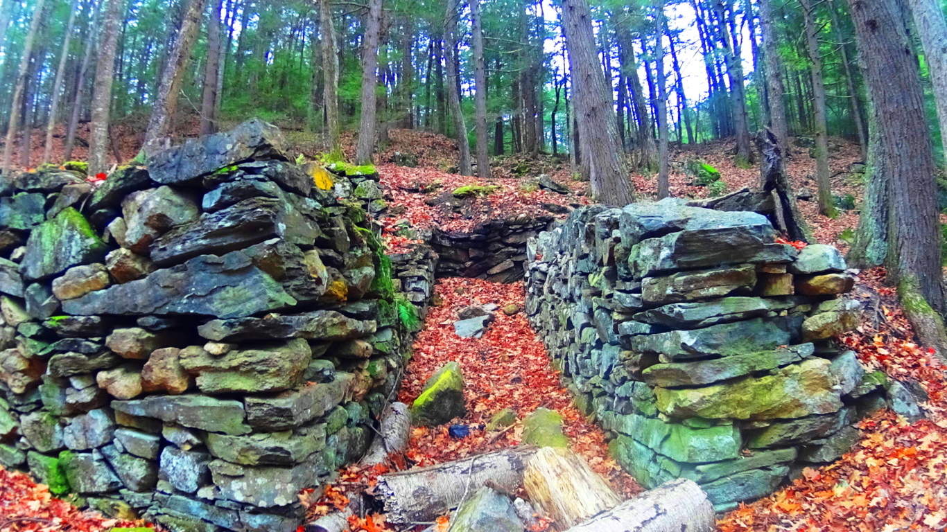 This structure has distinct dry-laid outer walls up to 7 feet high, with unique stones that are each deliberately placed and crafted in an amazing way.
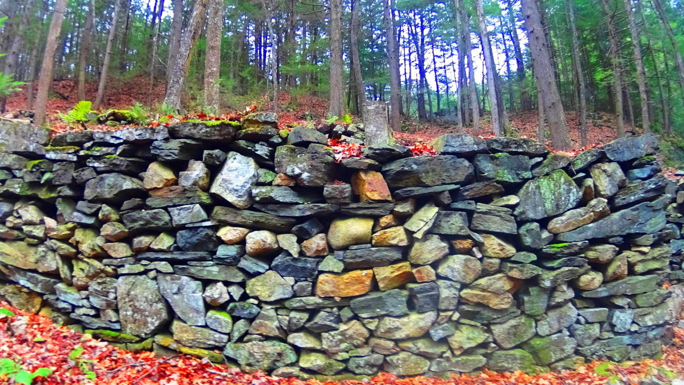 There is an entrance way leading to a single passage that opens on the interior to a leveled-off, stone-supported, bed space.
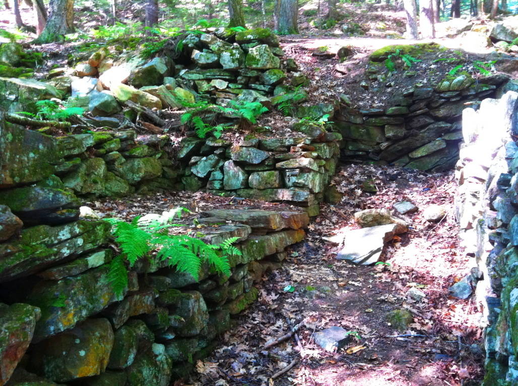 When entering the chamber you feel like you’re in someone else’s home, like a Neolithic apartment for one. There is 4 ton ‘squared’ granite piece sitting high-up on the exterior side wall, across from the bed space that looks very much like a stylistic statement made by the builder. Through sheer size, this megalithic stone says: “Look where I can put this gigantic stone!” This certainly doesn’t look like Colonial work of timely practicality, which usually involves simple cobble and brick, and avoids megalithic size stones. Native Americans were not interested in moving megalithic stones either, or building stone dwellings in north-east America. In terms of historical context, it seems that this structure somehow would’ve been here before the natives arrived, and is not the first instance of ‘megalithic culture’ at the birth of antiquity. This coincides with the claims of native Peruvians, for example. who blatantly claimed that the megalithic structures, built high in the mountains, were there well-before their ancestors arrived.
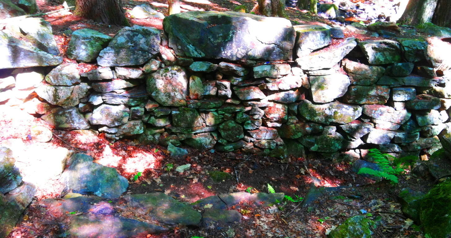 The combination of difficulty, along with the additional craftsmanship of this stone, gets our undivided attention, which is probably the point! To set in place, and perfectly level, a 4 ton granite block that sits 6 feet above the supporting smaller stones, is outstandingly bold to say the least, and incredibly difficult. It’s as if the builder wanted more of a challenge. People in New England that call structures like this a “colonial root cellar” are mentality and logically lacking. It’s the equivalent of calling Stonehenge “just a bunch of big rocks”, when we know it’s obviously so much more. And the intrigue at Bear’s Den just intensifies from here. From the stone-dwelling, follow the trail to the top of the knoll to the north.
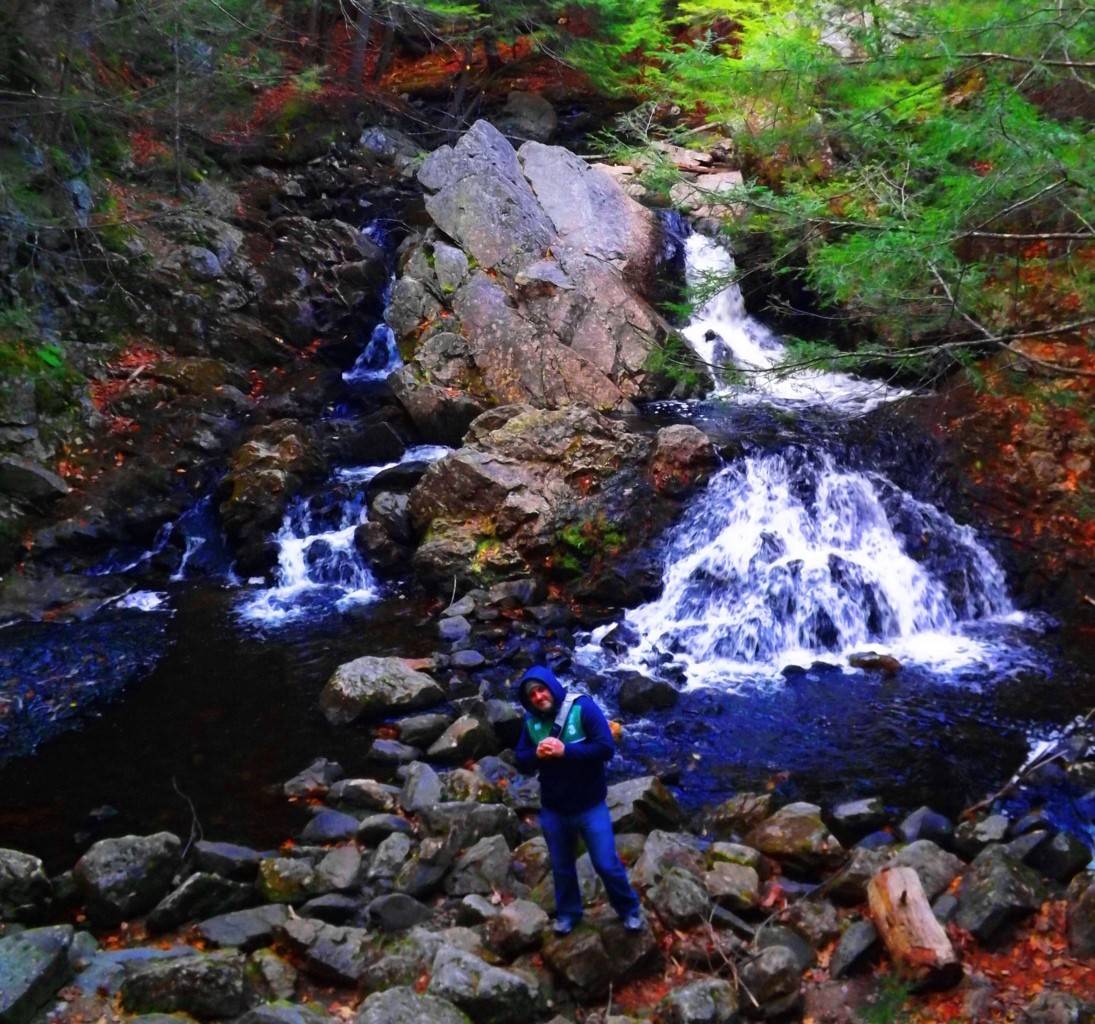
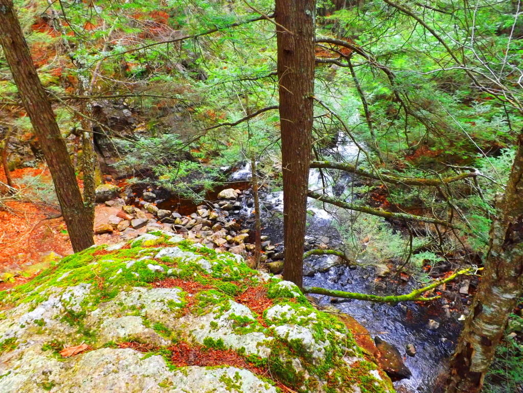 Free-sitting boulders at the top of the knoll are crafted, creating an entrance way and designated view of the waterfall on the other side. Two specifically elevated and leveled stone porches sit facing the waterfall at an intended height from about 25 yards away. What you are about to see is exquisite. The first glance of this picturesque waterfall from this elevated stone-porch reveals multiple features. The stream is split beautifully by a massive stone facade. The water that flows to the right of the main facade funnels through a specifically cut ‘spout’ down into an incredibly crafted leveled pool. This is where the scene begins to become surreal, mathematical, and incredible. Before continuing, take a look at the close-up image of the right side of the ‘funneled waterfall’ (2nd image below) and see if you notice anything unique about it. It’s impossible to miss…
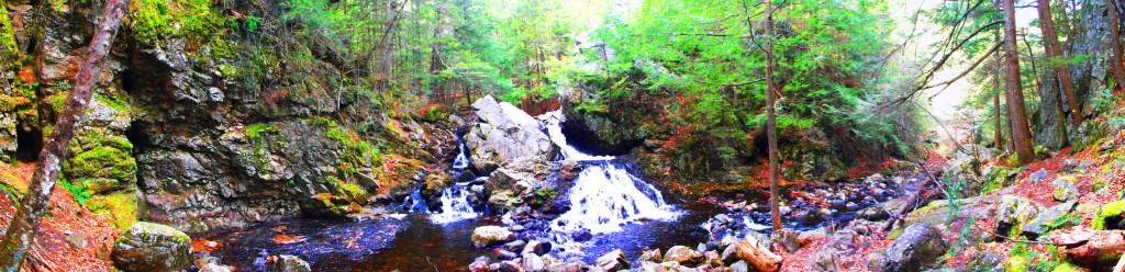
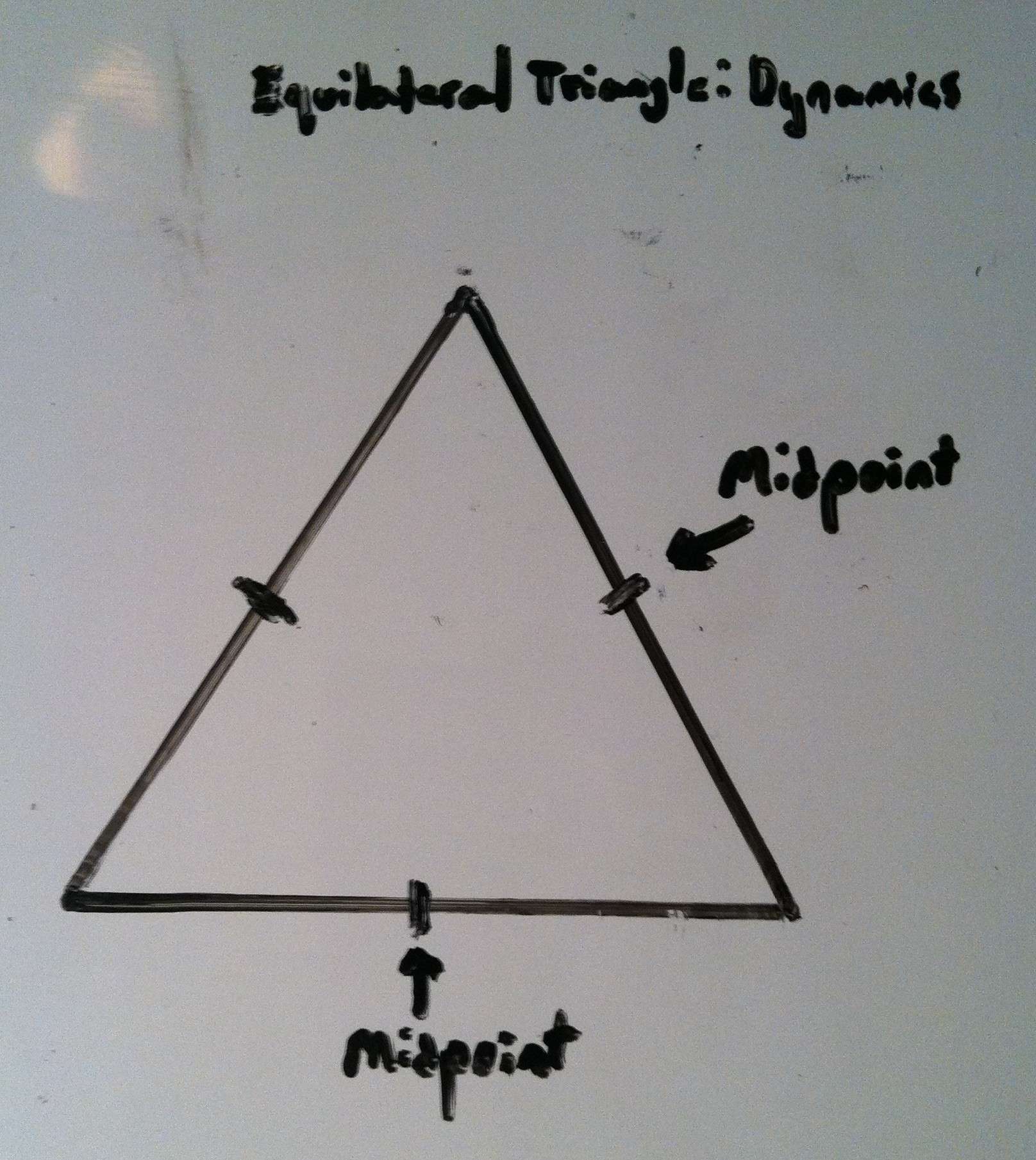
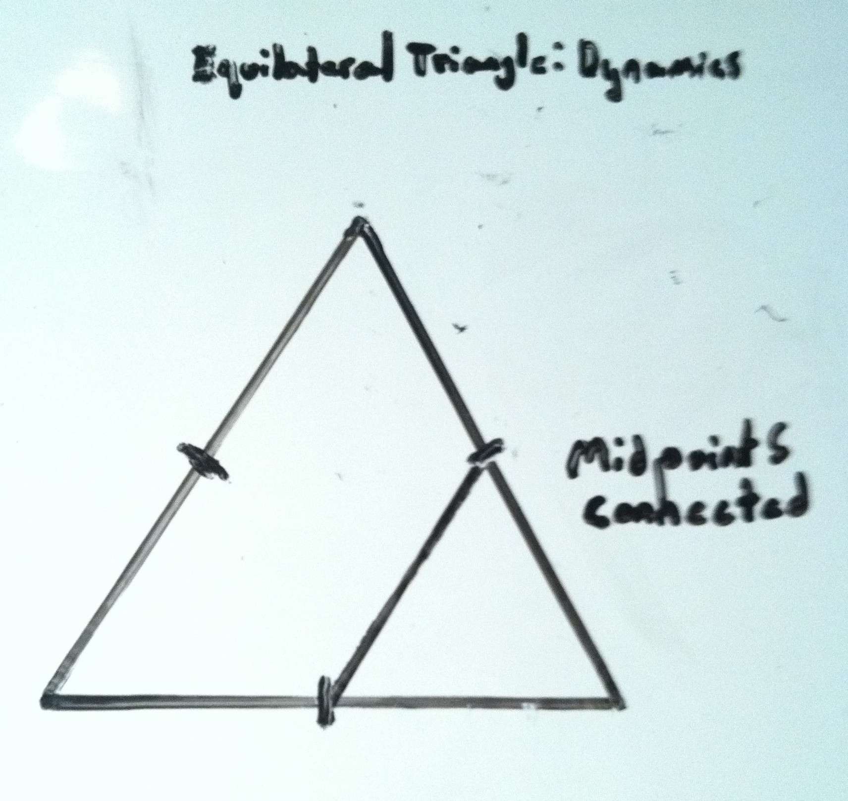
The Emblem Stone: Along the inner line of the perfectly leveled pool receiving the water from the funnel, is a beautiful granite-cut emblem of an equilateral triangle, each side being about two feet long, but looking smaller from a distance. Equilateral triangles DO NOT OCCUR IN NATURE, so we immediately must begin to wonder, who could have done this, and why? If you look closer, there is also a line inside the triangle clearly connecting the midpoints of two sides. A line that connects the midpoints of two sides creates an angle of 60 degrees.
 It appears that this emblem is depicting a specific geometric relationship. (Shown on the right) All of a sudden, the waterfall too, is an anthropological site.
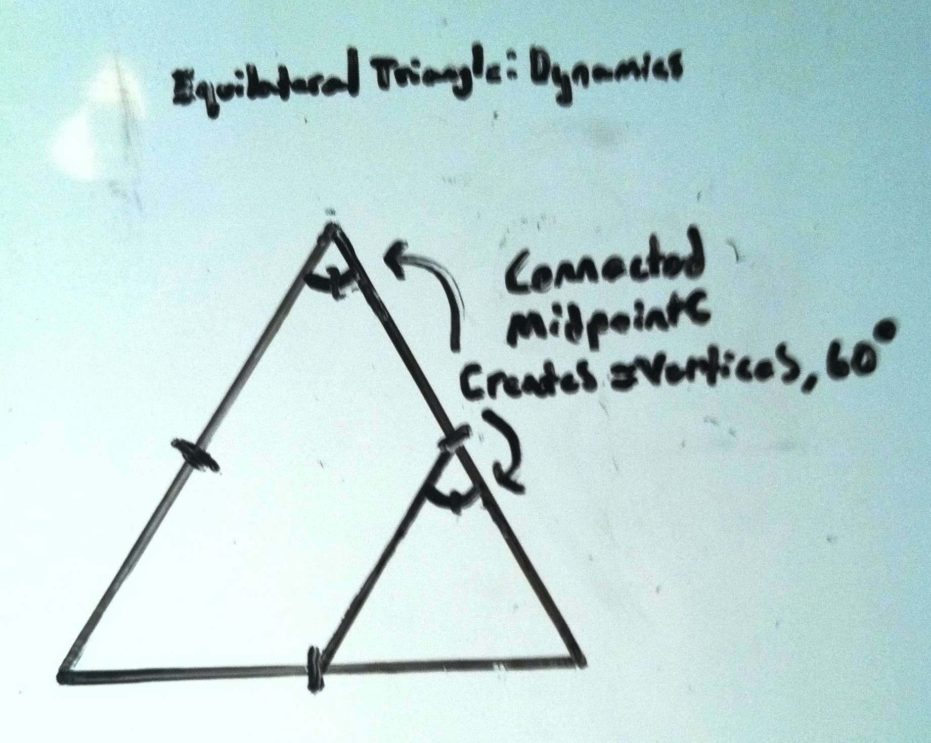
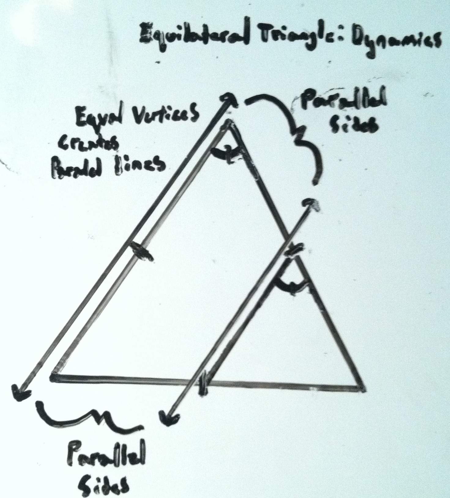
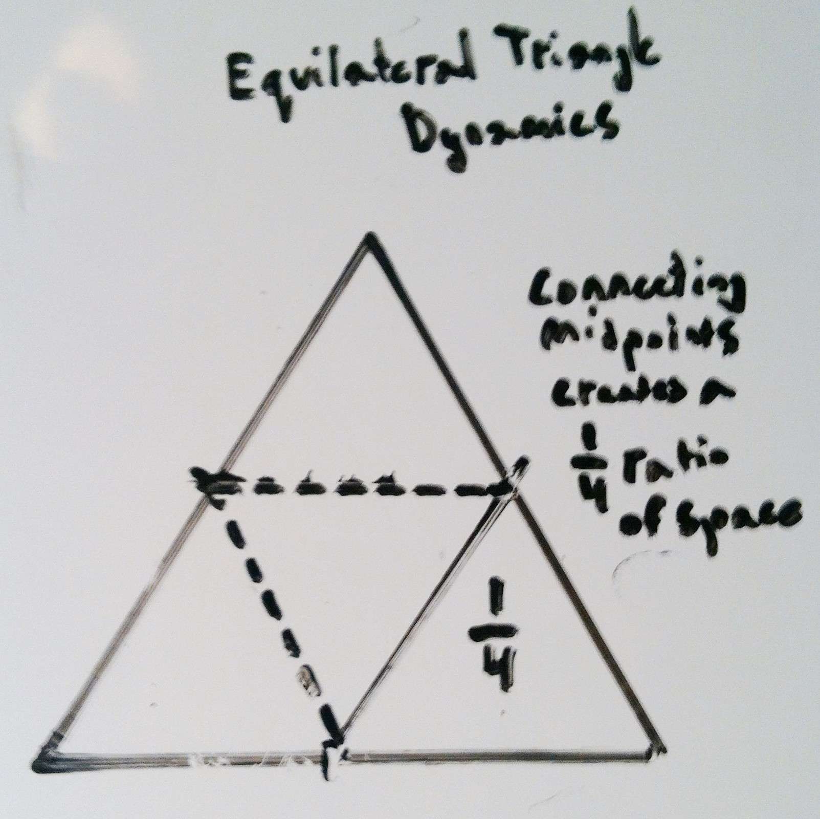
Simple Geometry: (Please look to the diagrams 1-5 above to see the proofing of these ratio’s and parallels): At this time a few simple geometric explanations are required which only take a moment. Due to the midpoints being connected within the triangle, the vertices of the smaller triangle become equal to the vertices of the larger outer triangle, at exactly 60 degrees. Further still, since the vertices of both triangles become equal, the sides of both the larger and smaller triangle therefor become parallel. When these relationships are proven, the smaller triangle is revealed to be exactly 1/4 ratio of the entire figure. This is absolutely astonishing. Logically we must accept a few things at this time. First, it should be understood that whoever etched this emblem did so in granite, and for a reason. We have to conclude that the designer absolutely intended for us to notice it. In fact, the only guarantee that it would be noticed, is to etch it in granite. Second, the specific geometry of the emblem is a message, a coded stone, informing us that the designer was obviously well aware of Sacred Geometry. Third, if someone from antiquity is leaving us a coded emblem with specific geometric relationships, it demands our utmost attention, and we should be adamant to observe any other relationships taking place, relevant to this emblem.
The Funneled Waterfall Parallel: It is logical to follow the lines of the parallels that have been established by this emblem to see if there is any further connections on the waterfall overall. If we continue the line of the left side of this coded emblem, we see that it connects DIRECTLY to another crafted feature. Continuing along this exact line is a crafted stone funnel where the water is harnessed specifically to a single focal point. This exact line is becoming a longer parallel.  You can see the distinct whiteness of the water blasting out of the funnel. At this point something astonishing is beginning to emerge. The possibility that the ’emblem stone’ is a coded statement for relationships relevant to the entire waterfall is becoming possible. If this parallel line extends to a specific point on the larger structure, is it possible that this line will have a matching larger parallel on the other side of the waterfall, just like the lines of the emblem? Is it possible that another larger triangle can be established relative to this right-side portion of the scene? Let’s continue to try and find features that fit the ratios and angles. If we continue to implement the information the emblem conveys, from this top funnel point we can implement a 60 degree angle, and draw a line downward at this specific angle. We will then continue to draw that line down to a point where we can implement another 60 degree line at the base. If we do this, another perfect triangle emerges, depicting an outline of the ‘funneled-side-waterfall’ on the right-lower side, exactly as depicted in the right-lower side of the emblem stone.
 From here, if we want to see if there is a ratio-appropriate parallel to the ‘funnel-waterfall-triangle’ on the 3/4 side of the scene, we need to step back to where we can see the entire picture again.
The Top Central Boulder: Returning to the leveled stone porch, we must look for a central point where a larger parallel line can converge, in accordance with the pattern on the emblem. Remember that the emblem depicts a specific 1/4th ratio for the smaller triangle within, therefor, a higher point in the 3/4ths section on the right should specifically exist. Let’s continue to look for this intentional designation. If we examine the upper-left portion of the overall waterfall, we DO see something specific. Looking down from the center of the elevated porch, directly below is a set of distinct stones that serves as a central bridge that connects the land across the stream with the granite facade. If we follow this line we can see that it directs our eyes straight ahead to the exact high-point on the massive frontal/main granite piece, where there is a distinct crease cut into the rock (double click o image to the right to look closer). Directly above and behind that crease is a free-standing boulder, placed centrally (circled at the top. in yellow).
 It is certainly important to check these points of significance to ensure that they are not arbitrary. It appears that the aligned stoned bridge is directing us towards this specific boulder. If you cross this bridge, which is completely linear, and climb up to the cut crease, then make your way to the centrally placed boulder behind the facade, and turn around, there is something spectacular we are intended to see.
The Aligned Rear Altar: Here we see what looks to be a type of “water-altar” embedded behind the uppermost granite facade where the crease is. The cut line of this uppermost crease is even more distinct from the back side, revealing an exact cut that extends as an incision deep into the granite at a 45 degree angle. Looking back now from the center of the boulder, through the crease, back to the elevated porch, is a perfectly straight line, as well as a perfectly leveled line (Image marked below, left). The alignment, symmetry, AND elevation, are all absolutely exact. This rear section is obviously another type of ‘alter’ intended to be found by use of the information given to us by the emblem. Along the line of the ‘high point crease’ is a circularly cut whirlpool, with a back drop of smaller stones with little incisions that follow the 45 degree lining of the top most crease. These are blatantly angled cuts in solid granite. This is also the exact spot where the water divides into two sections, cascading down to the left and to the right onto the frontal facade (Image to the right). As the high point of division for the stream, it is further justification as an identified high point to the main frontal facade. All of this information serves to reveal the free standing boulder behind the uppermost crease as a central high point, intended for us to discover by the efforts of the designer of this waterfall. With this important piece of information, we can go back to the elevated porch on the frontal side of the waterfall, and utilize the ‘top boulder’ as our fixed point for the parallel line we are hoping to find, which will logically coincide as a parallel with the ‘funnel-waterfall-triangle’ line on the more minor lower left side of the overall facade, just at the top corner and the mid-line corner coincide on the emblem.
The overall waterfall and the emblem are the same: If we extend the ‘funnel-waterfall-triangle’ lines, at the angle of 60 degrees indicated to us by the information within the ’emblem stone’, this line will run straight to the peak of the ‘top boulder’. It all comes together from here. The outer line connecting the ‘funnel-waterfall-triangle’ to the specific point of the ‘top central boulder’ is enough information to allow us to complete the picture. 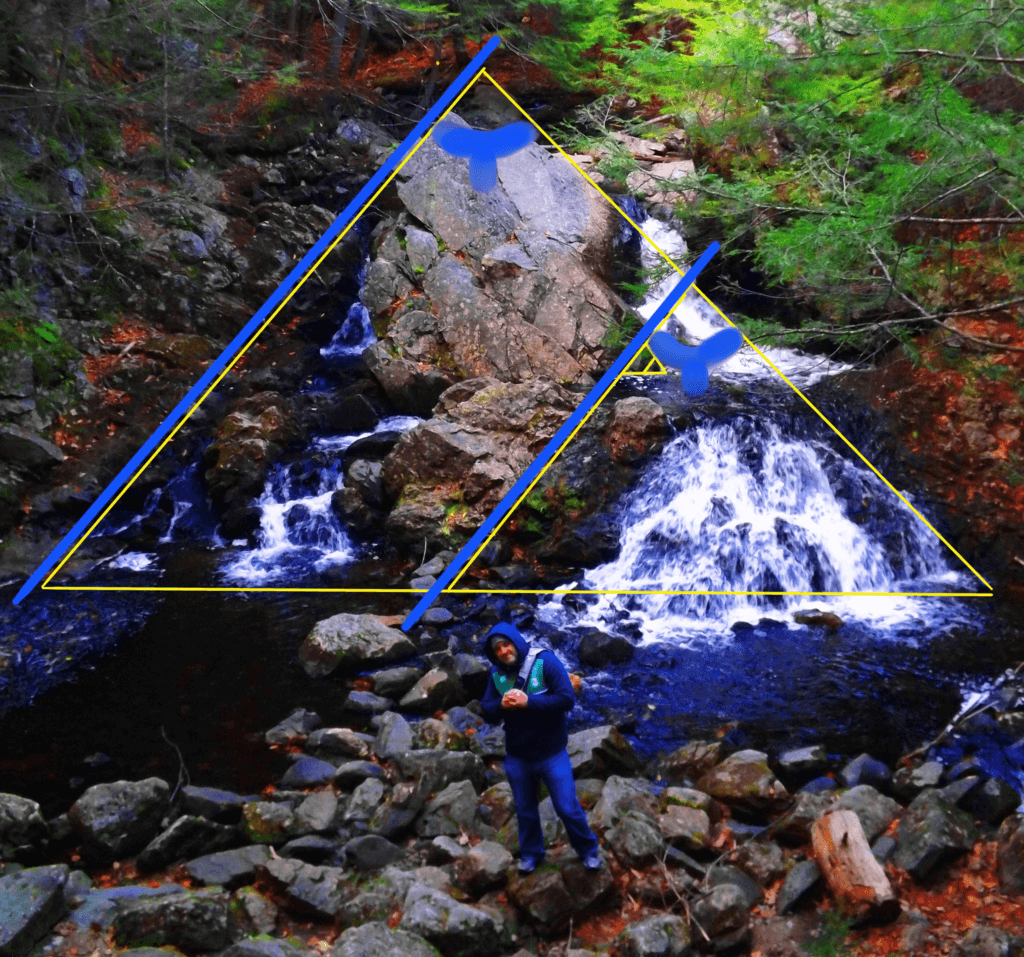 If we again use the 60 degree angle implied by the emblem stone, we can now draw the parallel line we were searching for, that coincides with the ’emblem-to-funnel’ line. We draw the line as a parallel from the ‘top boulder’ down, and the picture begins to emerge in full. The parallel lines are in specific ratio as well, so it becomes impossible to miss. If we match the 60 degree corner of the established ‘outer right-side line’ on the right-side extremity of the waterfall, we can define a 60 degree corner on the left-side extremity and run a base line from one end of the fall to the other. Here we see that THE RATIOS OF THE ORIGINAL CODED EMBLEM EMERGE AGAIN IN THE OVERALL WATERFALL (displayed below). We now see, by definition, that the 1/4 ratio portion of the overall triangle is the ‘funneled waterfall triangle’ with the ‘leveled pool’ on the minor right corner. It’s a perfect fit. What we have discovered is that the ’emblem stone’ is nothing less than an embedded, ratio-specific ‘keystone’ that opens up the possibility of comprehending the entire picture.
Mystical Beauty: There are so many question that come from discoveries like this. Who would have the ability and knowledge in antiquity to create an engineered, ratio-specific, waterfall from cut granite? This just doesn’t coincide with the evolutionary depiction of history, where humans are depicted as primordially primitive. Perhaps the builder was not entirely human? It’s not just the magnitude of understanding, its the ability to carry it out that’s really moving. The emblem shows us the mind of the engineer of this waterfall; That beautiful ideas can have a core principle, and be carried out into complexity by the consistency of defined ratios and principles. To do this in antiquity is earth shattering. It seems likely that the engineer of this masterpiece lived in, and also designed, the elegantly simple and beautiful stone-dwelling just over the hill. It makes sense. The stream flows from the waterfall, around the hill, straight to the dwelling, and beyond.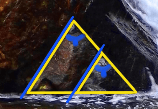
It is a captivating scene.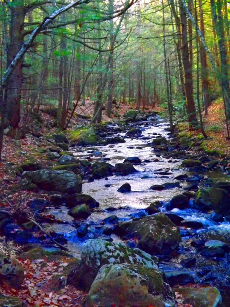 For a moment, picture a pristine Era at the beginning of Time, when the water was clean and drinkable. This area was carved-out as a place of pure joy and regeneration, perhaps in the very first Era. It is at least one of the oldest functioning engineered sanctuaries in the world. It’s haunting; where trails run along the river above the waterfall and below, through the forest and back to the stone-dwellingl for a 2.5 mile loop.
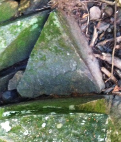
The Equilateral Triangle: The equilateral triangle is a feature that actually shows up in many New England forests in several different ways. In my personal explorations for content for Stonestrider.com, I’ve seen large granite cuts, subtle small granite pieces on mount Watatic, Massachusetts, with holes somehow drilled smoothly into the exact center. and massive granite slabs in deep woods with 60 degree quartz stripes across the face (bottom images). On my way out of Bear’s Den on my most recent visit this September, just down stream from the waterfall, I discovered another cut equilateral triangle, this time laying right beside the boulder it was cut from (green stones on the lower left).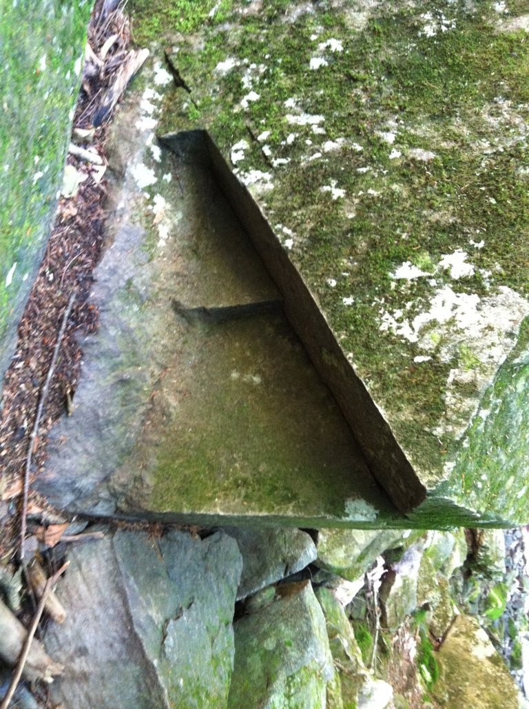
 This is Neolithic meme in New England of incredible and profound significance. The culture that appreciated this specific geometric shape engineered it into their lives, in their work, and in their hearts. The ancient Israelite immortalized the equilateral triangle in their designs of the Ark of The Covenant and later in the Temple, as instructed by Ashem (Yahweh,God). A functional living monument dedicated to this shape conveys a message across the Ages, which is that the builders were connected intimately with this divine principle. If you explore the forest and mountains of New England, as well as the Celtic high country, it is only a matter time before you discover this for yourself. Hope to see you out there.
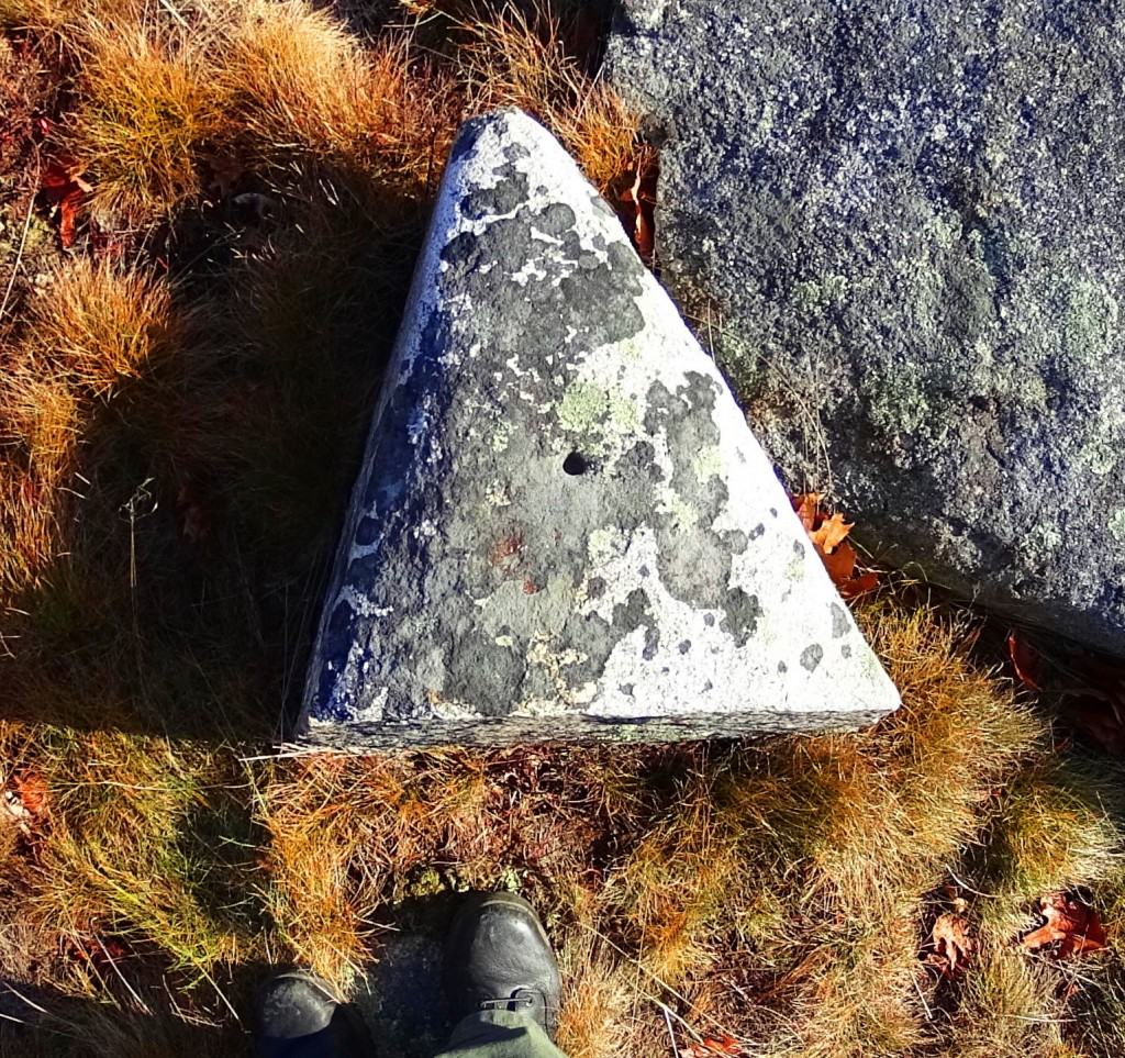

Cavan Burren National Park (Part 1: Celtic Altar)
 Location: Blacklion/County Cavan Ireland/Cavan Burren National Park
Note: If the quintessential Celtic ‘dreamscape’ is what you are hoping to find in a hiking experience, Cavan Burren National Park is the place for you. This pristine pre-history landscape is sacred on every possible level, with roughly ten square miles of Celtic wildlife preserve. Embedded in the surreal panoramic vistas surrounding Cuilcagh Mountain, on which the park is mainly canvased, are priceless 5000 year old Wedge Tombs, Alters, Dolmens, and megaliths. A fantastic trail runs from the main entrance/visitors-center of the park to beautiful anthropological sites. The area is absolutely worthy of several specified reviews for each of the sites along this main route, but the real wonder of the region, and perhaps it’s most establishing distinction as a truly Celtic reserve for both exquisitely rare natural fauna and neolithic cultural gems, is that the off trail hiking reveals supremely beautiful works of ancient stone engineering as well. I discovered this incredible alter, featured in the title image above, by interpreting the lay of the engineered stones expressed over the landscape. Postmodern anthropologists have taken a dismissively poor perspective on what they have lazily identified as “farmers walls” looping over the hillsides. These “farmers walls” are not “walls” at all; functionally they do not limit the movements of grazing flocks in any way. Herds can simply walk over these stones if they so choose, so by literal definition, it is not a wall. The function of these special stones that look to our modern eyes as “walling” is actually a type of primitive ‘cable system’ that connects each sacred alter, from one to the next.
 These stone linings are like the wire that runs between a battery’s charge points, to the base-tip of a light bulb, passing energy from one end-point of energy to the next. I found this alter by following the lined stones running north west off the main trail.
 My educated guess was therefore to follow the lined stones I observed to see what special feature it was connected to. I arrived at this incredible Celtic alter wonderfully positioned at the next hilltop, approximately 1.5 miles northwest of the main trails (Top Image).
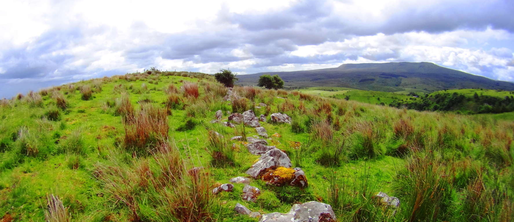 Here again was another moment where my firm belief in the premise of engineered landscapes was vindicated. The earliest Celtic cultures attempted to harness and designate the transfer of energy in the landscape with stones that absorb the energy from the sun and connect the alters sitting strategically at the top the hills. These lined stones funneled energy from peak to peak, alter to alter. Most modern anthropologists fall victim to assuming that a ‘defined sacred space’ requires a specific ‘central temple’ that celebrates the area in a basically singular declaration. What they refuse to consider is that an even higher expression of the sacredness of the landscape is of course to utilize it while celebrating it, making the entire area a type of living, functional temple which connects each elevated corner. This engineering is also present in the mountains and forests of New England. I encourage hikers to prepare appropriate gear for deeply experiencing the landscape, for trekking into wilder corners of the reserves. If you follow the stone-linings of ancient Celtic zones to areas away from the designated trail, you will soon find that the premise of engineered landscapes is absolutely real. Aside form this, the natural beauty of the area is stellar. To deeply experience any ancient landscape equip yourself with cinema-capable cameras and capture your trek.
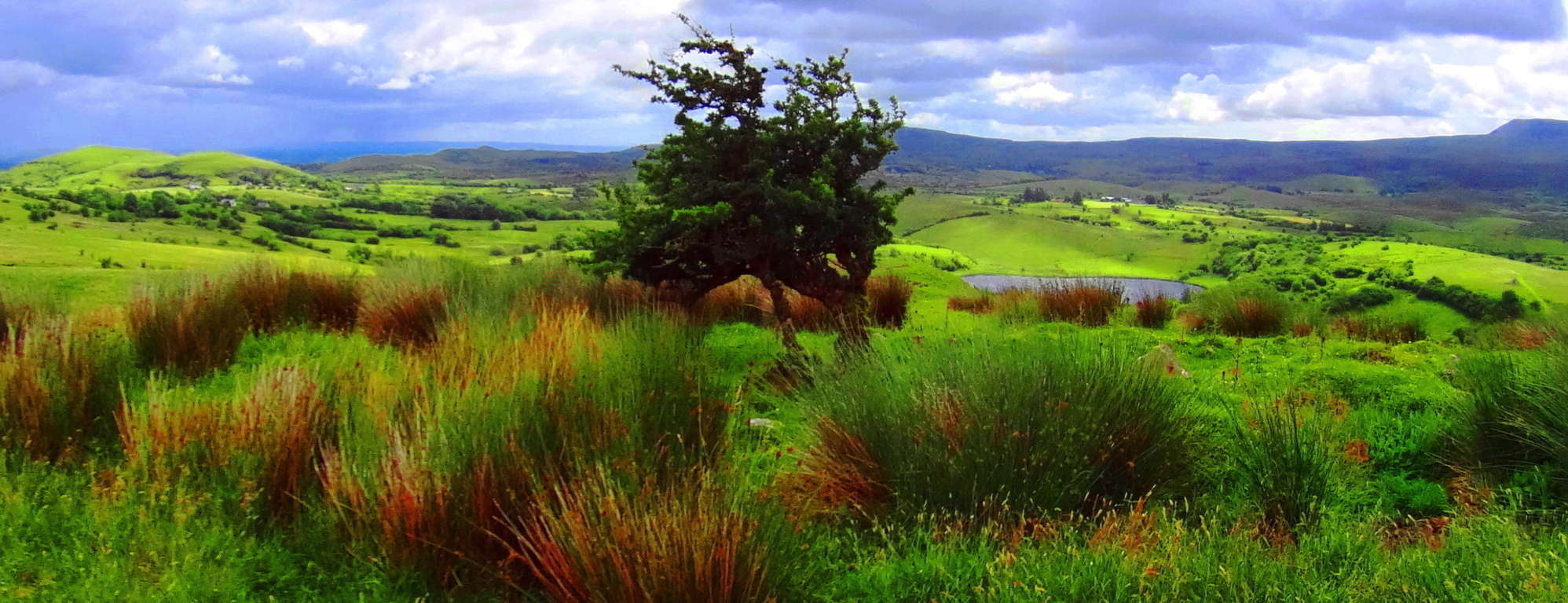 Cavan Burren National Park is a portal into the primordial era of the earths most fantastic expressions, with priceless anthropological expressions of engineering from the first culture on earth. Seek, and find it out for yourself.
Mount Monadnock, New Hampshire, USA
 Location: Mt. Monadnock/Jaffrey New Hampshire/USA
Elevation: 3,165 ft.
Massive stone work running straight UP the mountain side, defying logic. No farms or crops were ever planted here, it would be impossible. What are these stoneworks?
Note:Mt.Monadnock has an autonomous majesty that is impossible to ignore. Very much like Mt.Errigal in Ireland, Monadnock stands alone, part of no particular chain. It’s singular cinematic contrast over the New Hampshire landscape is stellar, although it is a relatively small mountain by global standards. The ‘White Dot Trail’ from the Monadnock State Reserve Station on Dublin Road winds directly to the rocky peak. Anthropological stone work inundates the mountain side, featuring massive signature stone-walling and engineering that runs straight up the mountain, of which no farmer has laid claim. Here there are indicative New England pre-native era stone-works, where 100 to 400 pound stones are crafted, and then laid one atop the other at impossible elevations, where no cart or mule, or sane individual, would build a “wall”. The pattern fits with absolute consistency to every elevated trail site in New England; massive megalithic stone works that no colonial farmer claims, taking place at dizzying elevations. Native Americans would have witnessed these stone structures with equal amazement and wonder, and they take no credit for their building either. The trail requires some hands on work to get above the tree-line, where wildflowers and stone porches emerge to overlook all New England.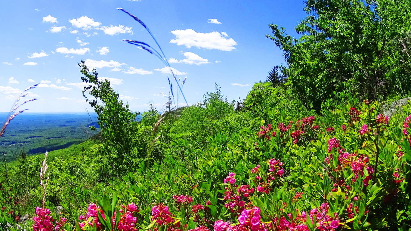 At the peak there is an incredible stone, cut and pulled away from the mountain like a giant puzzle piece, pointing straight to the Sun at Noon. This megalithic scale is similar to works found at Monument Mountain in Great Barrington Massachusetts. It seems that this first culture on Earth took control of these majestic elevations all over the world. Connections can be found between Celtic. Mayan, Native American, and Israeli megalithic sites and trails if we choose to observe them. The next question becomes, what culture is capable of creating these megalithic wonders at the beginning of Time? Monadnock is a beautiful glimpse into this mystery.
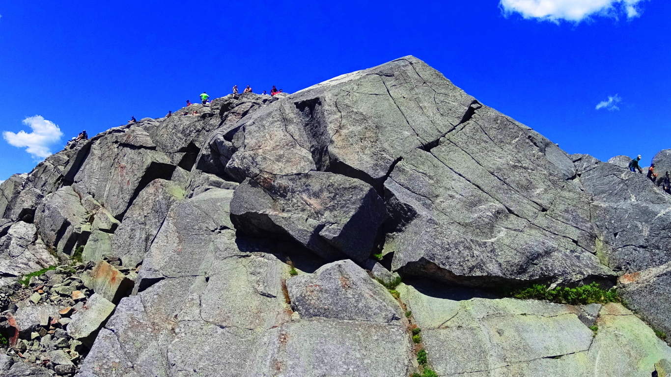
Cut block at the peak of Monadnock, pointing like an arrow to the Sun at Mid-day. The scale is surreal. Look at the smallness of the people above! Megaliths!
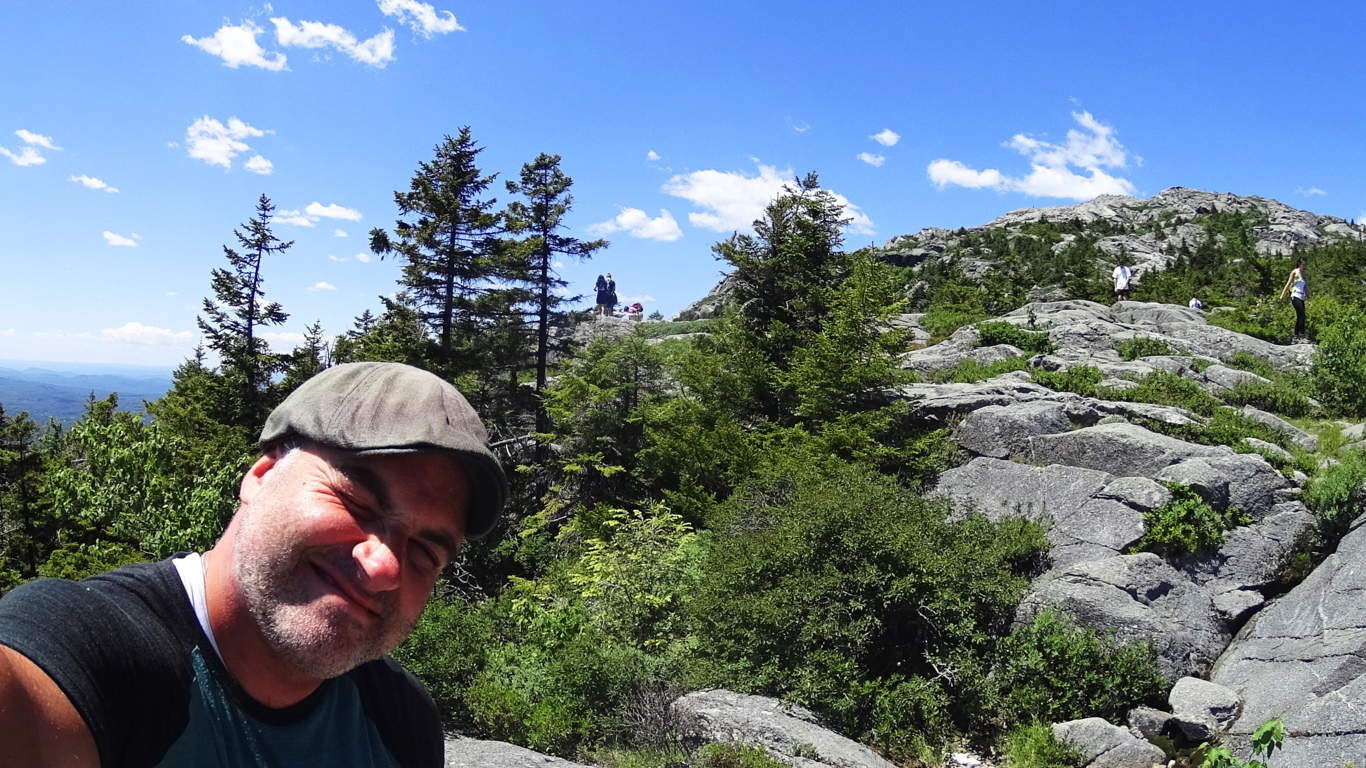
The high porch above the tree-line to the peak.