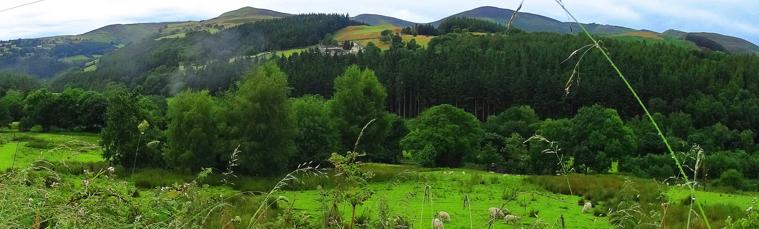
Watatic Mountain
 Location: Ashburnham Massachusetts, U.S.A
Elevation: !,831 feet.
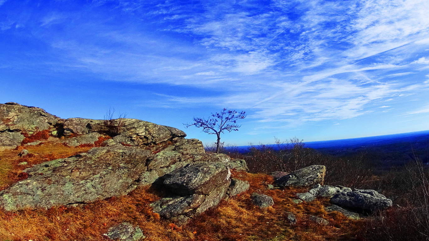
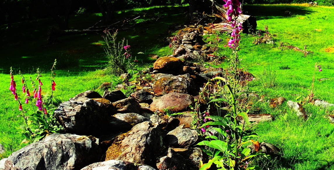
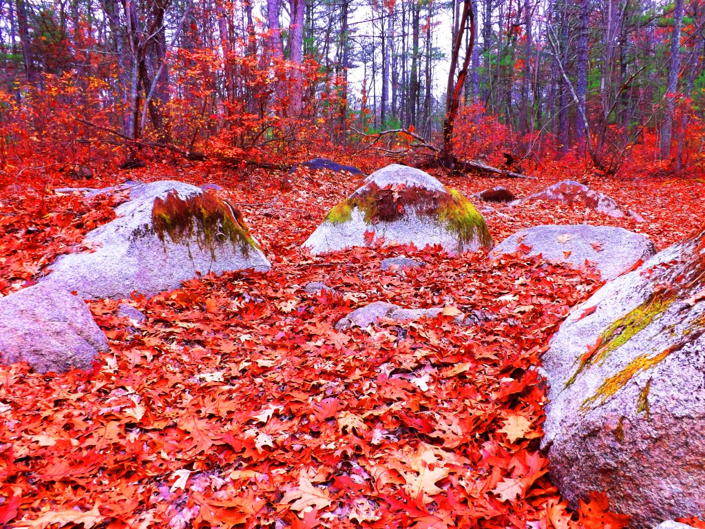
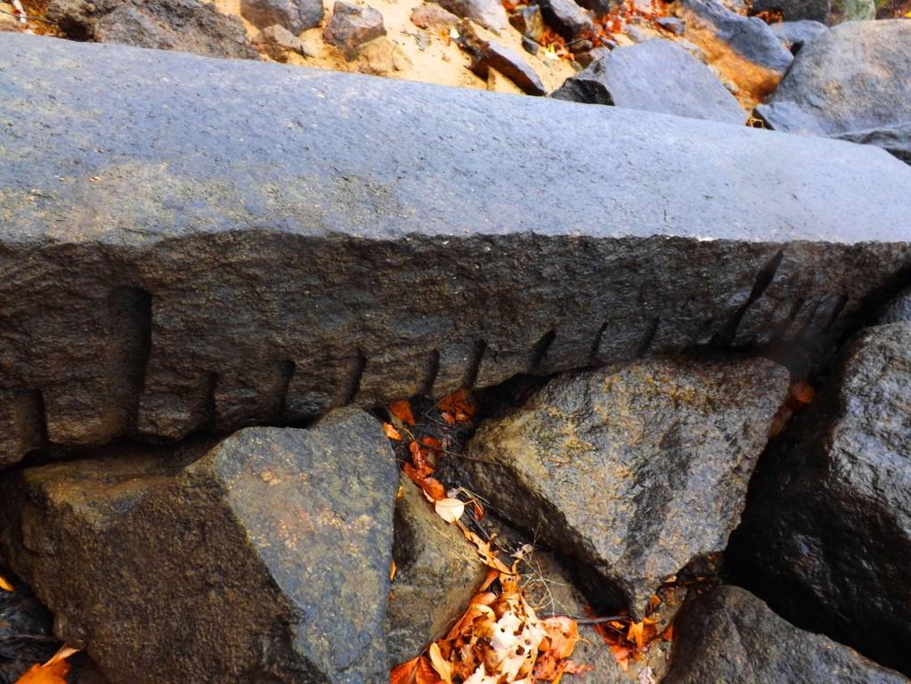
Note: Massachusetts is a haven for the ‘small mountain’ experience, with most trails peaking under 2,000 feet. For hikers with the right vision, the experience on the trails is by no means small, however. A mysterious megalithic culture existed once on the rocky peaks, pine forests, and hilly river-valleys of this area. Strongest similarities show up across the Atlantic in the ancient Celtic elevations. The climb to the top of Watatic Mountain will grant you a great view of the State of Vermont to the north. In Autumn it is a visual miasma of colors, increasing the value of the trail exponentially. The main trail is called Nutting Hill, which is just over three miles long, half of which is just about straight up, so be prepared. The megaliths are here too, making this an anthropological experience. To begin, at ground level a set of small ponds accept the run-off from the mountain. The rocky mountainside deflects the wind coming from the north, stilling the ponds surface like glass as you pass by. The level portion of the trail, just past the water, is only about 150 yards. Immediately strange stone fixtures protrude through the leaves all around. Among these fixtures are more significant signs of “signatures”, or specifically stylized workings in the stone. The ‘X’, or “diamond cross-section” is one of the most popular types.
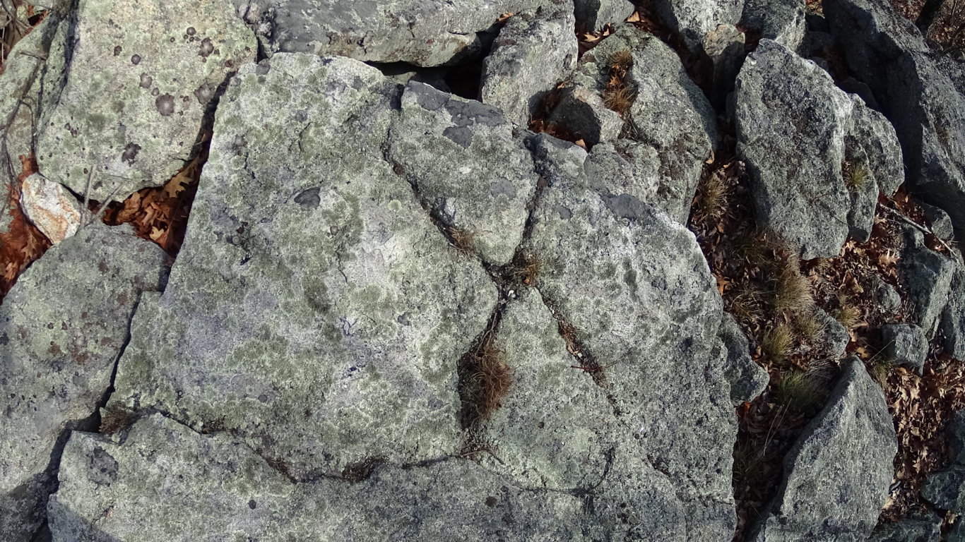
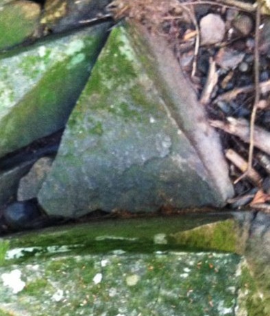
To look at these “X” sections it is nearly impossible to believe that they were created by ‘glacial displacement’. They create symmetries not only on the stones that they are carved into, but also in the stones within the vicinity of that particular signature. They are found on almost every Massachusetts trail where there is significant rock formations, both in the heights, and valleys.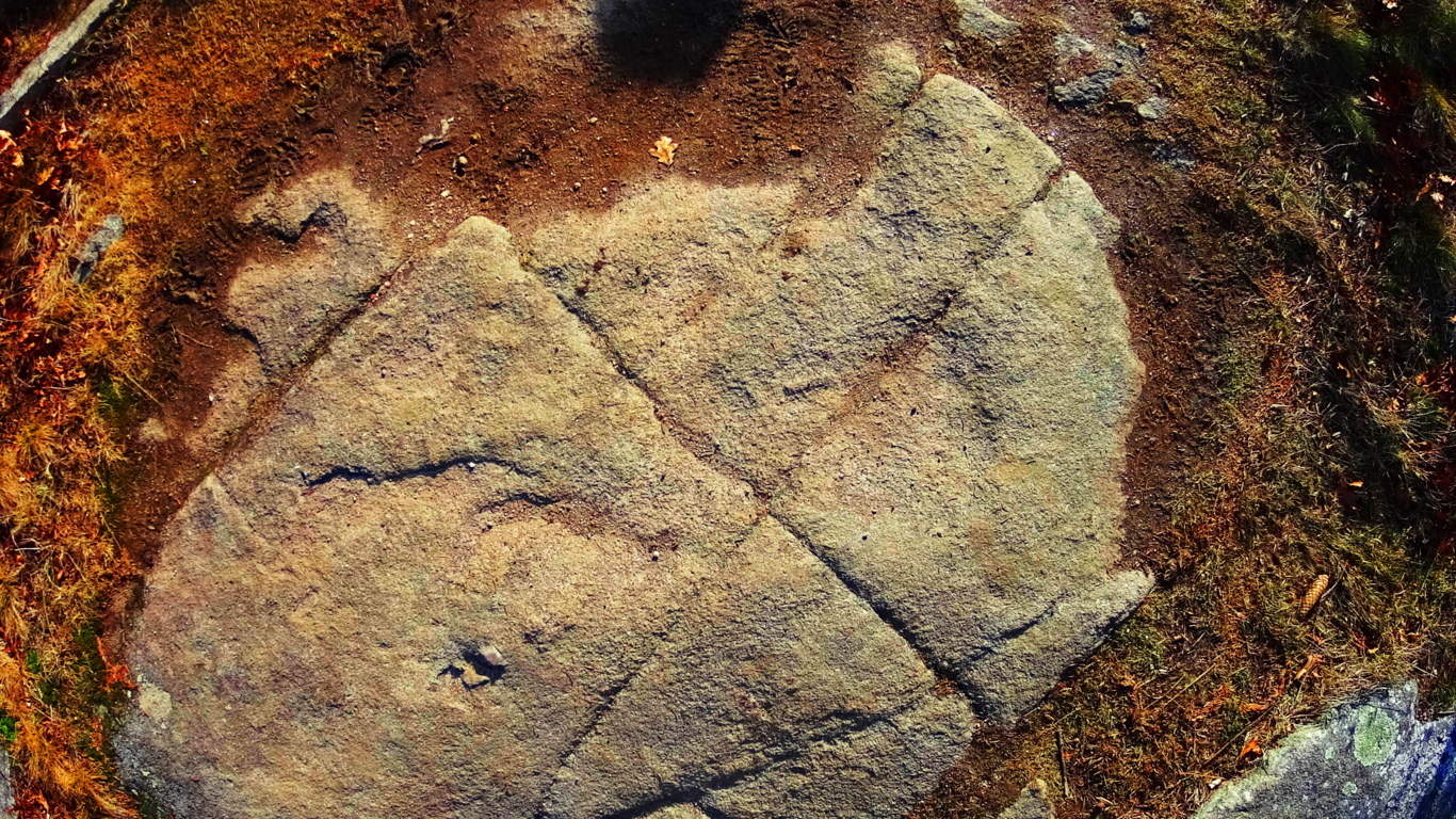 They are also found in the Celtic heights of Ireland.
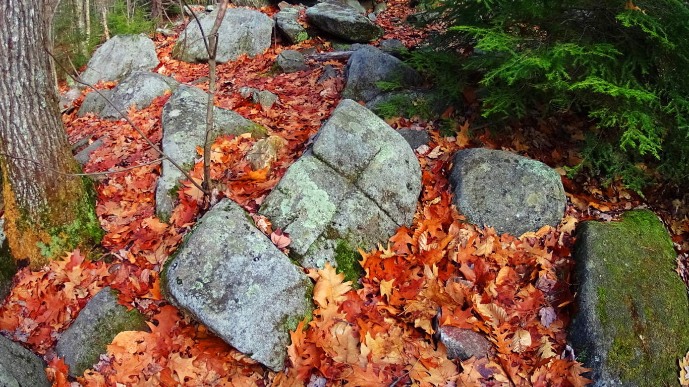
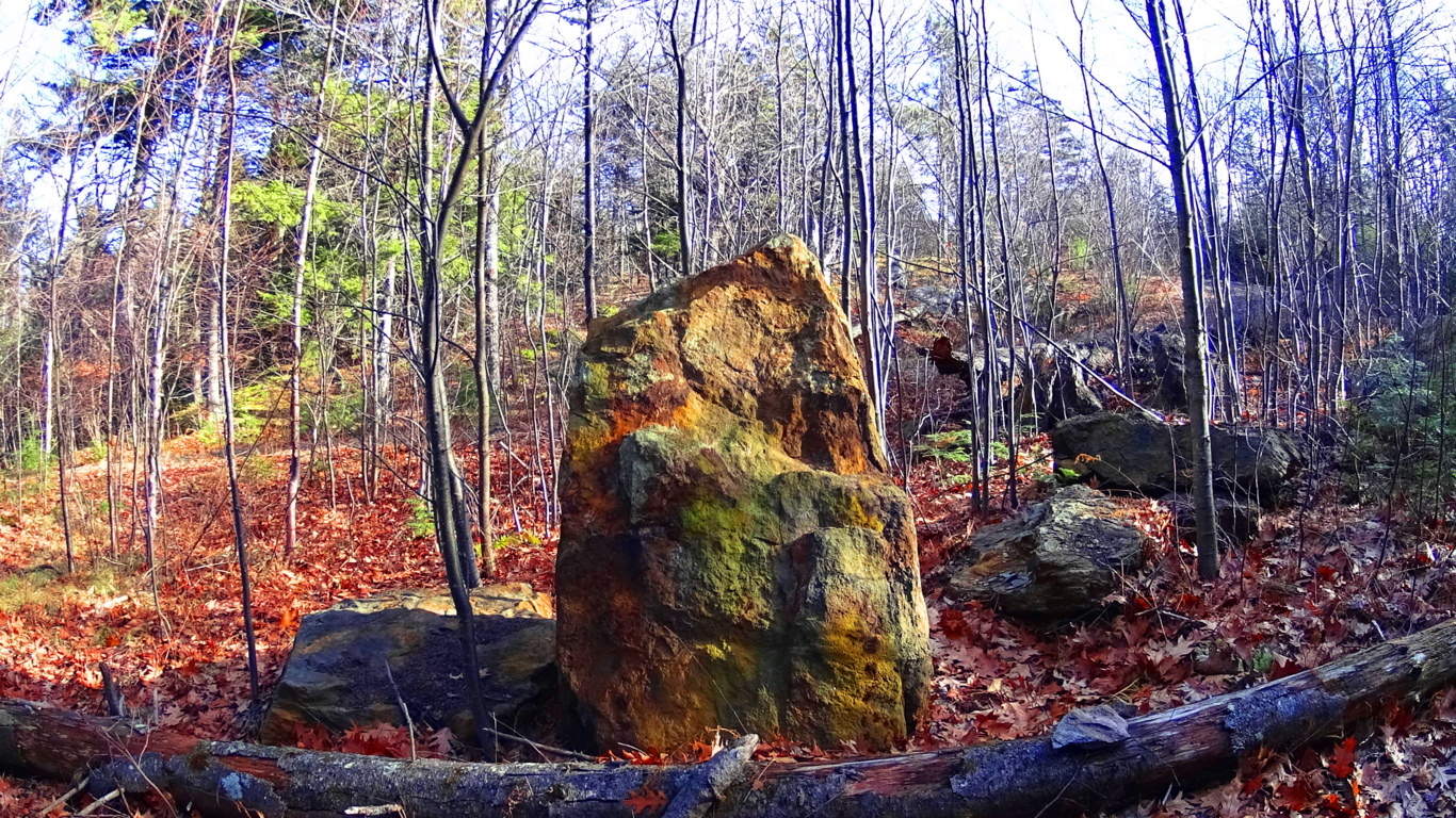
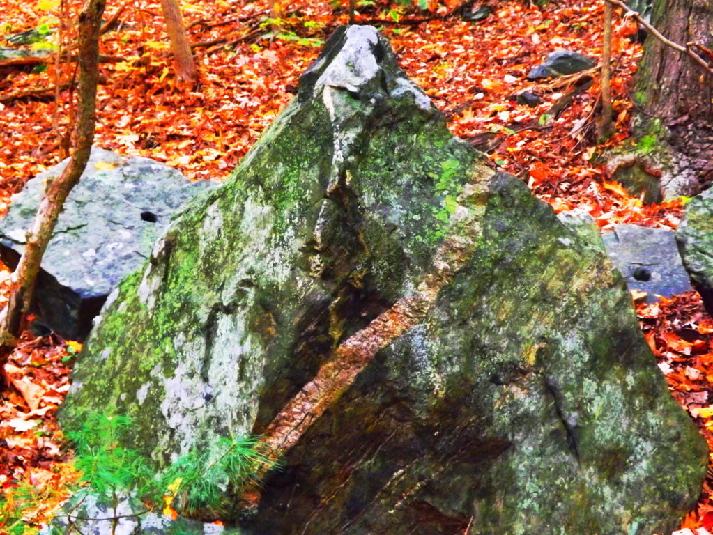
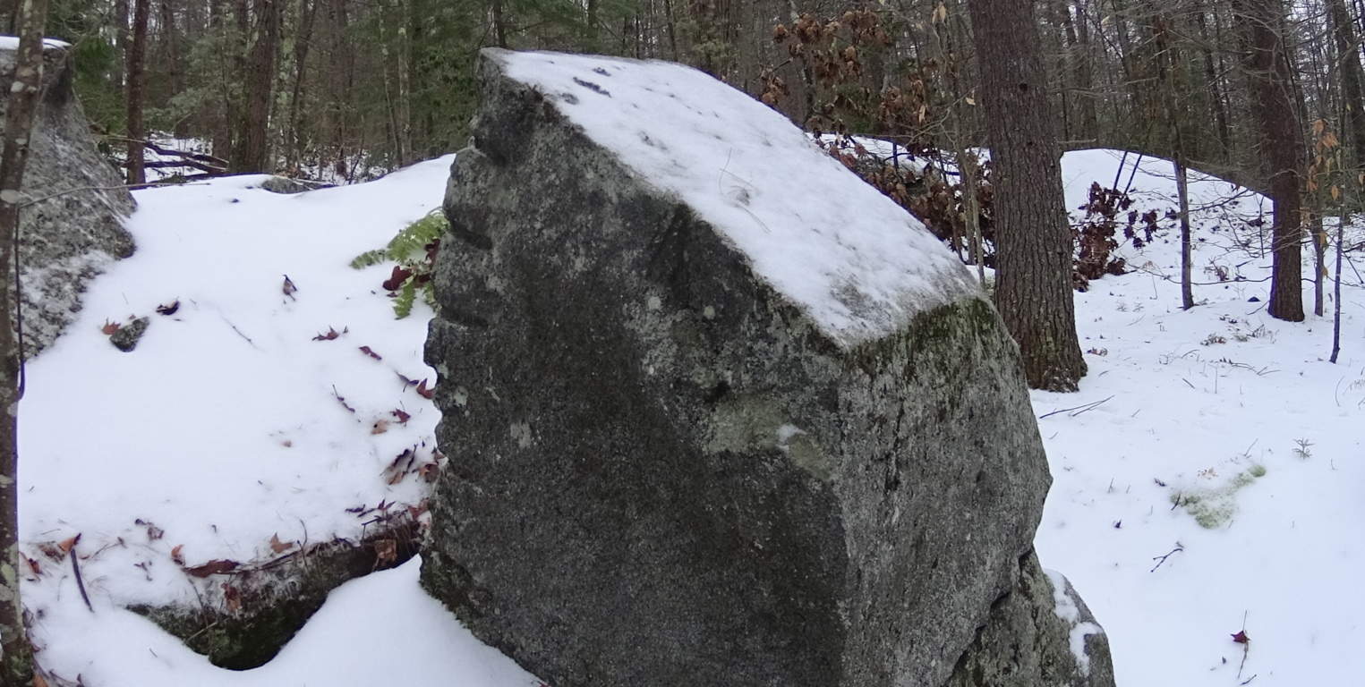
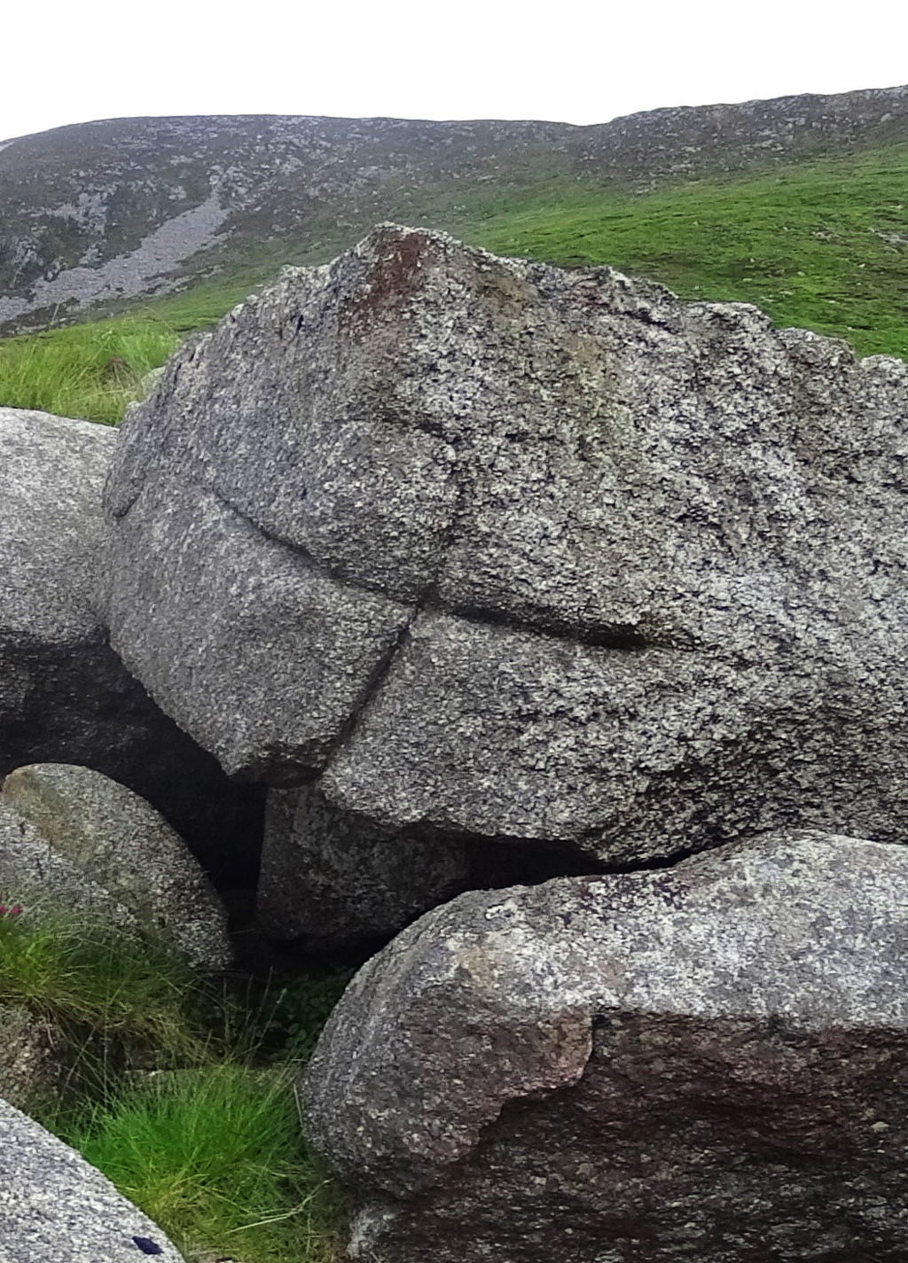 One possibility about the meaning of the “cross section” is that it is a type of utility that insures that if the section is cut, regardless of size, the remaining pieces will fit together if used to build other structures, such as stone-linings (“walls”), dwellings, or irrigation stones. Several examples of this “X” cross section from Watatic are shown here above, as well as one from the heights in the Mourn Mountains in Ireland (right). Before ascension on the trail begins, a classic megalith in the form of a smoothly split boulder, roughly 10 to 15 tons in weight, sits at the base of the mountain, like a gateway. The stone path literally passes straight through this massive cut boulder.
 If you stop to examine the area around this megalith, you will find several “cross-sections” waiting to be observed. Continuing, as you begin to climb, a beautiful old-forest glade of pines emerges, and the path becomes wider and rockier. For roughly a mile you will work your way through these pines. Interestingly enough, it is not until you reach about 1,400 feet in elevation, that a “stone-lining” emerges.
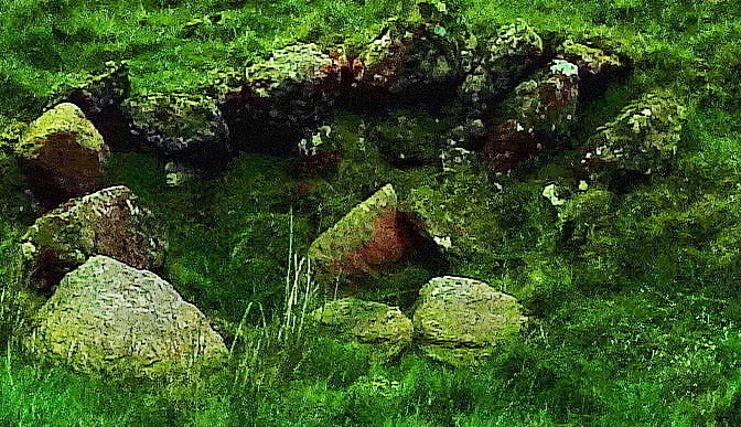
 This particular “stone-lining” is another strong piece of evidence against the idea that this type of feature is not a “wall” by any means. It became clear that this feature ran circularly around the dome of the mountain, like a crown on a head. No colonial farm has ever existed at the top of this fairly narrow set of circular porches at Watatic Mountain, where there is no elevated water reserve or pasturing possibility. The case for this being the work of a colonial farmer marking off his territory is illogical. It would be a triply arduous task for any laborer to first gather enough semi-megalithic size stones to lay a three foot high, two foot thick, pile of massive cut rocks around the full circumference of the mountain, at an elevation of about 1,400 feet.
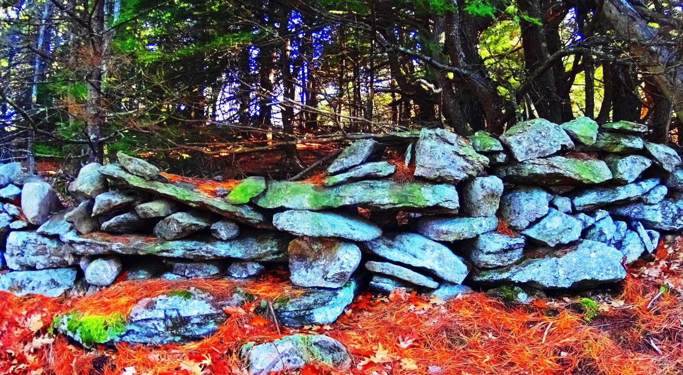 There are no signs that these stones were quarried at the top of Watatic, so they must have come from below. From below, after being crafted, piled, and gathered, the stones would have to be CARRIED UP, AND ALL THE WAY AROUND THE PEAK at an incline of roughly 60 degrees. If a laborer did manage to achieve this impossible feat, actually laying the stones, which weigh anywhere from 50 to 700 pounds each, it would take them a lifetime. Colonial living is an essay in practicality. Labors in Colonial times were conserved to efforts that yielded real sustenance, like digging wells for water, building barns for dairy and protein conservation, and clearing fields for crops. Building a stone wall for no reason around a mountain-side at 1400 feet, where there is no pasture, but only rock, would have been illogical, wasteful, and impractical to the point of preposterous. Something else is going on with these megalithic stone-linings. In places like Cavan Burren National Park in Ireland (Shown in green/right),
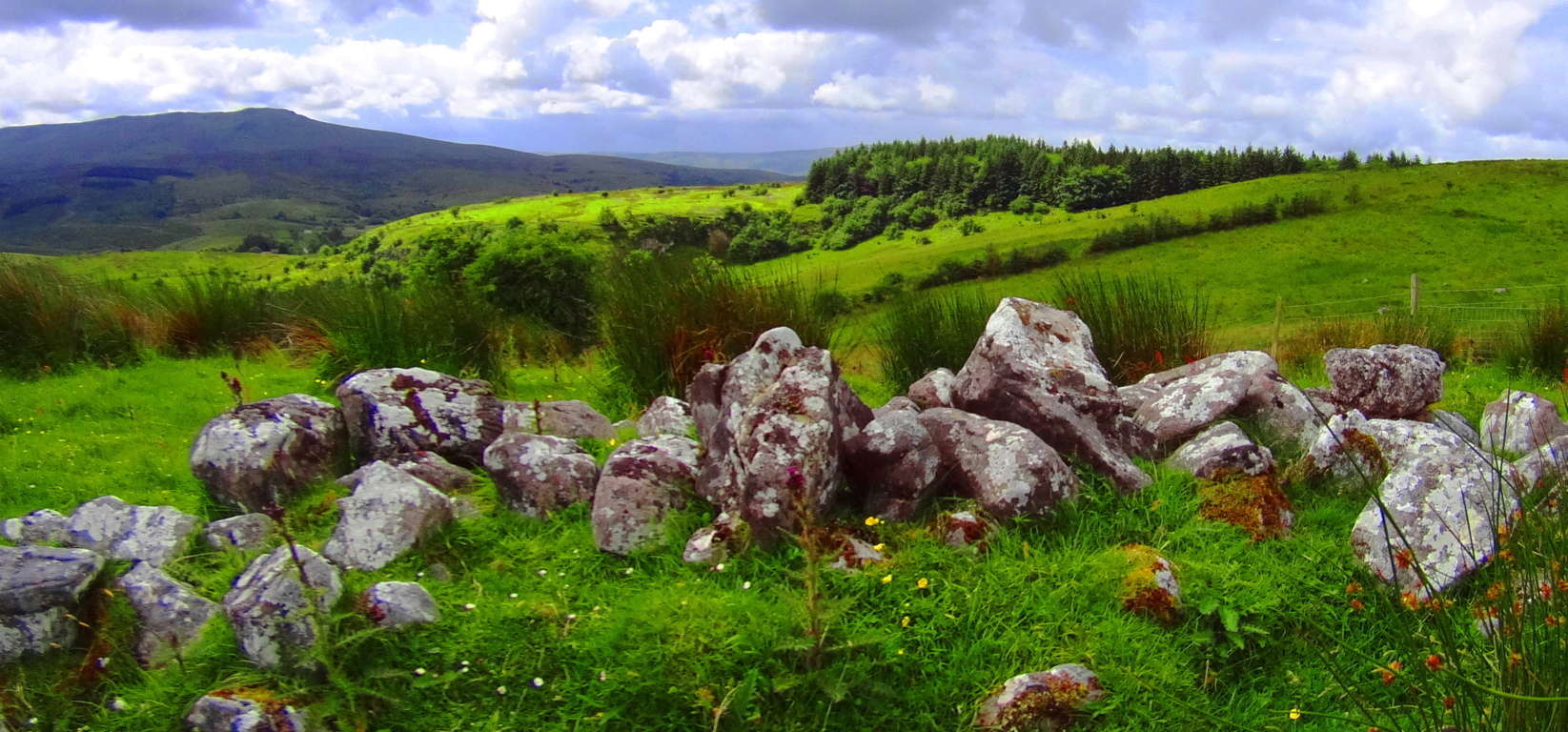 as well as the Blue Hills in south-east Massachusetts (Shown in red and orange, below/left), and the Mourn Mountains in Northern Ireland (Shown in green/left)
 , stone lining seem to be energy connectors, or containers of energy in certain spaces.
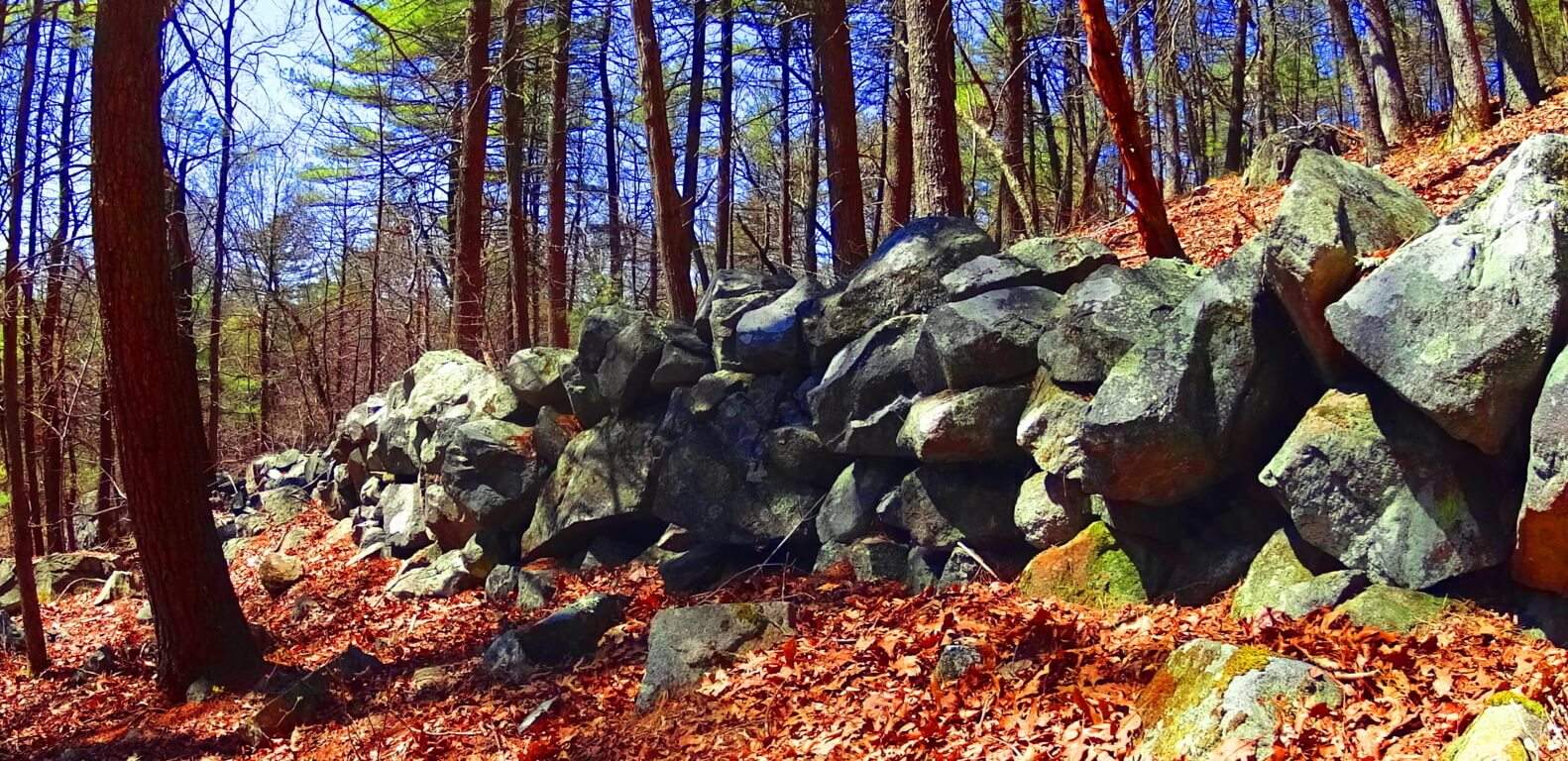 All of these linings are at significant elevations, and are not capable of containing any kind of herds; And this is what is happening at 1,400 feet on Watatic Mountain. Whoever set the stones in place wanted us to understand that the space created within the circle is a sacred energy center, charging the elevated dome of the Mountain with subtle energies. Continuing on again, after passing this 1,400 feet mark, your path will follow the stone-lining for about 100 yards until you cross-over into this special zone. At 1,650 feet there is beautiful Celtic style standing-stone just off to left of the path.
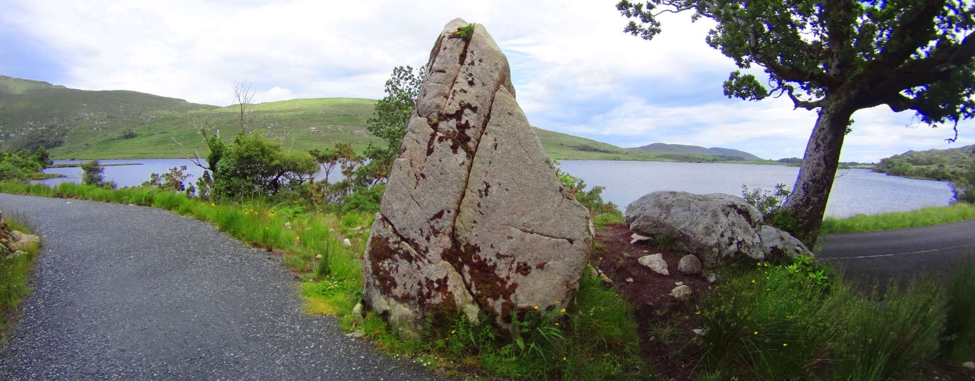
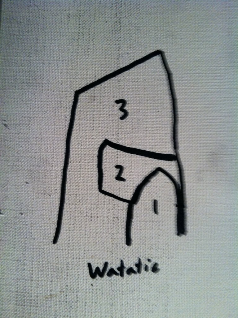
 It stands 6 feet tall, and perhaps 7 feet in width, with a distinctly cut ‘face’ supported by a rotund rear side.
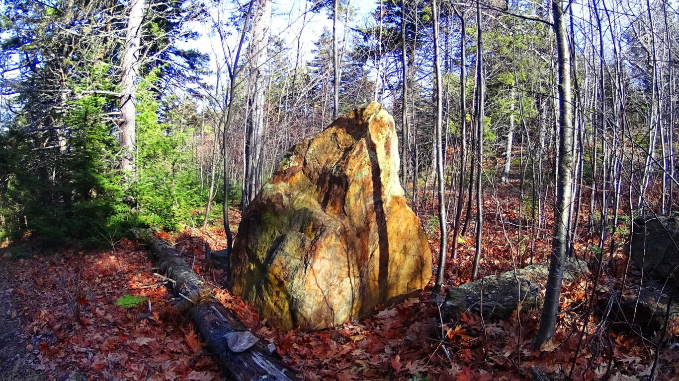 This exact style of “cut-facing with “rotund-rearing” can be found in a gorgeous diamond shaped, white standing-stone, along the castle trail at Glenveagh National Park in Ireland, (shown here in the next two images below).
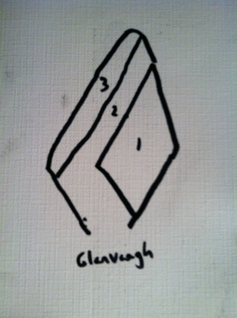
It is impossible to miss the distinctness of the “face” side with the “supporting rounded-rear side” in both stones, and therefor the similarity in craftsmanship. This is pretty solid evidence that the designers of these standing-stones had almost exactly the same knowledge about crafting them, as if they were from the same culture, although separated by an ocean. This is where the story of the Nephilim, as the first anthropological society on Earth, becomes relevant. Obviously the standing-stone at Watatic is so weathered by thousands of years of foliage layered on its distinct face, that it is practically camouflaged into the overgrowth, covering what looks to be pink granite beneath the grime, as opposed to the marble clarity of the Celtic stone, that has not experienced New England foliage. 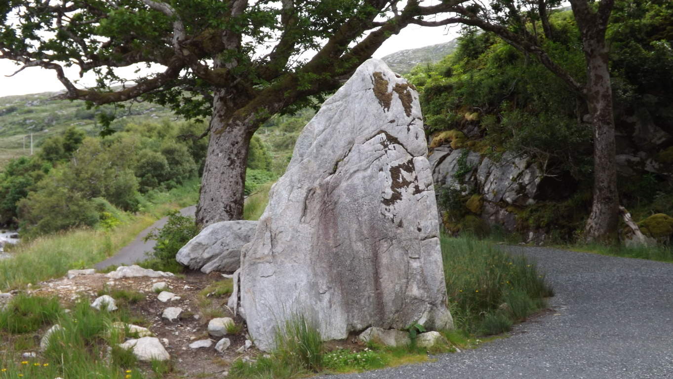 The standing-stone indicates, especailly at such an elevation, that this was once an incredibly endeared and valued space to whoever inhabited it. Finally, a quaintly cut-stone staircase climbs up to the last portion of the heights.
 Here you will arrive at a grand porch with a 360 degree view. The rocky trail continues to a larger secondary porch, 50 yards south, lined with pines and rounded granite floors.
 It is well worth the effort to reach the top. Watatic is an essential “small mountain” experience in Massachusetts, literally crowned by ancient megalithic stones. Take a day and see for yourself, you won’t be disappointed.
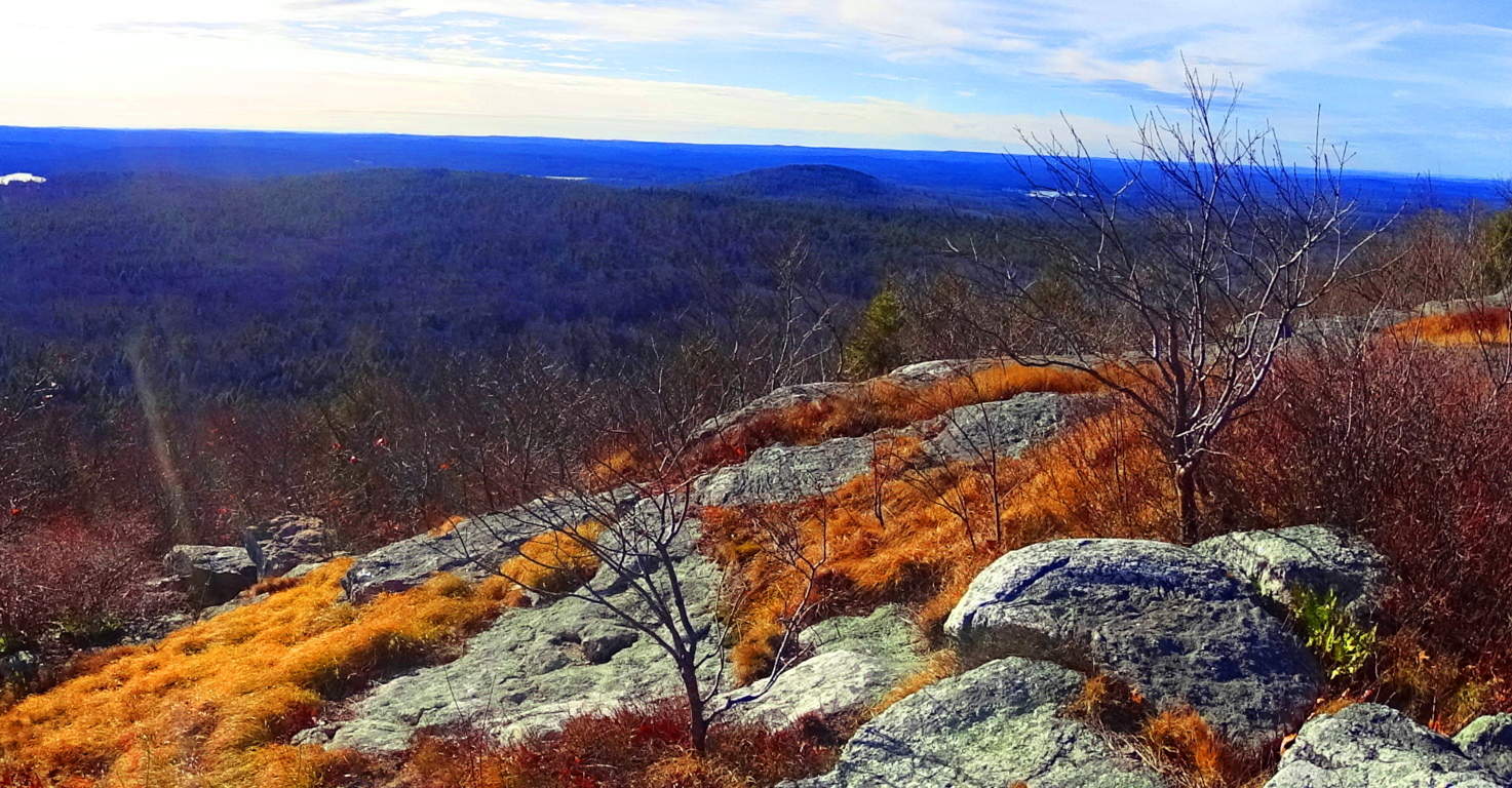
The Burren
 Location: County Clare/Coastline/ Cliffs/Mountains/South of Galway
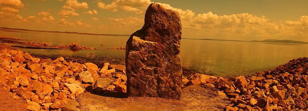
Standing Stone/Salt Hill Beach/Galway: Launching point for The Burren
Note: It is a beautiful thought that some places in the world are simply known as ‘regions’. The Burren is every bit a national park as any of the existing national parks in Ireland, and yet it is simply a region. No modern organization monitors this area overall. It is sustained by the endearing love of the Irish generations that have lived here since Celtic times. These are the people that remained through the Medieval-to-Colonial British incursions, and The Famine, and reveal an incredibly deep connection. A single sojourning through this striking landscape is all a hiker needs to understand this connection.
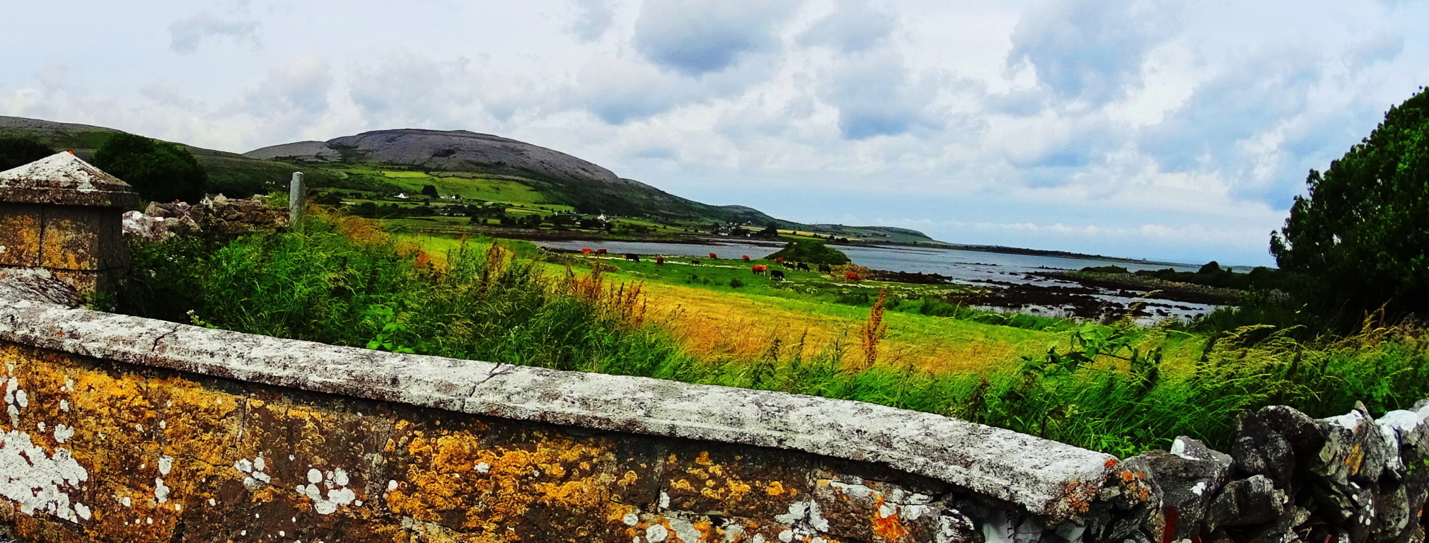 The roads and hills are open to hiking and climbing, as well as designated pathways. Make your way to the entry points as best you can by researching, exploring, and engaging the people of the area. To begin, the N18 highway runs south of Galway and connects to N67, which flows into the dimension that is The Burren. The gateway to this dimension is Dunguire Castle, perhaps the most beautiful in all of Ireland.
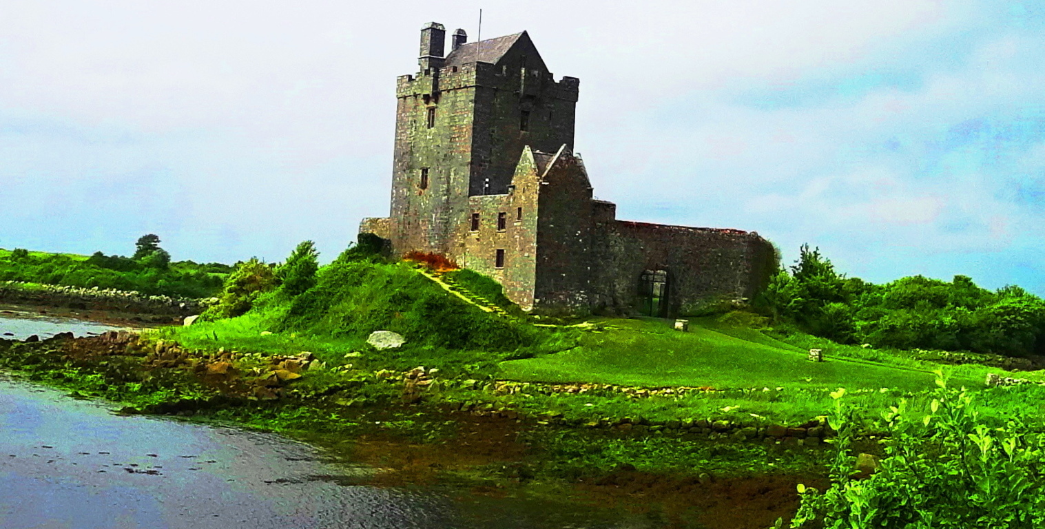 Embraced almost entirely by a bay that runs out of the harbor town of Kinvarra, Dunguire looks to be floating on a small island, slightly separated from reality.Dunguire’s grounds have pathways around the castle, and the courtyard is also accessible. Feel free to park in Kinvarra and walk a scenic mile to Dunguire’s 15th century gates. Kinvarra is the pivot-point for the turn westward, around the edge of the bay, and into the enchanted zones.
 In this place the small caps of the mountains are covered in white stones, with rock-stricken hillsides that are the color of the moon.
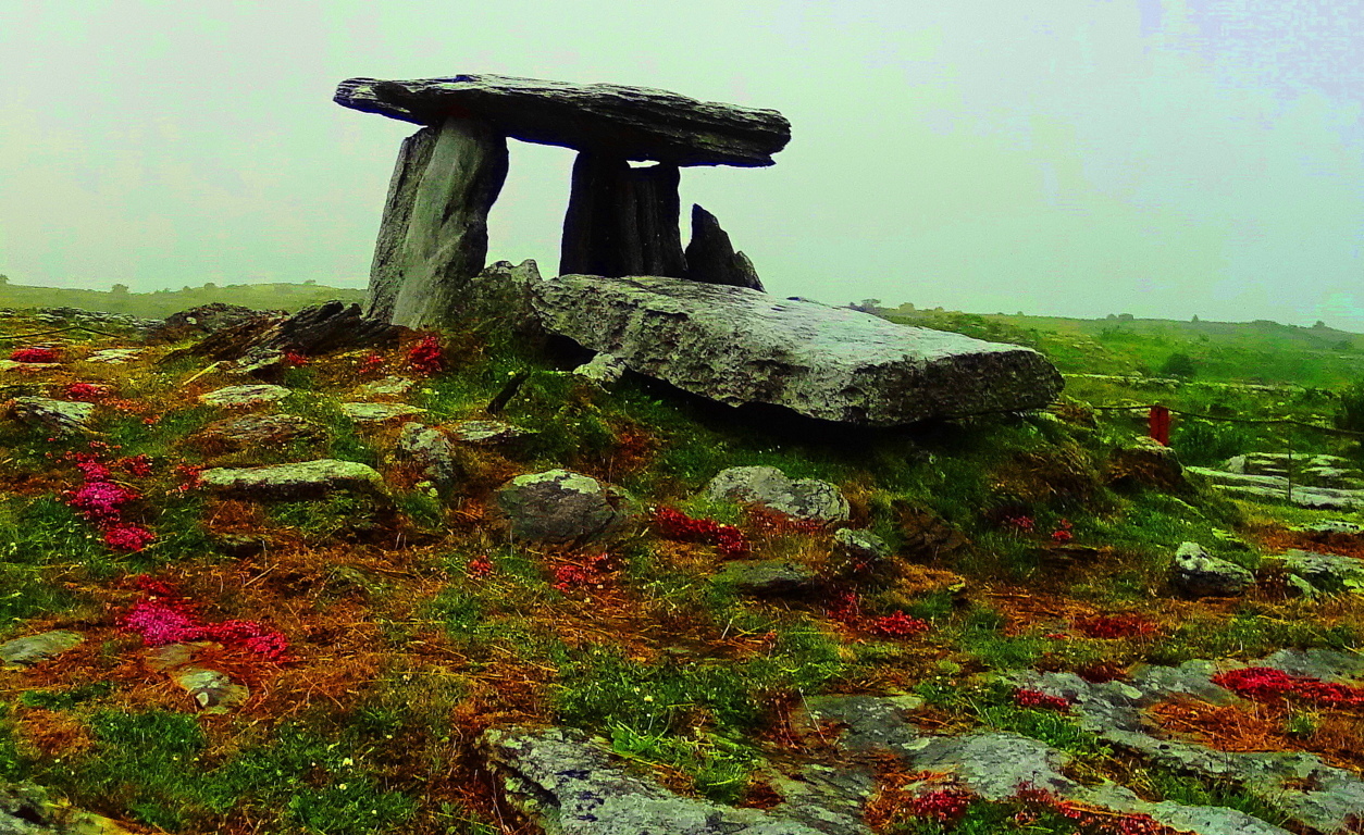 These undulating hills hide incredible monuments intertwined with the stone-walls and hedges. The Poulnabrone Dolmen has sat 17 miles southwest of Kinvarra for over 6000 years, and is the most iconic Dolmen in the world.
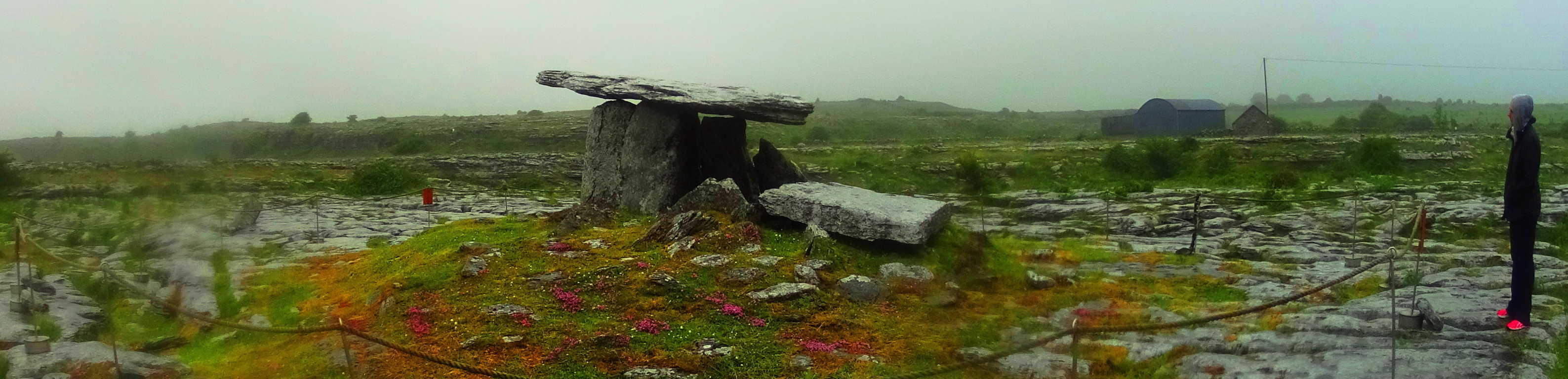 This iconography is due to the otherworldly context of the megalith, surrounded by free-sitting boulders in the peripheral distance, and supported by smoothly grooved rows of rock beneath it. It looks to be the very crossroads of heaven and hell. At a glance, it becomes totally understandable as to why they call these Dolmens “Portal Tombs”, meant to send the spirits of Celts to the stars. The 6 ton capstone, which is placed six feet above the ground, looks like a stone-satellite for receiving messages from the solar system. The Poulnabrone Dolmen has a similar look to the Gortnavern Dolmen in Donegal (Pictured below/left),
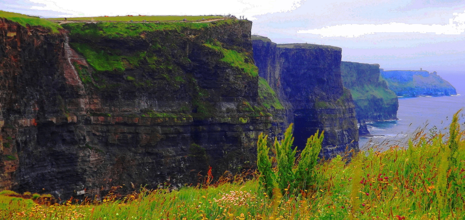
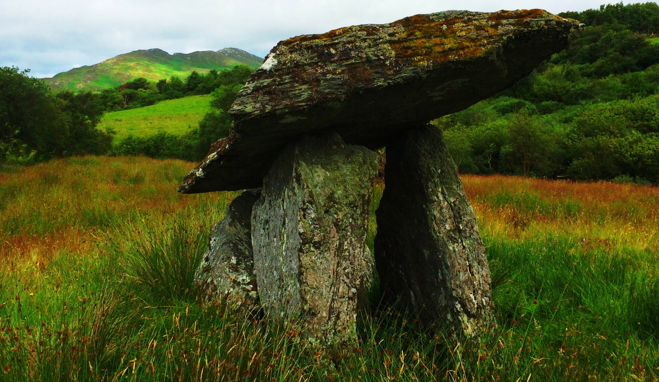 far to the north, with a massive but slim capstone and similar supporting stones. Other Dolmen’s in various Celtic regions abroad sponsor much larger megalithic features, as well as different styles. This Dolmen can be found just off the R480 road, which is a classic country-drive with tunnels of tight green hedges. Be prepared. The best regulated hiking trail of the area is, without any doubt, the Cliffs of Moher. A Medieval tower sits at the northerly edge of the excellent trails that run along the dramatic Atlantic cliff, which drops over 700 feet below. These trails run for about 6 miles along the ledge, so it is just over a half day of hiking if you so choose.
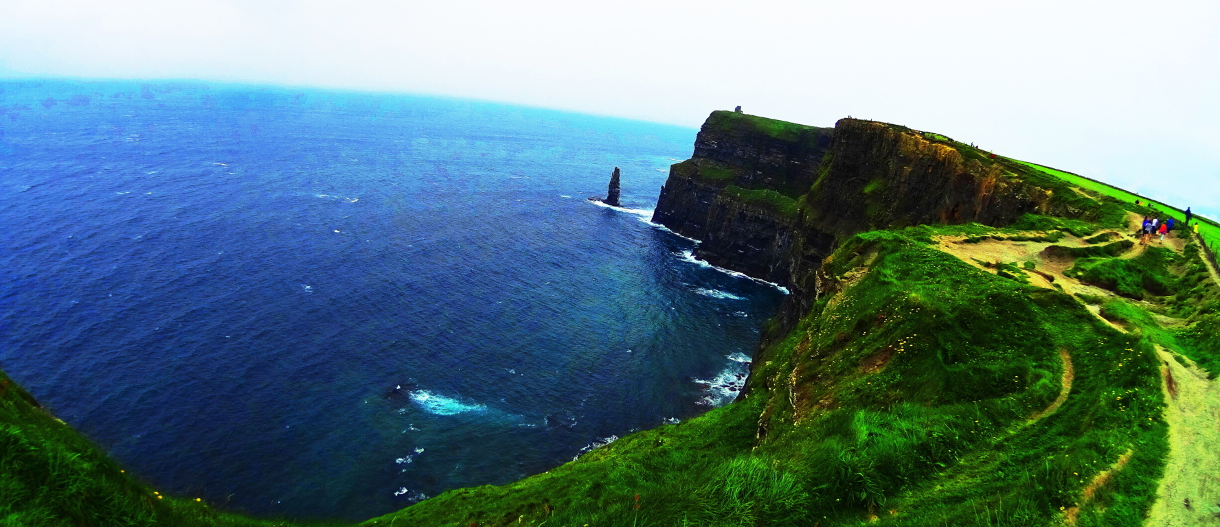 The coastal view and the towns to the south are epic in this area, so take your time on a fairly level trek. All throughout the country side are thatched cottages and ancient abbeys. Perhaps just as haunting as these ancient places are some of the abandoned cottages of families that could not ride-out The Famine, along the country roads.
 This is a place where hikers and photographers should spend more than a few days. The Burren has that “beyond time” capability to make a traveler forget about the outside world. Legendary author J.R.R Tolkien lived in, and utilized, this landscape at times, along with places in Wales and England, for the inspiration of the descriptions of the magical Shire of his stories. Amazingly, after all this wonder, it is yet, and still, simply a region. This is perhaps the best reasoning as to why seeking and finding is sometimes necessary for true adventurers, where many miles outside of the commonly ‘commercialized experience’ of domesticated parks, real indigenous surprises still exist in the regions of lessor known places.
Bear’s Den
 Location: New Salem, Massachusetts
1
2
3
4
5
Note: Among the initial benefits of hiking… the quiet… the calm… the fluttering of the leaves above, the splashing of streams below, are more miraculous treasures waiting to be discovered. Bear’s Den is one of the most astonishing example’s of this possibility in New England, and even the world. Located just off a quiet road of a small unassuming nature preserve in New Salem Massachusetts, Bear’s Den sits ready to reveal some of the most incredible things a forest can offer on either side of the Atlantic. To begin, tucked into a small gully just beneath the initial trail is an exquisite example of an ancient stone-dwelling.  This structure has distinct dry-laid outer walls up to 7 feet high, with unique stones that are each deliberately placed and crafted in an amazing way.
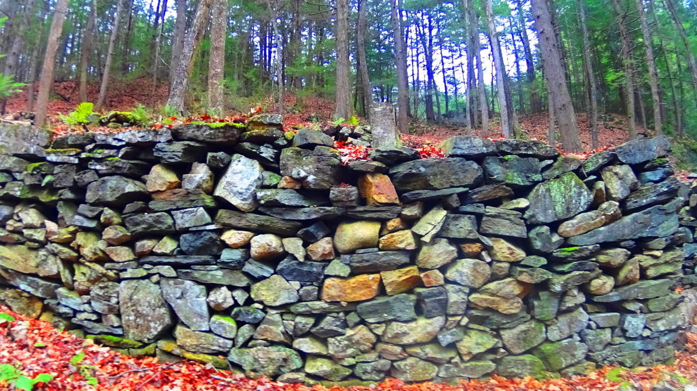 There is an entrance way leading to a single passage that opens on the interior to a leveled-off, stone-supported, bed space.
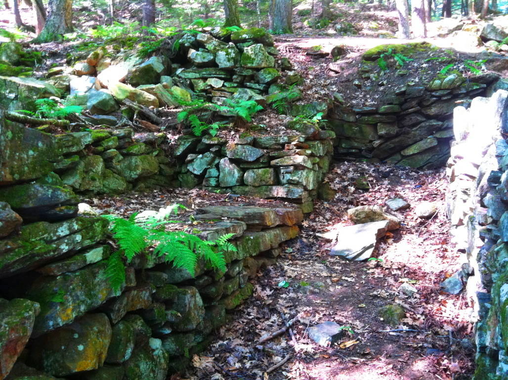 When entering the chamber you feel like you’re in someone else’s home, like a Neolithic apartment for one. There is 4 ton ‘squared’ granite piece sitting high-up on the exterior side wall, across from the bed space that looks very much like a stylistic statement made by the builder. Through sheer size, this megalithic stone says: “Look where I can put this gigantic stone!” This certainly doesn’t look like Colonial work of timely practicality, which usually involves simple cobble and brick, and avoids megalithic size stones. Native Americans were not interested in moving megalithic stones either, or building stone dwellings in north-east America. In terms of historical context, it seems that this structure somehow would’ve been here before the natives arrived, and is not the first instance of ‘megalithic culture’ at the birth of antiquity. This coincides with the claims of native Peruvians, for example. who blatantly claimed that the megalithic structures, built high in the mountains, were there well-before their ancestors arrived.
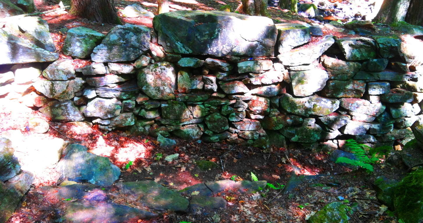 The combination of difficulty, along with the additional craftsmanship of this stone, gets our undivided attention, which is probably the point! To set in place, and perfectly level, a 4 ton granite block that sits 6 feet above the supporting smaller stones, is outstandingly bold to say the least, and incredibly difficult. It’s as if the builder wanted more of a challenge. People in New England that call structures like this a “colonial root cellar” are mentality and logically lacking. It’s the equivalent of calling Stonehenge “just a bunch of big rocks”, when we know it’s obviously so much more. And the intrigue at Bear’s Den just intensifies from here. From the stone-dwelling, follow the trail to the top of the knoll to the north.
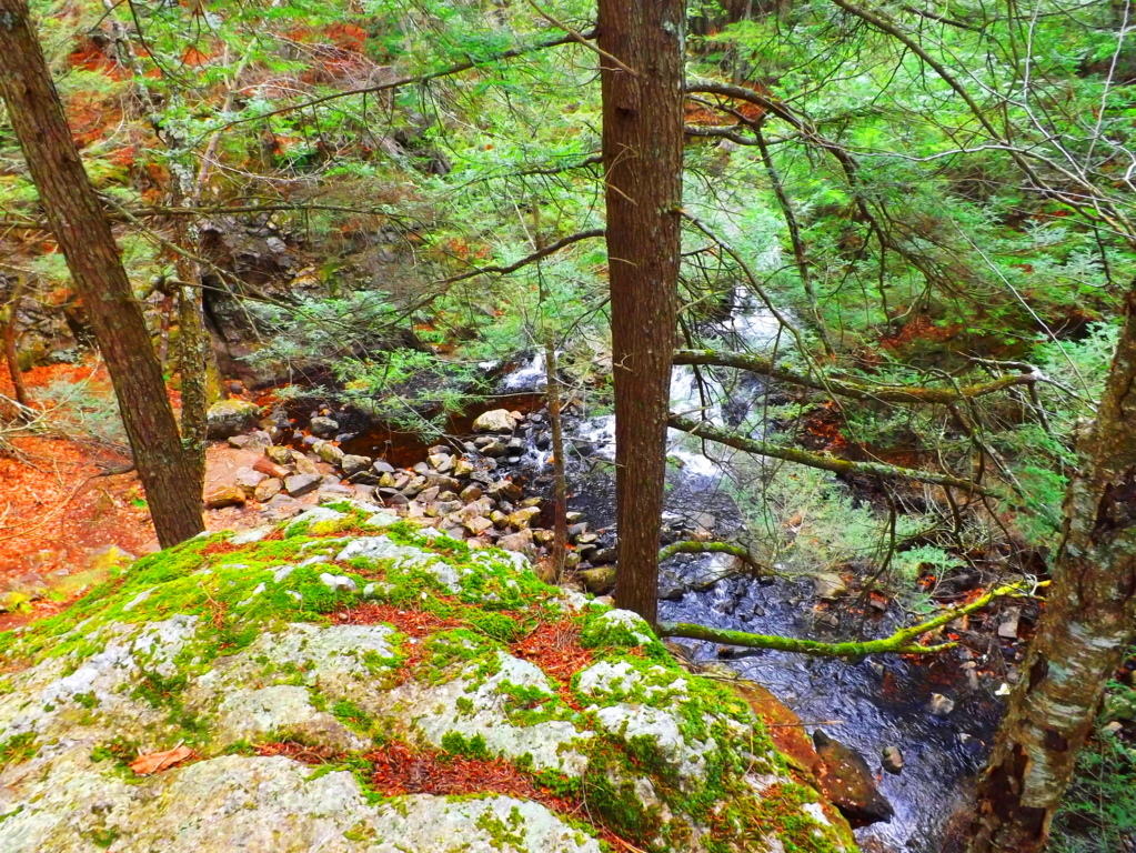 Free-sitting boulders at the top of the knoll are crafted, creating an entrance way and designated view of the waterfall on the other side. Two specifically elevated and leveled stone porches sit facing the waterfall at an intended height from about 25 yards away. What you are about to see is exquisite. The first glance of this picturesque waterfall from this elevated stone-porch reveals multiple features. The stream is split beautifully by a massive stone facade. The water that flows to the right of the main facade funnels through a specifically cut ‘spout’ down into an incredibly crafted leveled pool. This is where the scene begins to become surreal, mathematical, and incredible. Before continuing, take a look at the close-up image of the right side of the ‘funneled waterfall’ (2nd image below) and see if you notice anything unique about it. It’s impossible to miss…
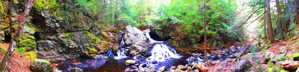
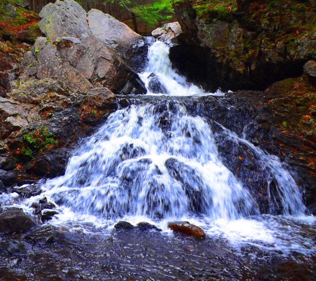
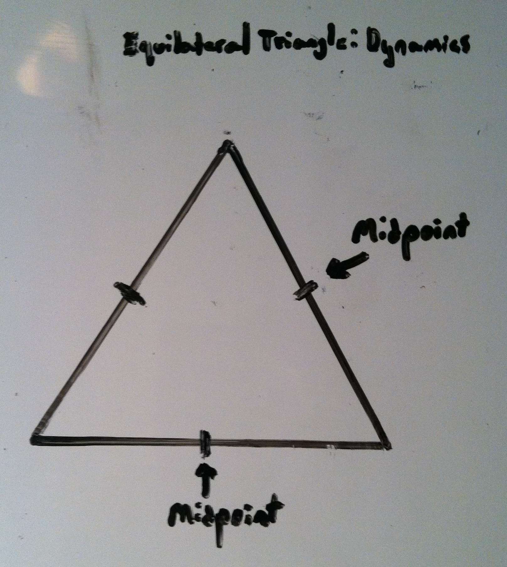
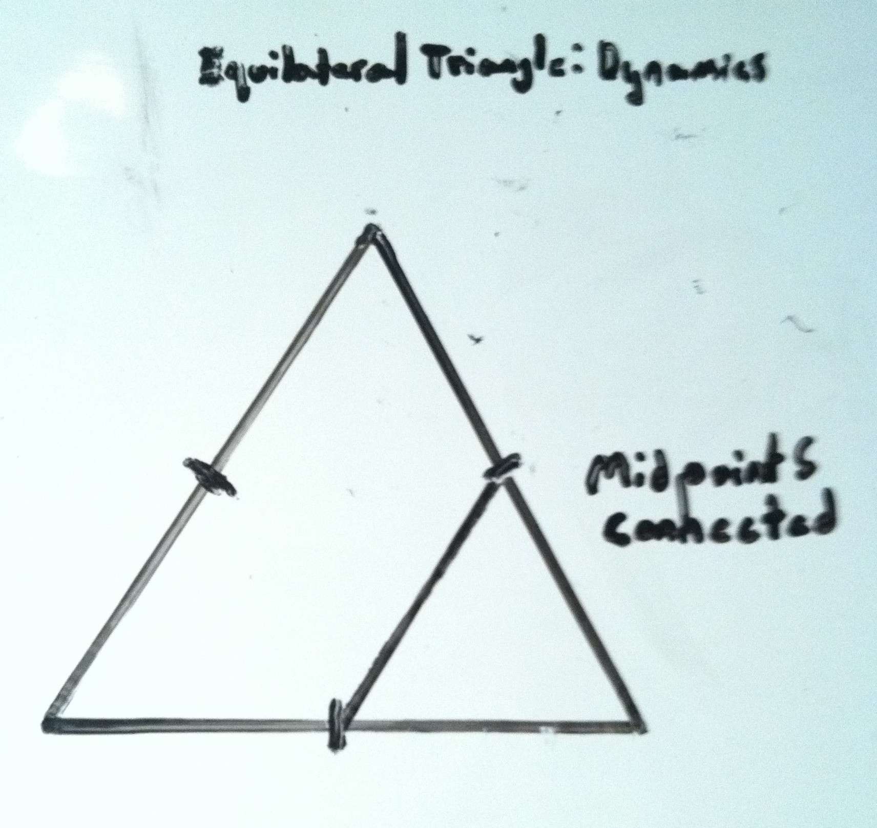
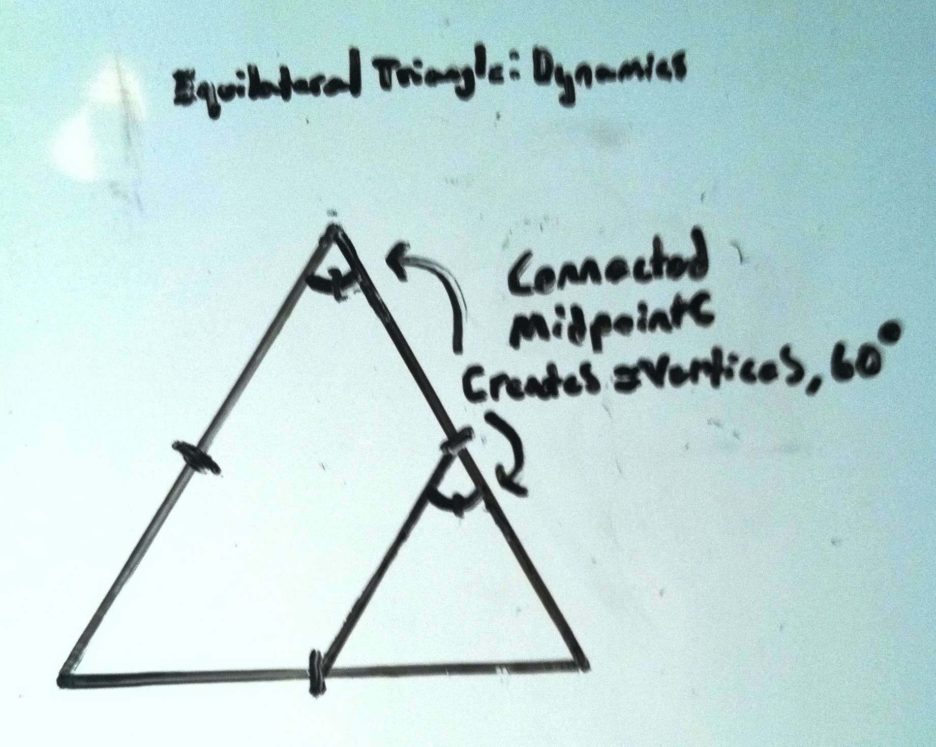
The Emblem Stone: Along the inner line of the perfectly leveled pool receiving the water from the funnel, is a beautiful granite-cut emblem of an equilateral triangle, each side being about two feet long, but looking smaller from a distance. Equilateral triangles DO NOT OCCUR IN NATURE, so we immediately must begin to wonder, who could have done this, and why? If you look closer, there is also a line inside the triangle clearly connecting the midpoints of two sides. A line that connects the midpoints of two sides creates an angle of 60 degrees.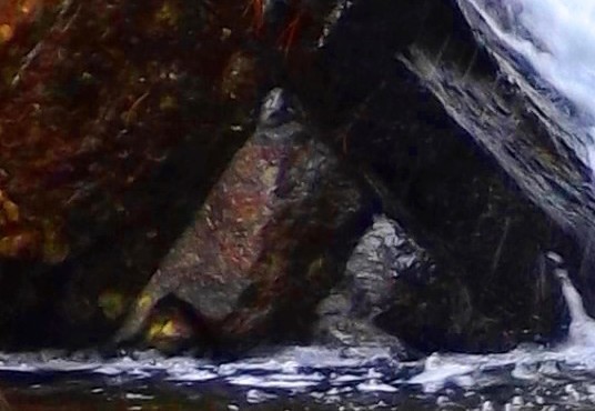
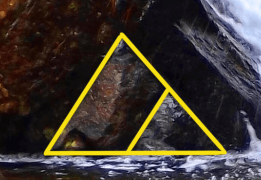 It appears that this emblem is depicting a specific geometric relationship. (Shown on the right) All of a sudden, the waterfall too, is an anthropological site.
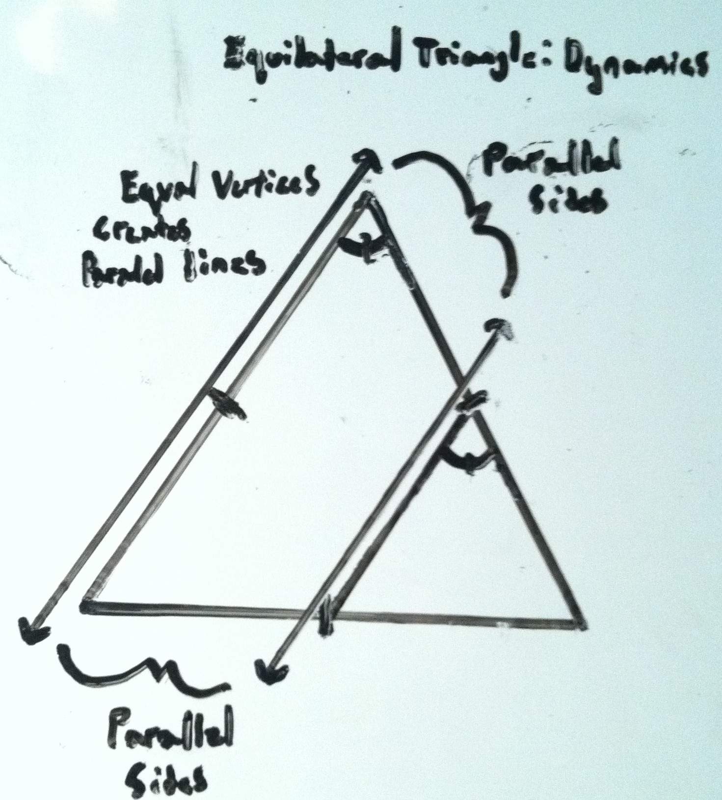
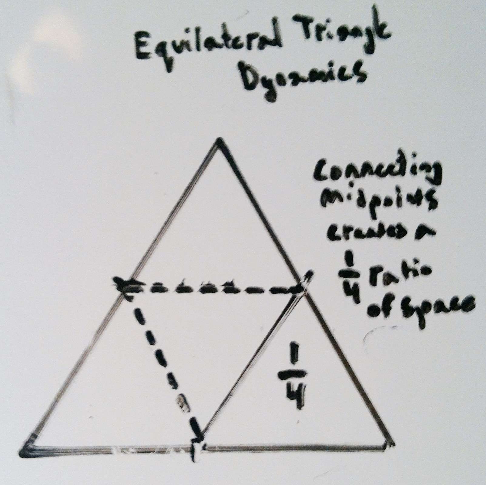
Simple Geometry: (Please look to the diagrams 1-5 above to see the proofing of these ratio’s and parallels): At this time a few simple geometric explanations are required which only take a moment. Due to the midpoints being connected within the triangle, the vertices of the smaller triangle become equal to the vertices of the larger outer triangle, at exactly 60 degrees. Further still, since the vertices of both triangles become equal, the sides of both the larger and smaller triangle therefor become parallel. When these relationships are proven, the smaller triangle is revealed to be exactly 1/4 ratio of the entire figure. This is absolutely astonishing. Logically we must accept a few things at this time. First, it should be understood that whoever etched this emblem did so in granite, and for a reason. We have to conclude that the designer absolutely intended for us to notice it. In fact, the only guarantee that it would be noticed, is to etch it in granite. Second, the specific geometry of the emblem is a message, a coded stone, informing us that the designer was obviously well aware of Sacred Geometry. Third, if someone from antiquity is leaving us a coded emblem with specific geometric relationships, it demands our utmost attention, and we should be adamant to observe any other relationships taking place, relevant to this emblem.
The Funneled Waterfall Parallel: It is logical to follow the lines of the parallels that have been established by this emblem to see if there is any further connections on the waterfall overall. If we continue the line of the left side of this coded emblem, we see that it connects DIRECTLY to another crafted feature. Continuing along this exact line is a crafted stone funnel where the water is harnessed specifically to a single focal point. This exact line is becoming a longer parallel. 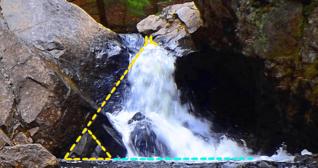 You can see the distinct whiteness of the water blasting out of the funnel. At this point something astonishing is beginning to emerge. The possibility that the ’emblem stone’ is a coded statement for relationships relevant to the entire waterfall is becoming possible. If this parallel line extends to a specific point on the larger structure, is it possible that this line will have a matching larger parallel on the other side of the waterfall, just like the lines of the emblem? Is it possible that another larger triangle can be established relative to this right-side portion of the scene? Let’s continue to try and find features that fit the ratios and angles. If we continue to implement the information the emblem conveys, from this top funnel point we can implement a 60 degree angle, and draw a line downward at this specific angle. We will then continue to draw that line down to a point where we can implement another 60 degree line at the base. If we do this, another perfect triangle emerges, depicting an outline of the ‘funneled-side-waterfall’ on the right-lower side, exactly as depicted in the right-lower side of the emblem stone.
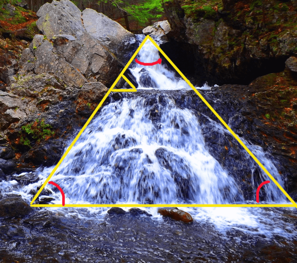 From here, if we want to see if there is a ratio-appropriate parallel to the ‘funnel-waterfall-triangle’ on the 3/4 side of the scene, we need to step back to where we can see the entire picture again.
The Top Central Boulder: Returning to the leveled stone porch, we must look for a central point where a larger parallel line can converge, in accordance with the pattern on the emblem. Remember that the emblem depicts a specific 1/4th ratio for the smaller triangle within, therefor, a higher point in the 3/4ths section on the right should specifically exist. Let’s continue to look for this intentional designation. If we examine the upper-left portion of the overall waterfall, we DO see something specific. Looking down from the center of the elevated porch, directly below is a set of distinct stones that serves as a central bridge that connects the land across the stream with the granite facade. If we follow this line we can see that it directs our eyes straight ahead to the exact high-point on the massive frontal/main granite piece, where there is a distinct crease cut into the rock (double click o image to the right to look closer). Directly above and behind that crease is a free-standing boulder, placed centrally (circled at the top. in yellow).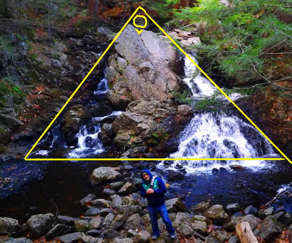
 It is certainly important to check these points of significance to ensure that they are not arbitrary. It appears that the aligned stoned bridge is directing us towards this specific boulder. If you cross this bridge, which is completely linear, and climb up to the cut crease, then make your way to the centrally placed boulder behind the facade, and turn around, there is something spectacular we are intended to see.
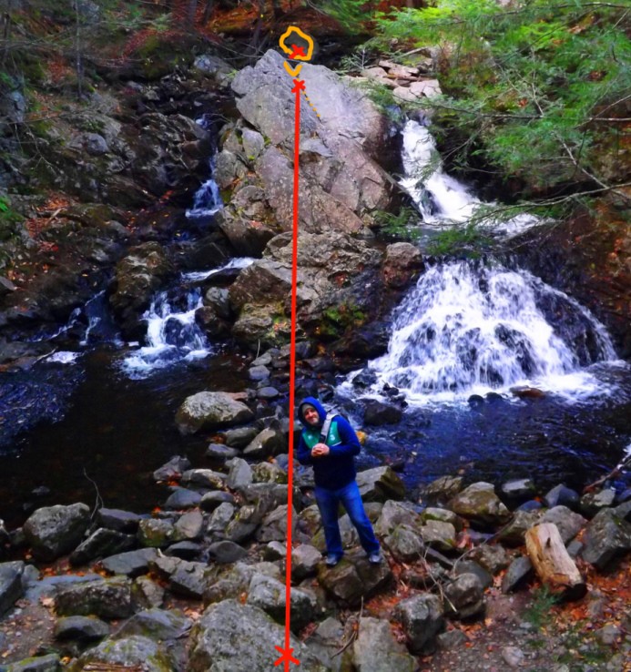
The Aligned Rear Altar: Here we see what looks to be a type of “water-altar” embedded behind the uppermost granite facade where the crease is. The cut line of this uppermost crease is even more distinct from the back side, revealing an exact cut that extends as an incision deep into the granite at a 45 degree angle.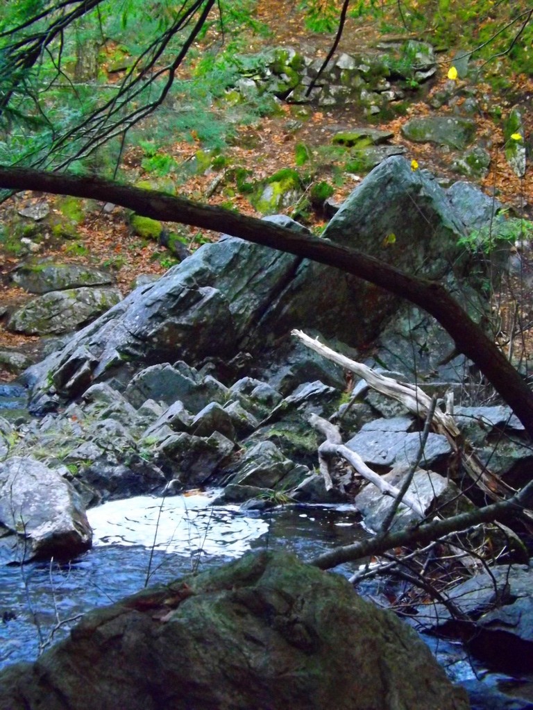 Looking back now from the center of the boulder, through the crease, back to the elevated porch, is a perfectly straight line, as well as a perfectly leveled line (Image marked below, left). The alignment, symmetry, AND elevation, are all absolutely exact. This rear section is obviously another type of ‘alter’ intended to be found by use of the information given to us by the emblem. Along the line of the ‘high point crease’ is a circularly cut whirlpool, with a back drop of smaller stones with little incisions that follow the 45 degree lining of the top most crease. These are blatantly angled cuts in solid granite. This is also the exact spot where the water divides into two sections, cascading down to the left and to the right onto the frontal facade (Image to the right). As the high point of division for the stream, it is further justification as an identified high point to the main frontal facade. All of this information serves to reveal the free standing boulder behind the uppermost crease as a central high point, intended for us to discover by the efforts of the designer of this waterfall. With this important piece of information, we can go back to the elevated porch on the frontal side of the waterfall, and utilize the ‘top boulder’ as our fixed point for the parallel line we are hoping to find, which will logically coincide as a parallel with the ‘funnel-waterfall-triangle’ line on the more minor lower left side of the overall facade, just at the top corner and the mid-line corner coincide on the emblem.
The overall waterfall and the emblem are the same: If we extend the ‘funnel-waterfall-triangle’ lines, at the angle of 60 degrees indicated to us by the information within the ’emblem stone’, this line will run straight to the peak of the ‘top boulder’. It all comes together from here. The outer line connecting the ‘funnel-waterfall-triangle’ to the specific point of the ‘top central boulder’ is enough information to allow us to complete the picture. 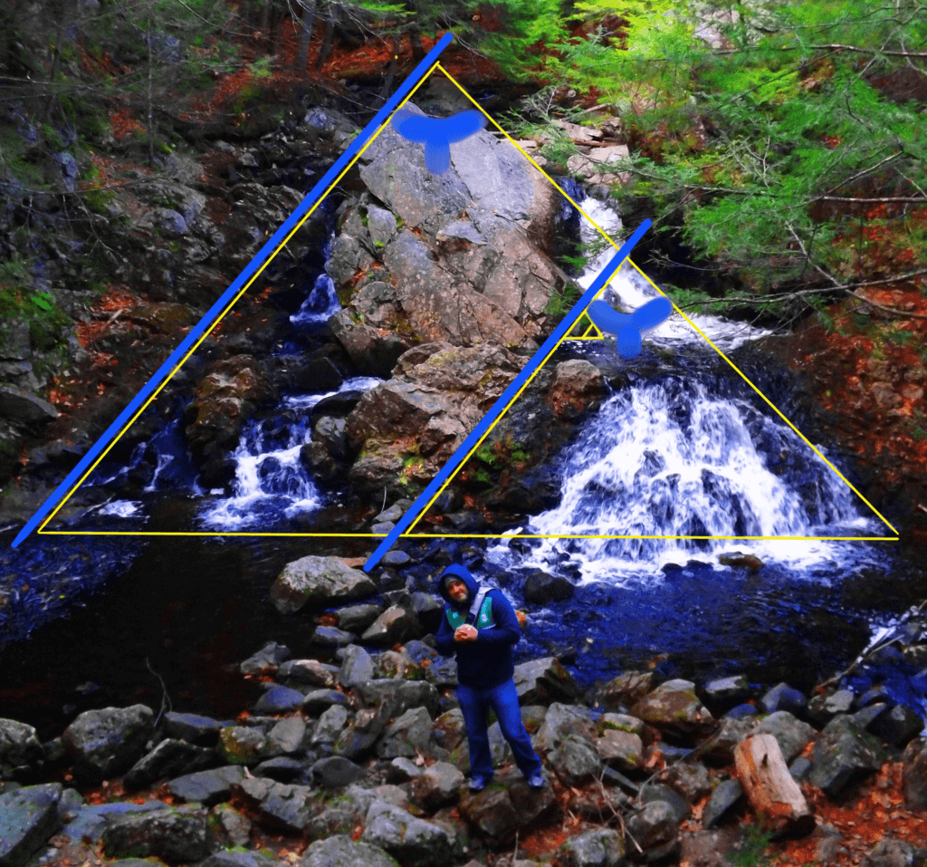 If we again use the 60 degree angle implied by the emblem stone, we can now draw the parallel line we were searching for, that coincides with the ’emblem-to-funnel’ line. We draw the line as a parallel from the ‘top boulder’ down, and the picture begins to emerge in full. The parallel lines are in specific ratio as well, so it becomes impossible to miss. If we match the 60 degree corner of the established ‘outer right-side line’ on the right-side extremity of the waterfall, we can define a 60 degree corner on the left-side extremity and run a base line from one end of the fall to the other. Here we see that THE RATIOS OF THE ORIGINAL CODED EMBLEM EMERGE AGAIN IN THE OVERALL WATERFALL (displayed below). We now see, by definition, that the 1/4 ratio portion of the overall triangle is the ‘funneled waterfall triangle’ with the ‘leveled pool’ on the minor right corner. It’s a perfect fit. What we have discovered is that the ’emblem stone’ is nothing less than an embedded, ratio-specific ‘keystone’ that opens up the possibility of comprehending the entire picture.
Mystical Beauty: There are so many question that come from discoveries like this. Who would have the ability and knowledge in antiquity to create an engineered, ratio-specific, waterfall from cut granite? This just doesn’t coincide with the evolutionary depiction of history, where humans are depicted as primordially primitive. Perhaps the builder was not entirely human? It’s not just the magnitude of understanding, its the ability to carry it out that’s really moving. The emblem shows us the mind of the engineer of this waterfall; That beautiful ideas can have a core principle, and be carried out into complexity by the consistency of defined ratios and principles. To do this in antiquity is earth shattering. It seems likely that the engineer of this masterpiece lived in, and also designed, the elegantly simple and beautiful stone-dwelling just over the hill. It makes sense. The stream flows from the waterfall, around the hill, straight to the dwelling, and beyond.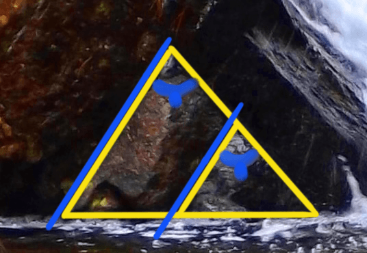
It is a captivating scene.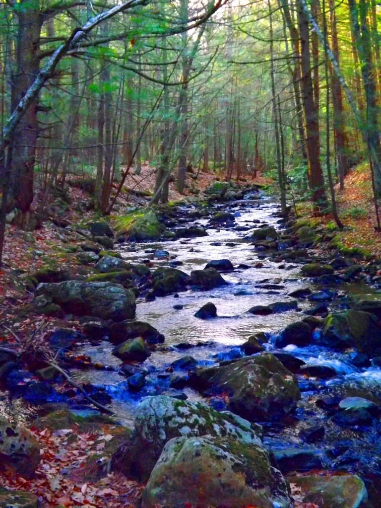 For a moment, picture a pristine Era at the beginning of Time, when the water was clean and drinkable. This area was carved-out as a place of pure joy and regeneration, perhaps in the very first Era. It is at least one of the oldest functioning engineered sanctuaries in the world. It’s haunting; where trails run along the river above the waterfall and below, through the forest and back to the stone-dwellingl for a 2.5 mile loop.
The Equilateral Triangle: The equilateral triangle is a feature that actually shows up in many New England forests in several different ways. In my personal explorations for content for Stonestrider.com, I’ve seen large granite cuts, subtle small granite pieces on mount Watatic, Massachusetts, with holes somehow drilled smoothly into the exact center. and massive granite slabs in deep woods with 60 degree quartz stripes across the face (bottom images). On my way out of Bear’s Den on my most recent visit this September, just down stream from the waterfall, I discovered another cut equilateral triangle, this time laying right beside the boulder it was cut from (green stones on the lower left).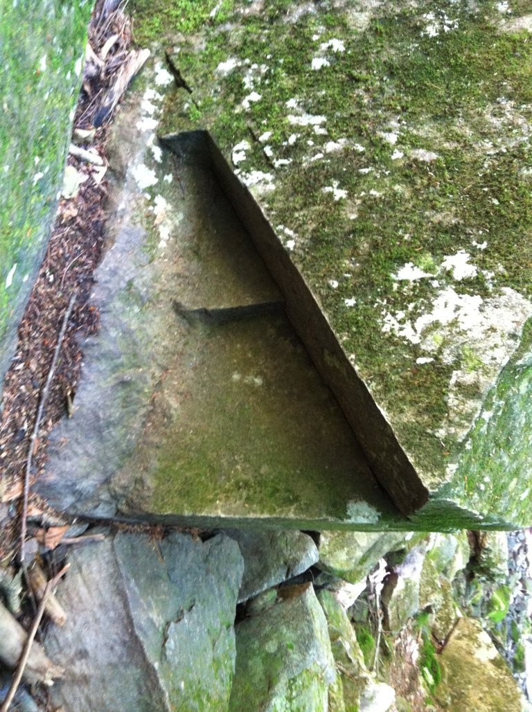
 This is Neolithic meme in New England of incredible and profound significance. The culture that appreciated this specific geometric shape engineered it into their lives, in their work, and in their hearts. The ancient Israelite immortalized the equilateral triangle in their designs of the Ark of The Covenant and later in the Temple, as instructed by Ashem (Yahweh,God). A functional living monument dedicated to this shape conveys a message across the Ages, which is that the builders were connected intimately with this divine principle. If you explore the forest and mountains of New England, as well as the Celtic high country, it is only a matter time before you discover this for yourself. Hope to see you out there.
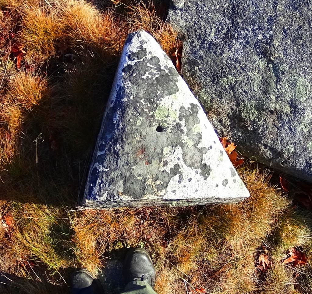

Betws Y Coed
 Location: Wales
Note: Betws Y Coed is a gorgeous Celtic hamlet nestled at the convergence of the rivers Conwy and Avon, 7 miles south-east of the great Mount Snowdon. The stone-cut architecture combined with the sounds of vibrant rolling waterways running parallel to the Central Green creates a vibrant energy that is an absolute relief to arrive at, if a hiking getaway is your goal.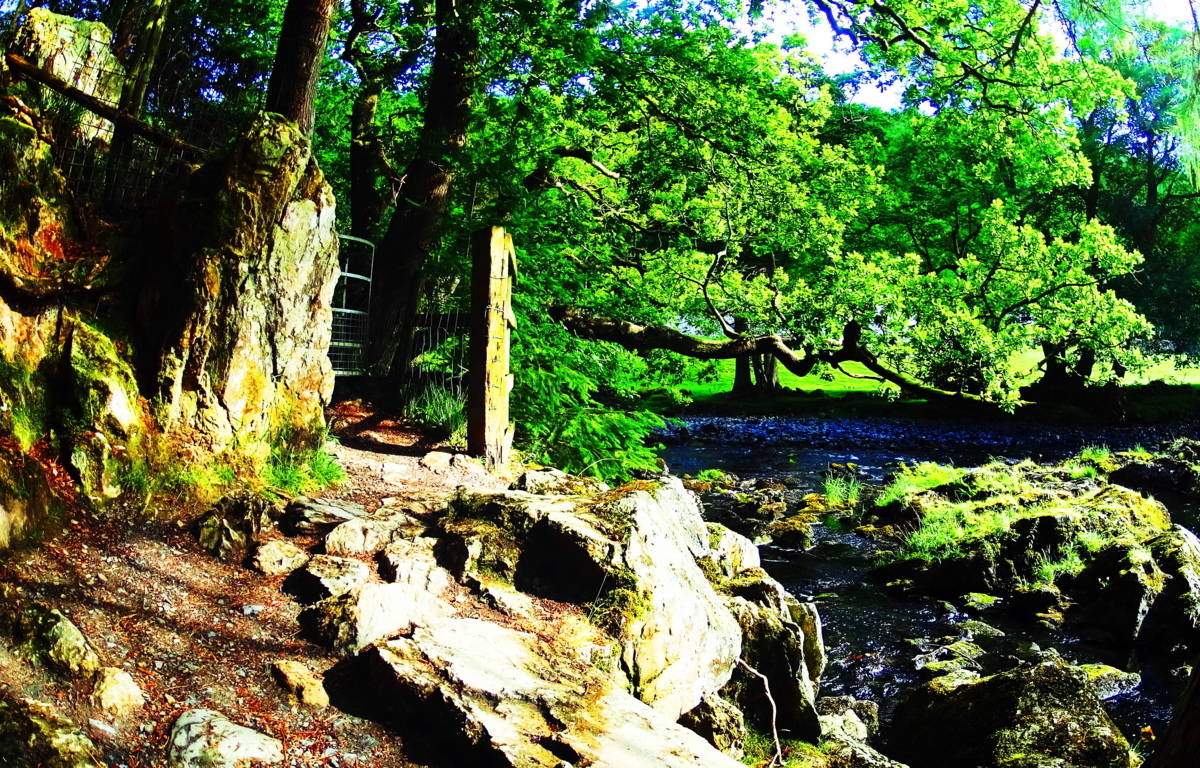 The entire region is a hiking paradise, where you can choose carefully which direction you would like to go during your stay. Within Betws Y Coed are elevated forest trails, riverside paths, waterfall drops, and countryside hikes, all from the center of town. Caves from the Neolithic period, carved out of the mountainside, appear along the trails, and have an amazing presence as you pass by.
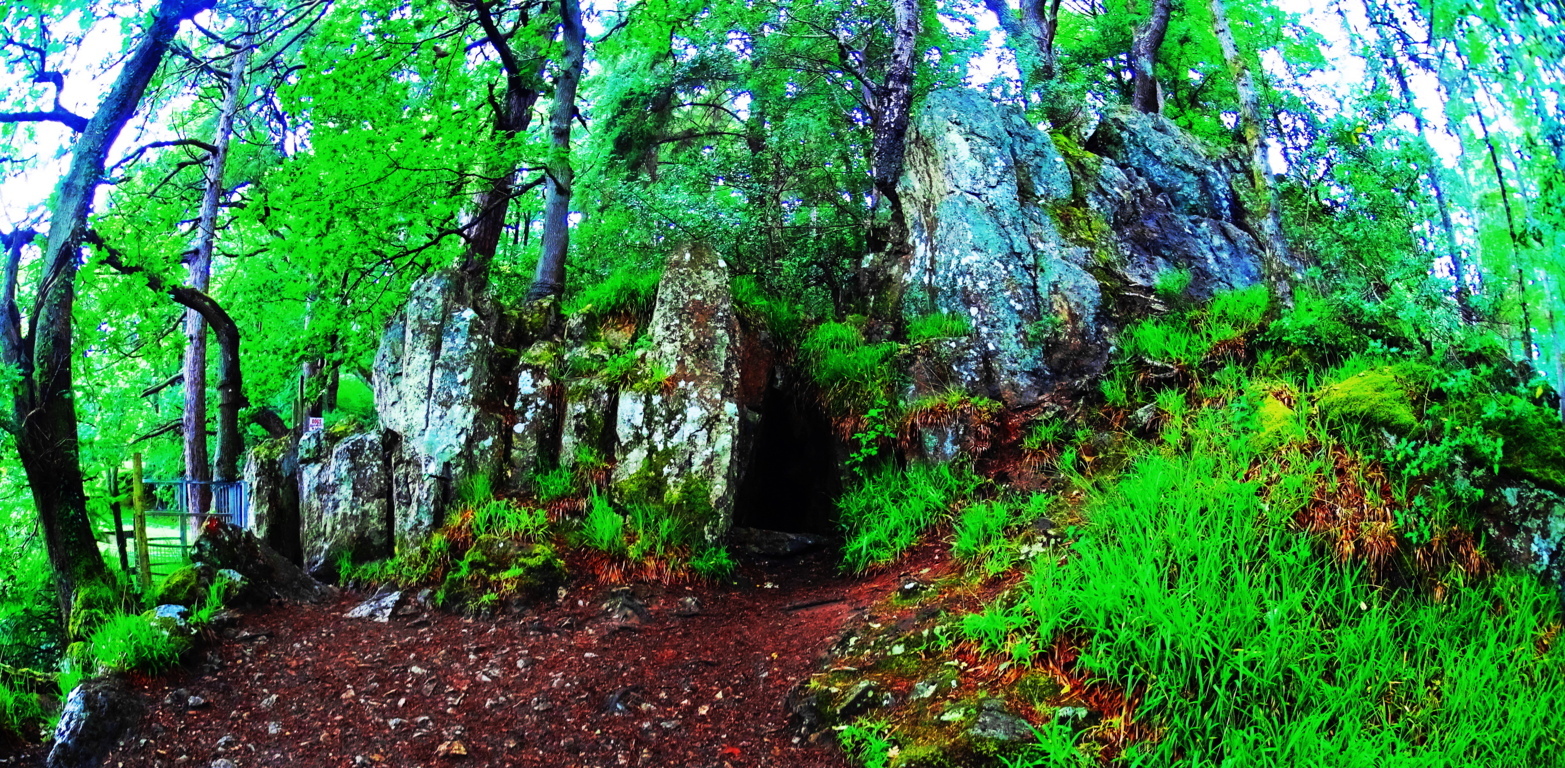 Ancient stone linings circa 4000 B.C.E appear by the river Avon, with regal Oak Tree’s spreading roots straight into the stream, and classic Celtic Fairy Foxgloves proudly peering through the ancient stones. The river Avon is lined with amazing free-standing boulders and cut-stones very similar to New England’s forests in Vermont and New Hampshire, across the Atlantic.
 Climbing along the run of the river is an adventure well worth exploring. When the sun comes out in Wales, it is hard to imagine wanting to be anywhere else in the world. Classic Celtic moss covers so much of the stone work, both on the river, and on land, indicating that it is ancient forestry. This creates a green glowing ‘halo’ over everything, like something out of the movie Excalibur. The forests reflect shafts of light through the trees, with an infinity of watery reflections and small spectrum flashes beaming in any photos you might take. Ten miles to the north is the stunning Conwy Valley, containing the timeless Mean Y Bradd Dolmen.
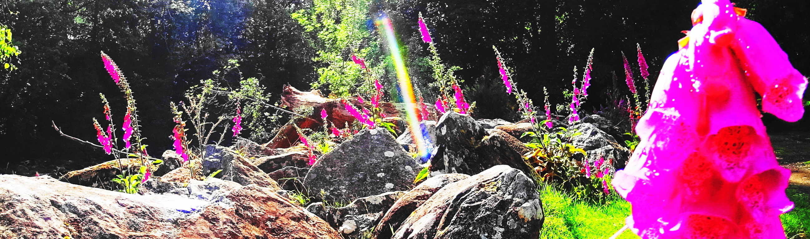 Seven miles to the north-west is the legendary Pen Y Pass, with trails that run all the way up to Mount Snowdon’s peak. The community at Betws Y Coed is bustling with hikers, climbers, Kayak enthusiasts, and campers, all enthusiastic to experience and share adventures. More generally, Wales is the legendary retreat of the band Led Zeppelin, and the inspiration for some of the best acoustic-blend rock-and-roll of all time.
 Revered author J.R.R Tolkien also stayed in Wales during the writing of The Lord of The Rings in the 1940’s, and was clearly influenced by it’s riveting beauty.
 The Lord of The Rings, through that beauty, has sold over 100 million copies world wide. If Wales is a place you wish to explore, think about staying in Betws Y Coed; 100 million readers can’t be wrong.:)
Killarney National Park
 Location: Killarney, Ireland
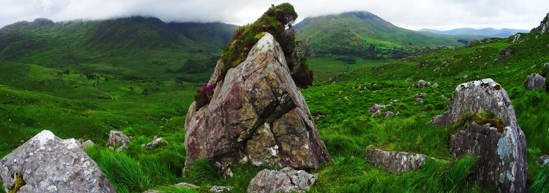
Note: In the presently modern condition the world finds itself in, filled with expanding urbanization in gentrifying cities across the globe, Killarney stands out as the ultimate Celtic haven, forever resisting through the sheer force of it’s natural beauty. Killarney is a dark Celtic fantasy, draped in jade, mingled with enchanted heights and mountain Gaps, where slanted stones literally hold coded messages of a Celtic era gone by.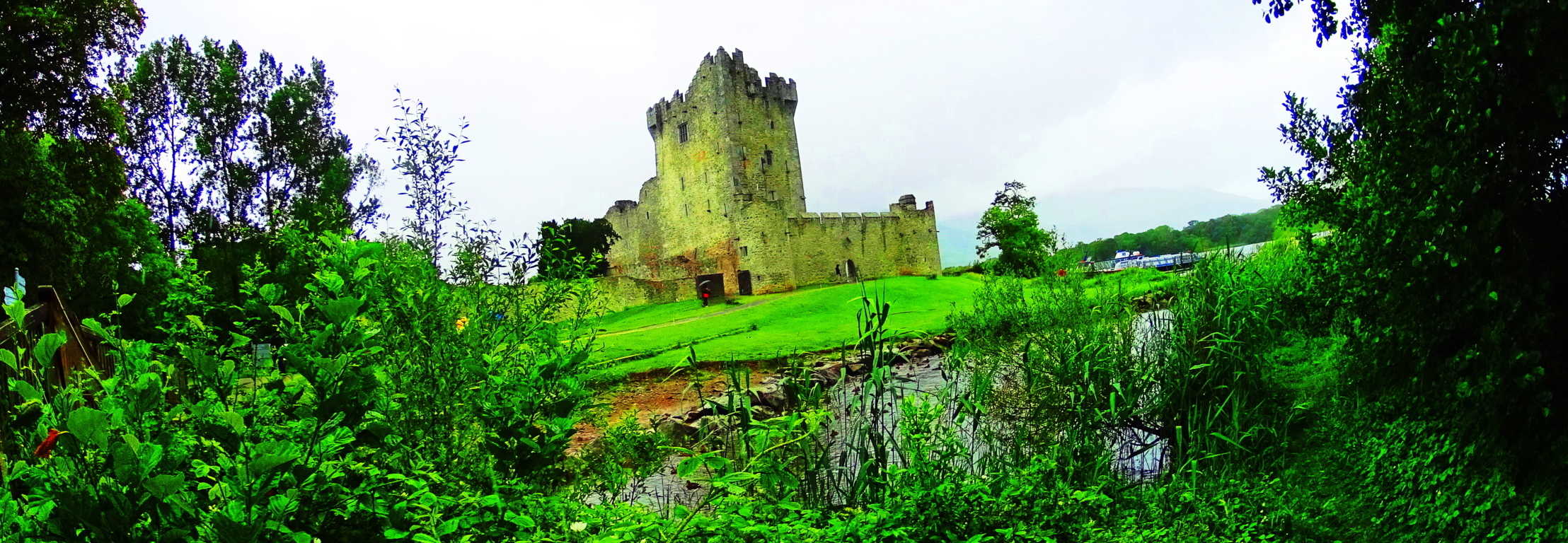 The view from the mountain peaks just south of Moll’s Gap is a hiker’s dream (top image), where you will need to gear-up in steel-tipped boots and a rain resistant windbreaker to truly enjoy the climb. Here the options are endless. Perhaps following a waterfall up a mountain sounds appealing. The angled stones of these long rivulets look to have been cut long ago, in order to influence the flow of the water.
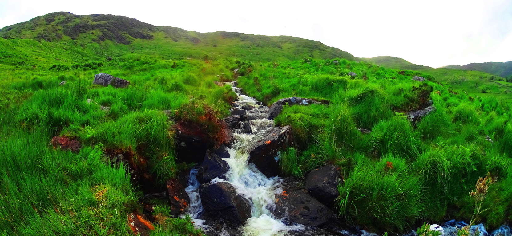 This is similar to many streams in New England and Scotland, where the landscapes appear to have been engineered in antiquity. Just one of hundreds of enchanting and mysterious features Killarney provides. The winding solitary dirt-roads far below have no names, but are known to be a portion of the majestic Ring of Kerry, where mountain biking is ideal.
 To the north is the crystalline Lake Brinn. Monumental slabs in the heights along the road headed to Moll”s Gap align to this lake, forever memorializing it as one of the best vantages in the world. These squared slabs of solid granite are a half mile above the road, and contain concentric rings that were carved into its face, representing a smooth contemplative perfection that is anything but primitive. These are priceless Celtic symbols.
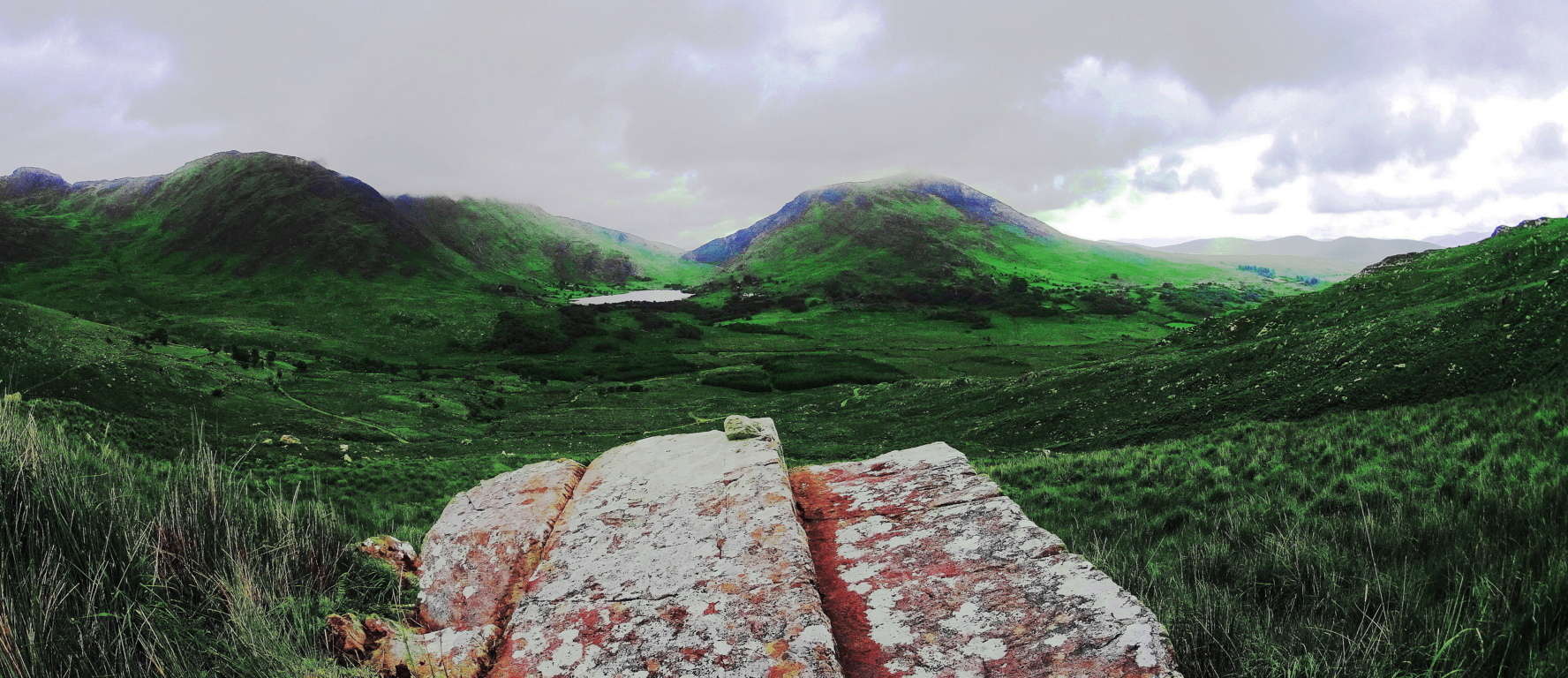 Moments in places where the concentric rings are crafted into the stones take on an almost Zen quality, the places photographers sacrifice to reach.
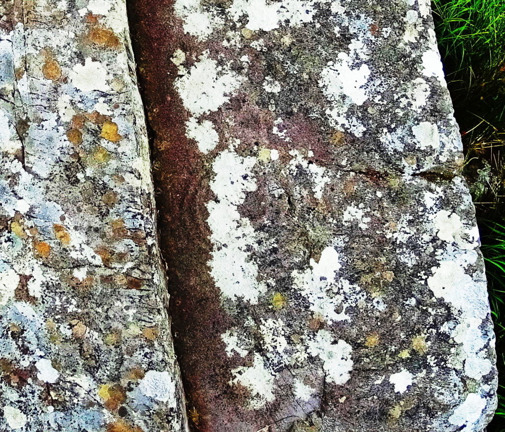 When you find these rare sacred spots you share the beauty of the moment with those who marked it and gave it significance so long ago. You connect all the way to the beginning of Time. Further to the north more features of the landscape emerge, as well as more regulated hiking opportunities. Torc Waterfall is the largest Fall in Killarney.
 It’s a gorgeous cascade of falling water drifting down over massive boulders. A marked trail runs beside the fall, and up the beautifully forested mountain, for roughly two miles of elevated hiking. Above the Fall is a phenomenal view of Muckross and Leane Lakes, as well Ross Castle further to the north. The castle, built in the 15th century, is the centerpiece for several hiking trails that run to the west, through Ross Woods. There are several loops to choose from that run for miles through Celtic glades that are absolutely enchanting. Some of the rarer trees look to be 500 years in growth or more, seemingly from an entirely different era, and of a type I had never seen before.
 Every winding road and path in Killarney is a potential hiking experience. This is a place where looking over a map at night and planning the following days excursion to various Gaps, trails, and mountains is a true joy. For those who love epic drives, Killarney is a prize winner. By car you can arrive at several of the captivating vistas that Killarney is known for, such as Ladies View (pictured below), the Gap of Dunloe, or dozens of stops along the road to the Black Valley, at the southern edge of the Reserve. In so many of the still pockets of the park a deer may appear, as this delicate fawn did just west of the N71 road. (Bottom Image)
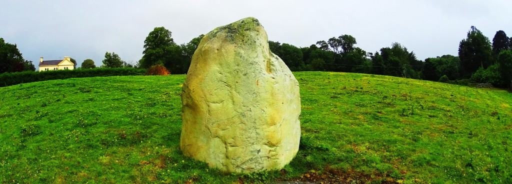
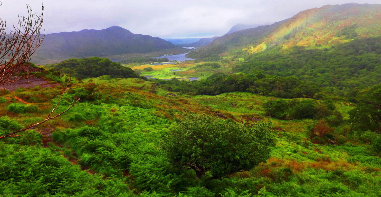 Killarney is a venerable Celtic Valhalla for hikers, mountain bikers, cinematographers, dreamers, and naturalists, looking to tap into the best of what natures elements and energies have to offer. Killarney is not the sunny paradise of flighty escapist entertainments that so many western vacationers understandably seek out, but rather, it is an incredibly deep and often times dark Celtic dimension, full of rustic challenges and blue-grey breezes that end in otherworldly vantages. Just south of Killarney Town on the N71 road that runs through the park is a beautiful Standing Stone. It is yet another example of what megaliths often indicate, silently but strongly, that the area you are about to enter is a true wonderland.
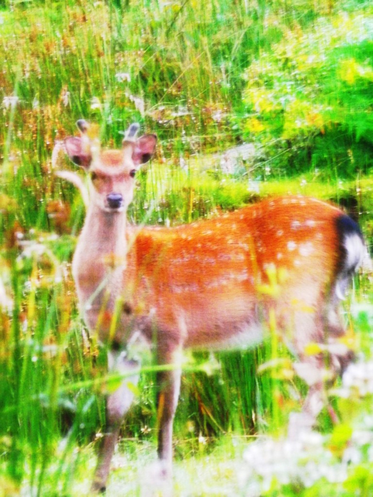
Kinnitty Forest
 Location: Kinnitty, Ireland
Elevation: 1,729 feet
Note: If you wanted to find the geographical heart of all Ireland, working your way towards the absolute center of the country, you would inevitably arrive at the beautiful medieval town of Kinnitty. After just a momentary glimpse of this landscape it truly seems as if the countryside itself has become aware of it’s central placement as the green-beating-heart of Ireland, producing a stellar Celtic scene absolutely worthy of this title. Kinnitty Mountain, along with the old forest that runs along it’s lower valley, sits just a half mile to the north-west of tranquil Kinnitty. Hikers can pick up the main trail into this gorgeous scene at one of the prettiest entry points in the world, behind Kinnitty Castle, built in the year 1209. The Castle remains fully functional, with fine dining, an accessible outer courtyard, and stables where horses are kept and trained on the mountain throughout the day.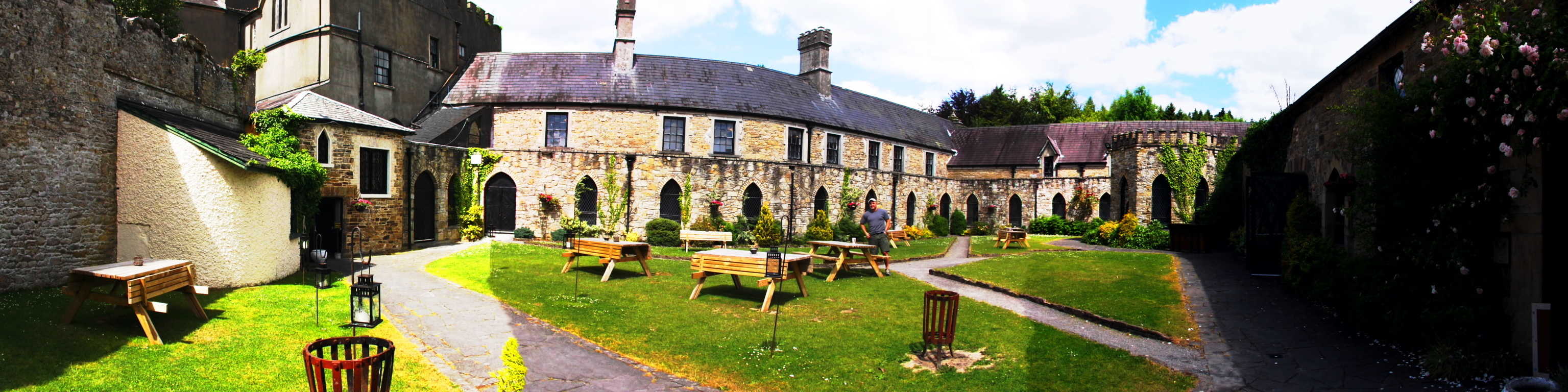 Headed towards the trail it feels as if you’ve walked into an epic fable, or a medieval saga. The trail begins just behind the stables beyond a small trickling stream. A stone-circle will appear on your right, just 20 yards away from the path. It is a picturesque scene, with a barn-house at the edge of the looming Wood.
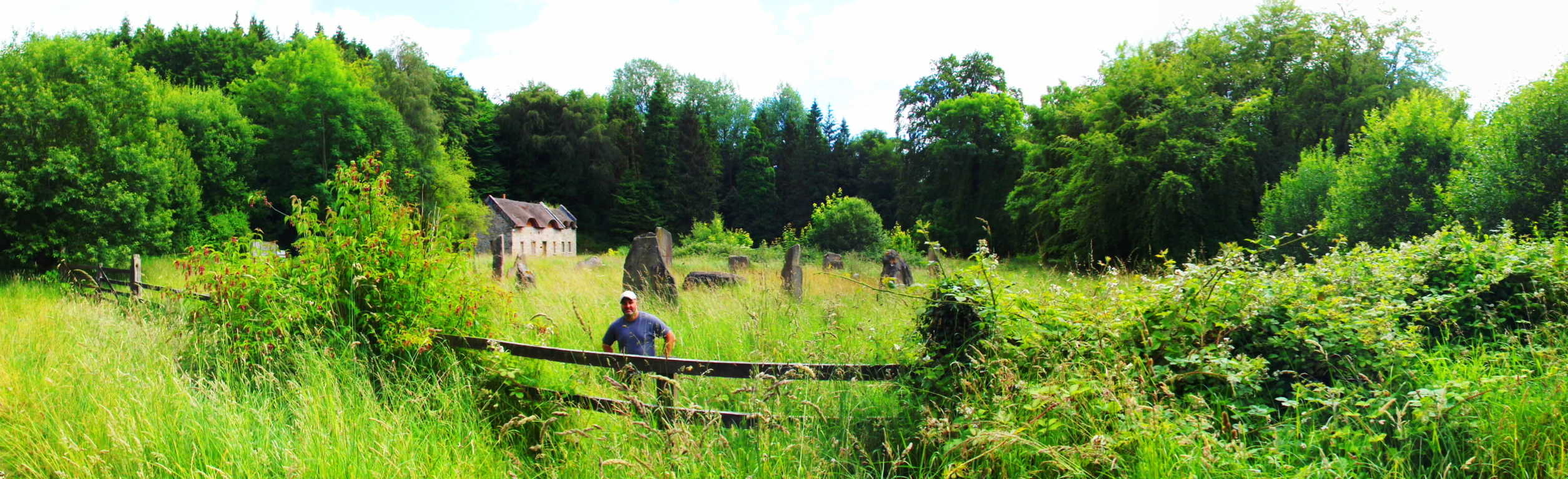 Unfortunately, the stone circle is not authentic, and was created by a previous owner of the estate some years ago, but it’s aesthetic effect is certainly complimentary.
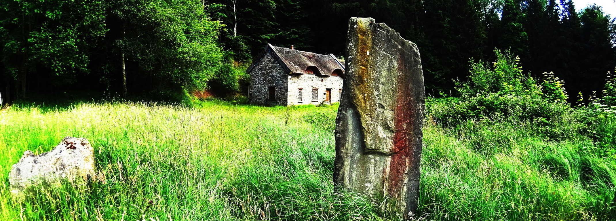 Continuing past the sign that reads ‘Kinnitty Forest’ just beyond the circle, the trail begins to climb. With the British incursion of Ireland beginning in the 12th century, the British Royals illustrious Navy and it’s ships, as well the occupying manors and hamlets abroad, which were built in support of the Crowns `expansion’, deforested Ireland almost entirely.
 The upside to to this is that the remaining trees that make up Kinnitty Forest are like the regal survivors of a once beautiful era, refusing to vanish.
 They loom over the trail protectively with a beautiful bright milky color that shines against the glades. Continuing above the tree line, the trail begins to circle the Mountain, just to the right. In the open air and Sun, Fairy Foxgloves and Clovers appear in bright clusters. If you look down, at an elevation of roughly 1600 feet, in the most landlocked trail in all of Ireland, you will discover Seashells mingled with the stones!.
 How these shells came to rest at the top of a mountain is just one of many wonderful discussions you might have while strolling through this fantastic Celtic scene. The loop continues for roughly 4.5 miles before returning to the Castle grounds. There are alternate trails that continue several miles to the north-east, into the Sleive Bloom Mountain Range, if you wish to continue the experience. Kinnitty Forest trail is truly the sacred heart of all Ireland, and in every possible way. It is a priceless glimpse into the way things once were, of a quieter more peaceful time that still lingers in the hills of this Celtic place. It is my hope that whoever reads this review, and takes it to heart, will one day experience it for themselves.
Pen-Y-Pass
 Location: Gwynedd, Snowdonia/Wales
Note: About 10 miles south east of Mount Snowdon , tucked behind rocky passes and elevated clear-water lakes, is the wonderfully serene and scenic ‘Pen-Y-Pass’. With wide trails wrapping around massive mossy basins and jagged rocky caverns, this cinematic trail will carry you all the way to the peak of Snowdon if you so choose, following a north westerly course. Along the way waterfalls cut the mountainsides and streams trickle in the distance. This is a classic Celtic scene, with a minimal amount of forestry, but a wonderful collage of every shade of green imaginable.
 Reeds drift in the wind, blended with moss and grass on huge knolls and hills that roll, and roll again, in every distant direction. In the heights above cut-boulders and grand shafts of granite slice dramatic angles into the peaks.
 In the valley below, for those who have the eyes to see, are ancient Celtic alters dug into the landscape; Circular stone Cairns with centerpieces that are so old they seem to be almost consumed by the earth, sitting eternally in wait to be rediscovered.
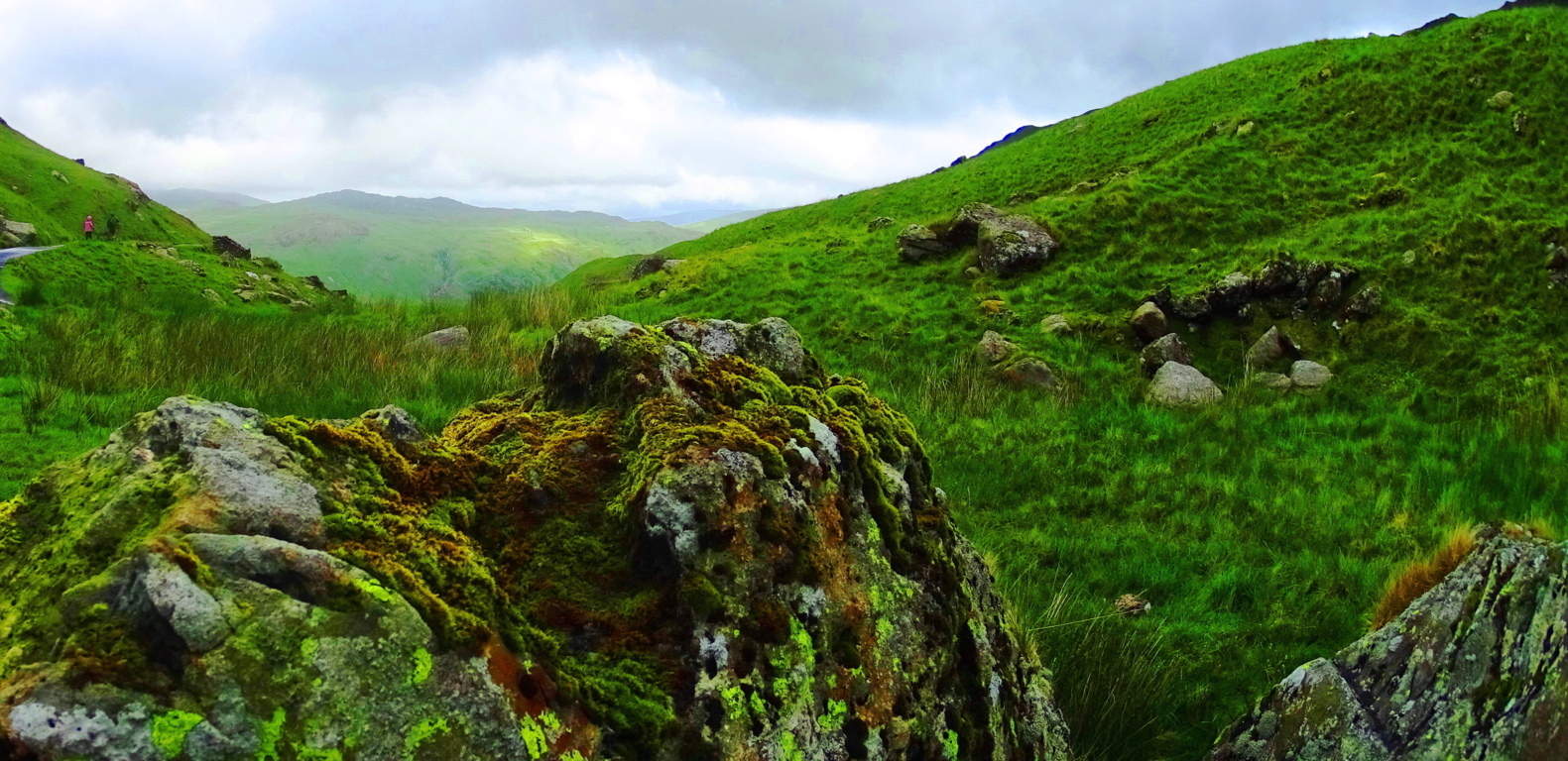 Circular stone alters with centering fixtures of very similar style exist in the forest of Foxboro Massachusetts, although there, they are covered by an ocean of foliage, and equally hard to decipher
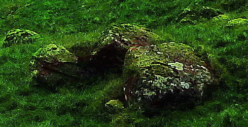
 (An example of the circular alter is shown below, white granite and quartz stones covered by the classic red/orange leaves of New England trails/Please click on photos to look closer). Another wonderful feature of Pen-Y-Pass are the old stone dwellings, most likely of the medieval period, that have been long since abandoned by herdsman and farmers for lack of resources in the valley. The hills of this landscape are huge,
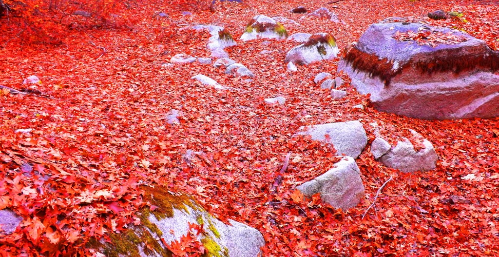
 with entire sections quarried out and abandoned. Some portions of the quarrying look to have been carried out perhaps no more than five hundred years ago, with less growth upon it, while other massive stones are completely grown over with moss, as if it were done perhaps thousands of years ago. Perhaps Pen-Y-Pass’s most shining quality is the feeling there. The air, when the weather is agreeable, is comfortably cool and clear. Everything you see: mountain, lake, hill, valley, look to be cut from the sky by a diamond. There is an echo in the soft and subtle movements of rams, water, and distant trailblazers.
 The car-park for this trail is just off the A4086 highway. If you ever come through this valley, do yourself a fantastic favor and plan at least one day to walk the timeless Celtic trail at Pen-Y-Pass, it just shouldn’t be missed.
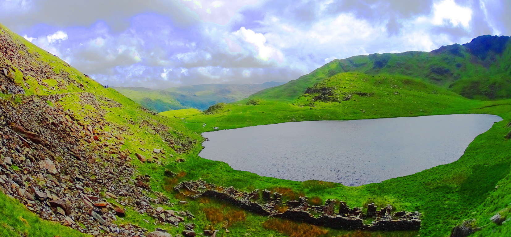
Lynn Woods Trail/Secret Megaliths
 Location: Lynn Woods/Massachusetts/North West of Boston
Lynn Woods/Long Piece

Ireland/Long Piece
The beautiful trails at Lynn Woods are roughly 8 miles of preserved old forestry, centered around a crystal-blue lake. The small but exquisite area is surrounded by the little city of Lynn, north-west of Boston. Paths run along the lake to the east, or west into the forest, where after roughly 2.5 miles of elevated trail, a scenic stone tower appears on top of the most significant elevation in the reserve. Mountain bikers, dog-lovers, and runners utilize the area to the fullest in the Summer, continuing well into the Fall, when the trees begin to glow a luminary red, yellow, and orange. Bright Birch groves emerge with swaying Maple’s and Pines that reflect off the water while trekking along.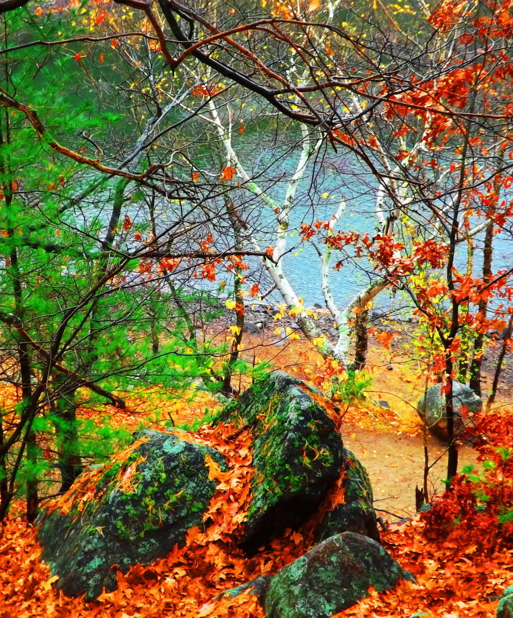 Anyone visiting this particular area of Massachusetts looking not to venture too far from Boston, but wanting to experience quintessential New England fauna and foliage, should hike right into Lynn Woods for a picturesque day. Although signs are posted for patrons to stay on the trail, there is an abundance of anthropological statements in the beautiful stone fixtures deep in the woods, and along the lake waterline. A careful and experienced hiker can certainly take the time to appreciate some of these incredible stone fixtures that host markings with measurement styles and stone types similar to those found in the Celtic heights of the mountains of Donegal Ireland, making them potentially 4000 to 6000 years old. A marvelous long piece sits close to the water at the start of the eastern trail, among other cut stones with distinct markings. The measurements on this long piece reveal 9 spaces of smaller cuts between the longer cuts: a system based on 11 spaces as a ‘full span’. The colonial ‘foot; is not represented in these works. A fantastic crafted boulder sits just off the eastern trail directly along the waterline. It displays an enigmatic 45* degree set of linear incisions running directly across the face of the rock.
 Interestingly enough, Lynn Woods is a also home to the largest Standing Stone in Massachusetts, found just a half mile into the very beginning of the trail from the parking area: take an immediate left after walking the short distance, an climb to the very top of the hill, just outside of the woods, and you will find the Standing Stone.
 It is beautifully set standing roughly 11 feet high and 3 feet in width. I am guessing that this stone weighs at least 5 tons. Similar to many Celtic standing stones, there is a second smaller stone that was obviously cut off from the main standing piece, ‘smaller’ meaning it weighs about 900 pounds or so. It sits eternally just to the left of the megalith. For real antiquarians, in the deeper forest, there are free standing boulders and massive megalithic fixtures on the top of the rolling hills continuing away from the lake.
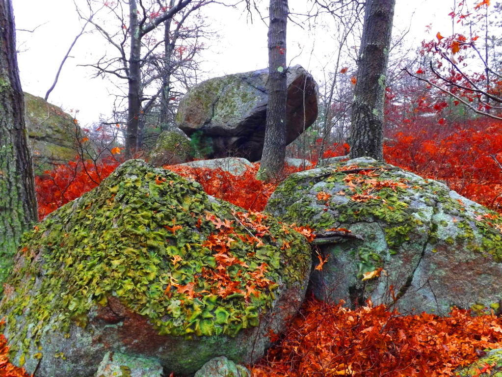 One of the most amazing pieces in all of New England is 4 miles into the eastern trail, just to the right of the path. This massive 20 ton granite stone stands 8 feet high, and is an incredible display of precision made parallel cuts, and measuring metrics. The stone is incised through nothing less than four full feet of solid granite rock. There are mathematical statements in this stone still to be deciphered, and it is truly priceless. When considering the megaliths of Lynn Woods it has to transcend the simple label of ‘nature reserve’. Lynn Woods makes the roll of Stonestrider.com due to these obviously sacred statements of megalithic expressions, so similar to the Celtic world, making it extremely likely that they are from deep antiquity. Unfortunately, all of these stones are not even noted in New England anthropological society, until now; Yet if they were in Ireland, England, Wales, or Scotland, they would be revered and protected. This place is one of the best kept anthropological secrets in all of New England.
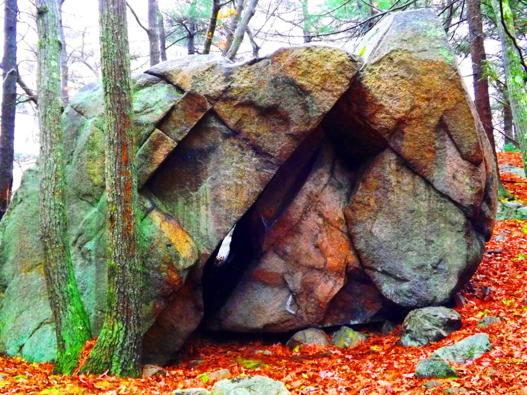
Tully Lake/Forest of Neolithic Engineering
 Location: Athol Massachusetts
Ireland
Tully Lake
Note: Tully Lake Trail is nothing less than a kingdom of cut stones enveloped by gorgeous old growth forest in the heart of New England. The main trail loops down along the lake for about two miles, and then back into the elevated forest for another five. It is a challenging hike in winter, but enchanting. As you begin to progress into the glades of tall pines, birch, and maple, it becomes impossible to ignore the crafted megaliths lining the hillsides. It becomes abundantly clear that whoever engineered these incredible stones wanted them to be noticed. It is a venerable masonic work area, with standing stones, cut boulders, stone linings, and ancient stone dwellings. Furthermore, the stonework is not arbitrarily placed, but is clearly set in a specific manner, although beneath a blanket of snow it is difficult to decipher on a blustery December day. The clarity of the markings on these stones is astonishing. Similar styles of measurement for the cutting of megaliths exist at Mount Bearnagh in the Mourne Range of Ireland, and also most notably in the Lynn Woods further east of here in Massachusetts. Observing the scale of what are clearly measurement markings for cutting, (which I must add is certainly not inches, but some other grand standard) allows us to consider what the craftsman of the stones considered to be ‘scale’.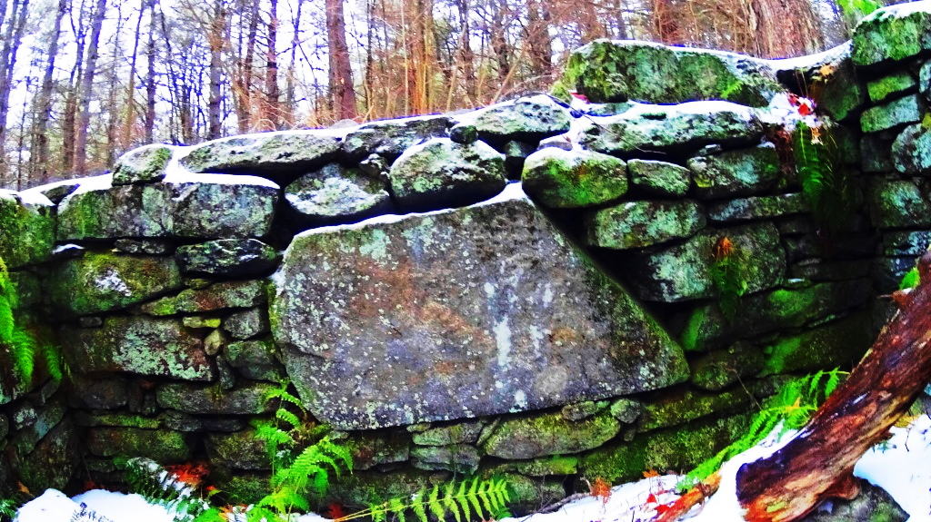 And that scale is MASSIVE. The stones also reveal incredibly complicated curvatures, extremely hard to create in large granite pieces.
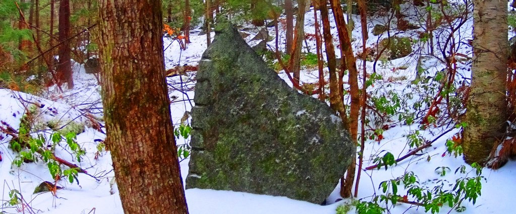 The entire forest is inundated with stone statements that cry out for observation. Consistent with other old-growth trails all over the world, this forest contains the remnants of what I believe is the one time home of the craftsman of this area. Sitting roughly four miles into the loop of the main trail, unlabelled in any way, to the right of the pathway while heading back towards the entrance, I saw an incredible stone foundation of what was once clearly someones home. This site featured a beautifully dry-laid and grand cut-stone looking to weigh at least 2 tons, embedded perfectly into the foundation. The amount of care and effort that went into placing just this one megalithic center-piece must have been challenging. With sites like this, a trail becomes a priceless anthropological zone on the level of Tollymore Forest in Ireland, and Monument Mountain in the southern Berkshires of Massachusetts.
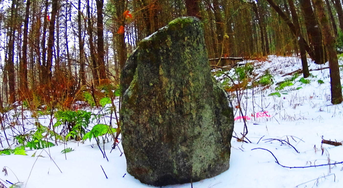 To find an ancient dwelling, or one definitive standing stone in a single New England forest is rare, but to find several is truly exhilarating. Further along the trail there is a stone connected to a stone-lining (‘wall’) looking very much like a Celtic ‘directional stone’, almost identical to types I have seen in England.
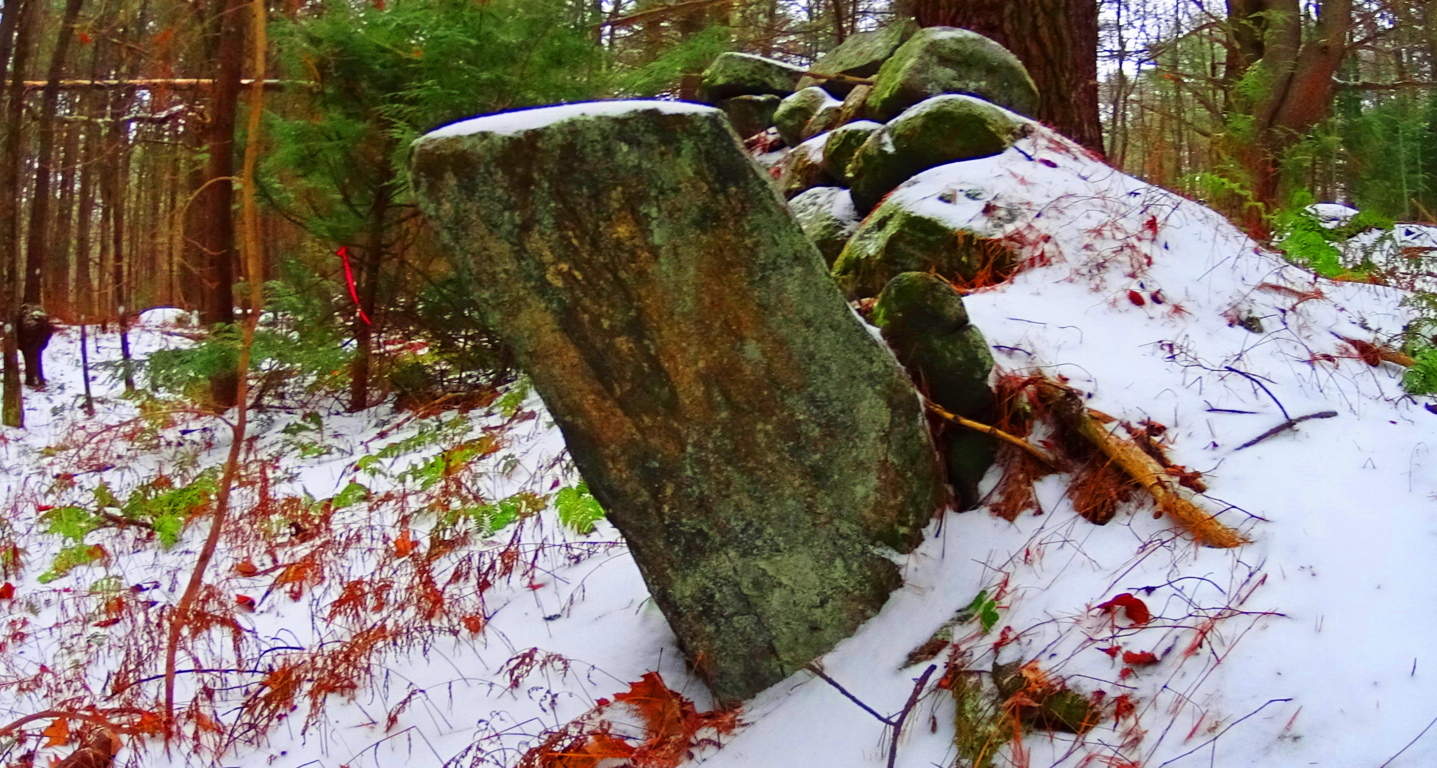 Celtic areas have preserved these stones and properly noted them as important anthropological statements from a culture perhaps 6000 years in the past, but New England has failed to do so here. Ironically, this somehow makes New England’s ancient sites feel a bit more pristine than even Celtic areas that are well known, because the stones have not been touched, or even visited by anyone knowingly seeking the works of a neolithic culture. When considering that almost every massive boulder in the forest contains some form of crafting, whether it be boulders split in half, or simply marked by incisions of some type, the amount of energy that would have been put into this effort is astounding, and so worth noting. And all the time, behind fixture after fixture of colossal craftsmanship, is mile upon mile of zig-zagging stone linings sliding through the trees.
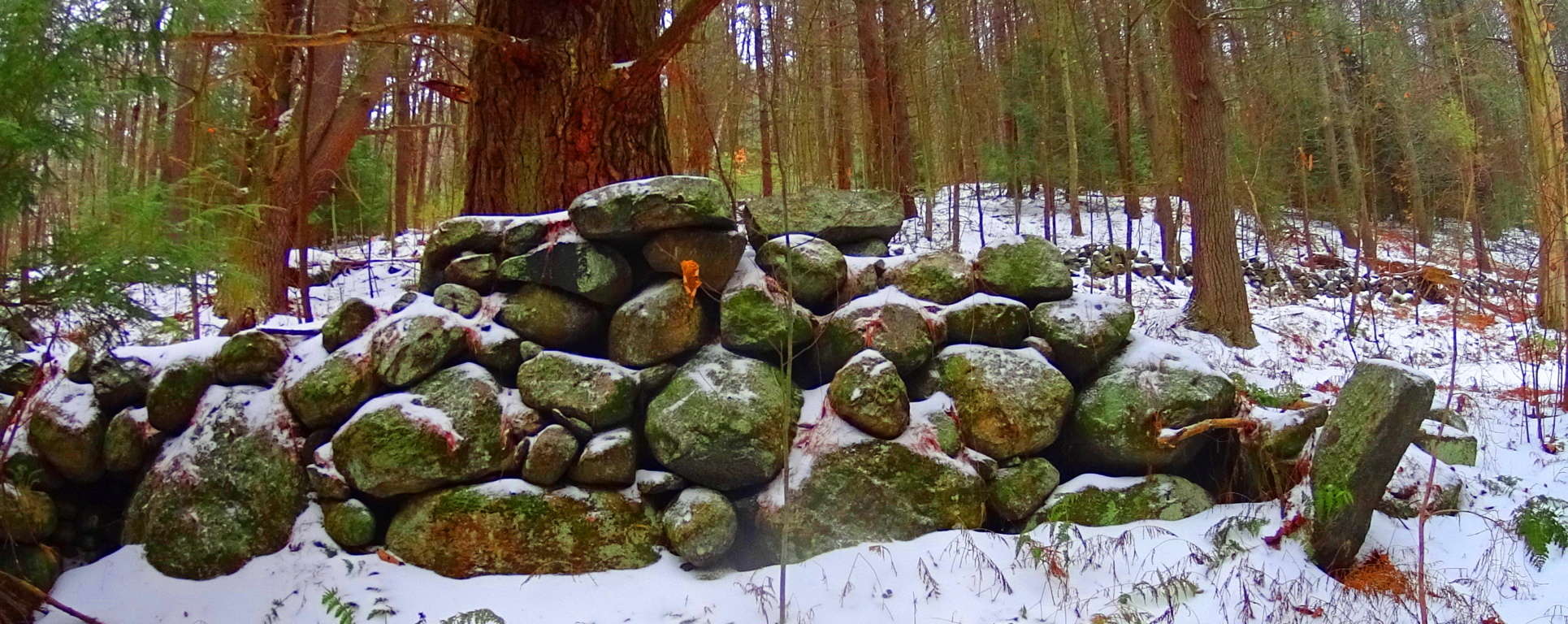 Close consideration of these works reveal that these efforts are not mere random ‘holes’ in the rock, but linearly lined incisions.
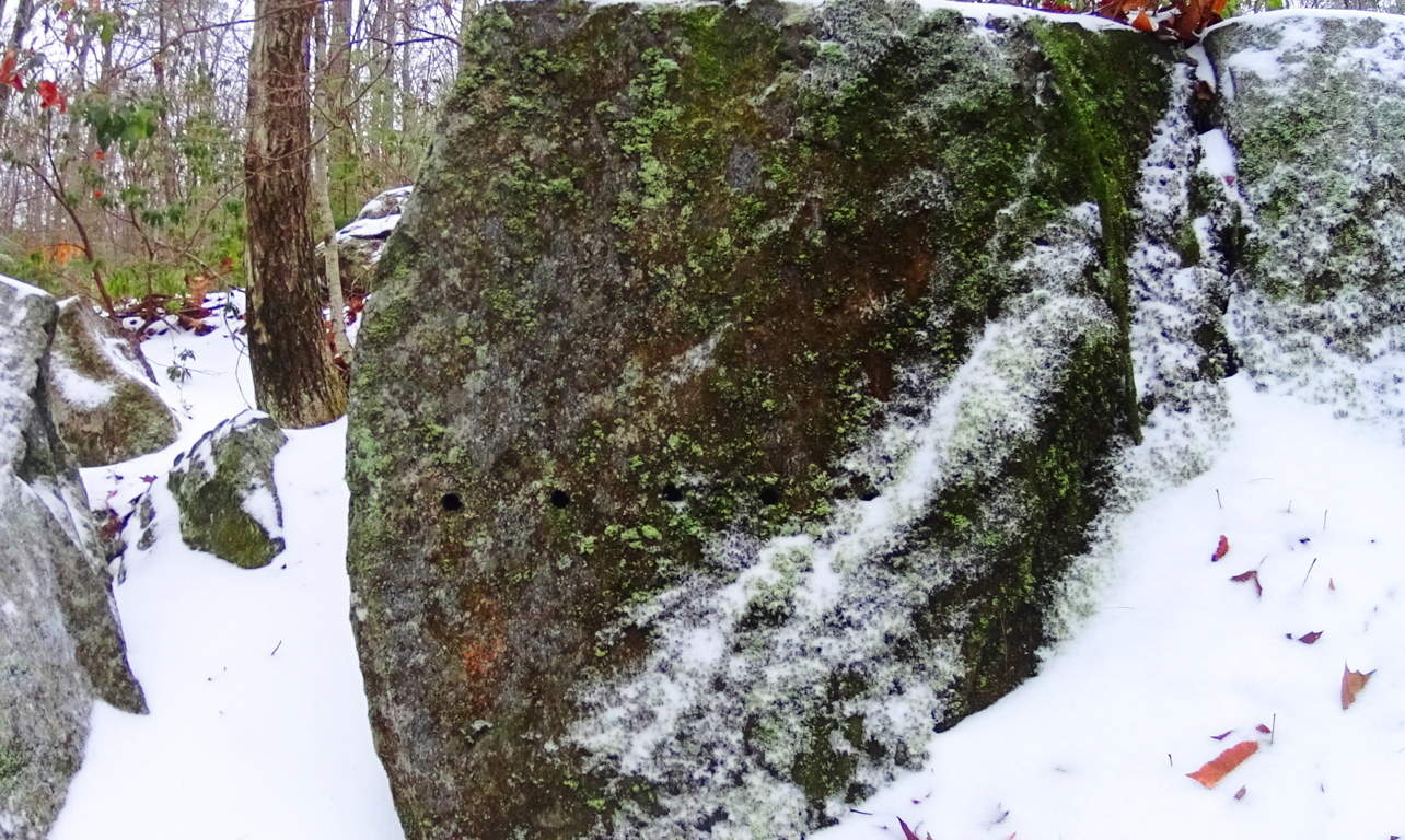 And cuts along the edges of these megaliths are measurements, not random markings. Some of the craft work is truly artistic, revealing a joy in the artistry. Some stones are set in pairs, others are laid out as massive fixtures, seeming to have a functional flare. Hiking through these pathways is a pure wonder that pushes the boundaries of our understanding of what might have taken place clear back to the beginning of Time.
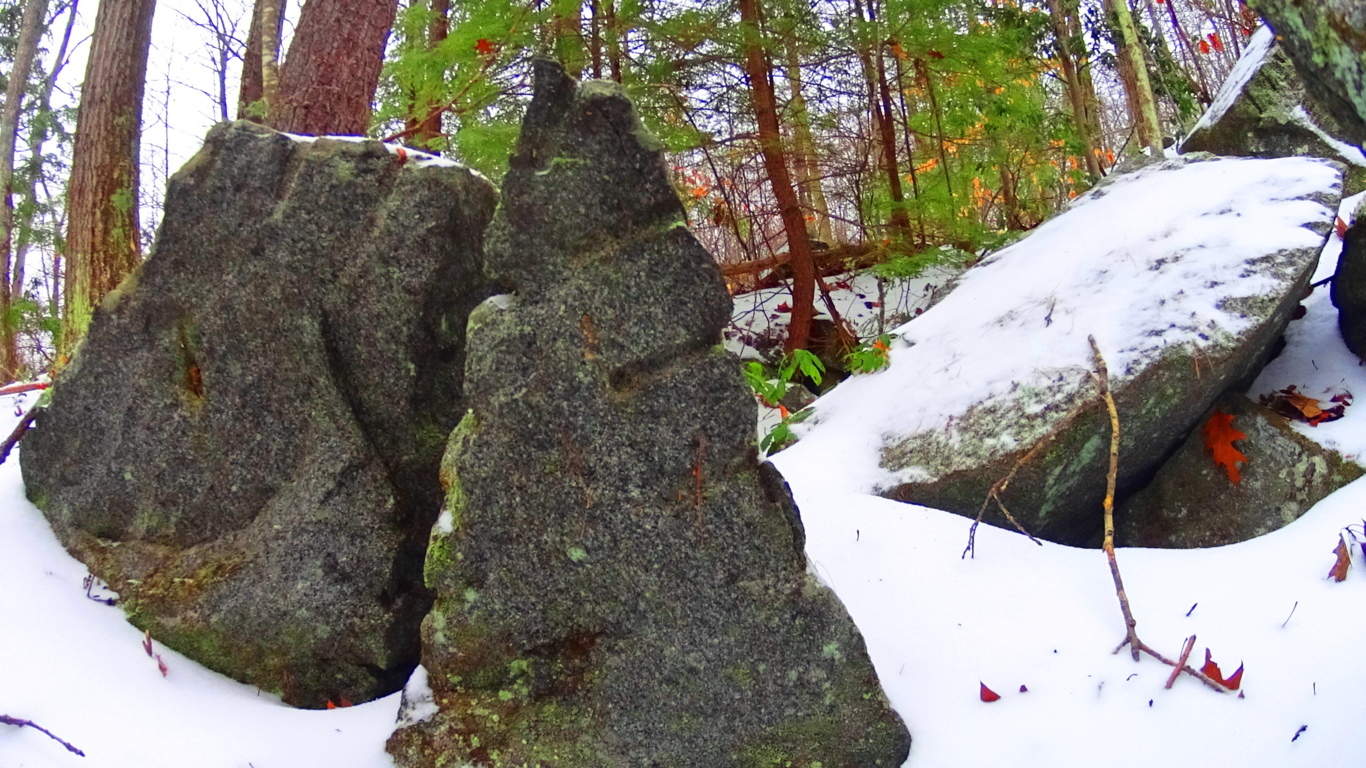 The stones themselves seem to insist that it may not be the linear evolutionary line that postmodern texts have been pushing for the last 100 years. It is clear that technology existed in antiquity, and was utilized in this incredible daydream of a forest. On an international scale of 1 to 10 for sacred forests, Tully Lake is a 15. Seek and find it out for yourself, something truly magical took place here.
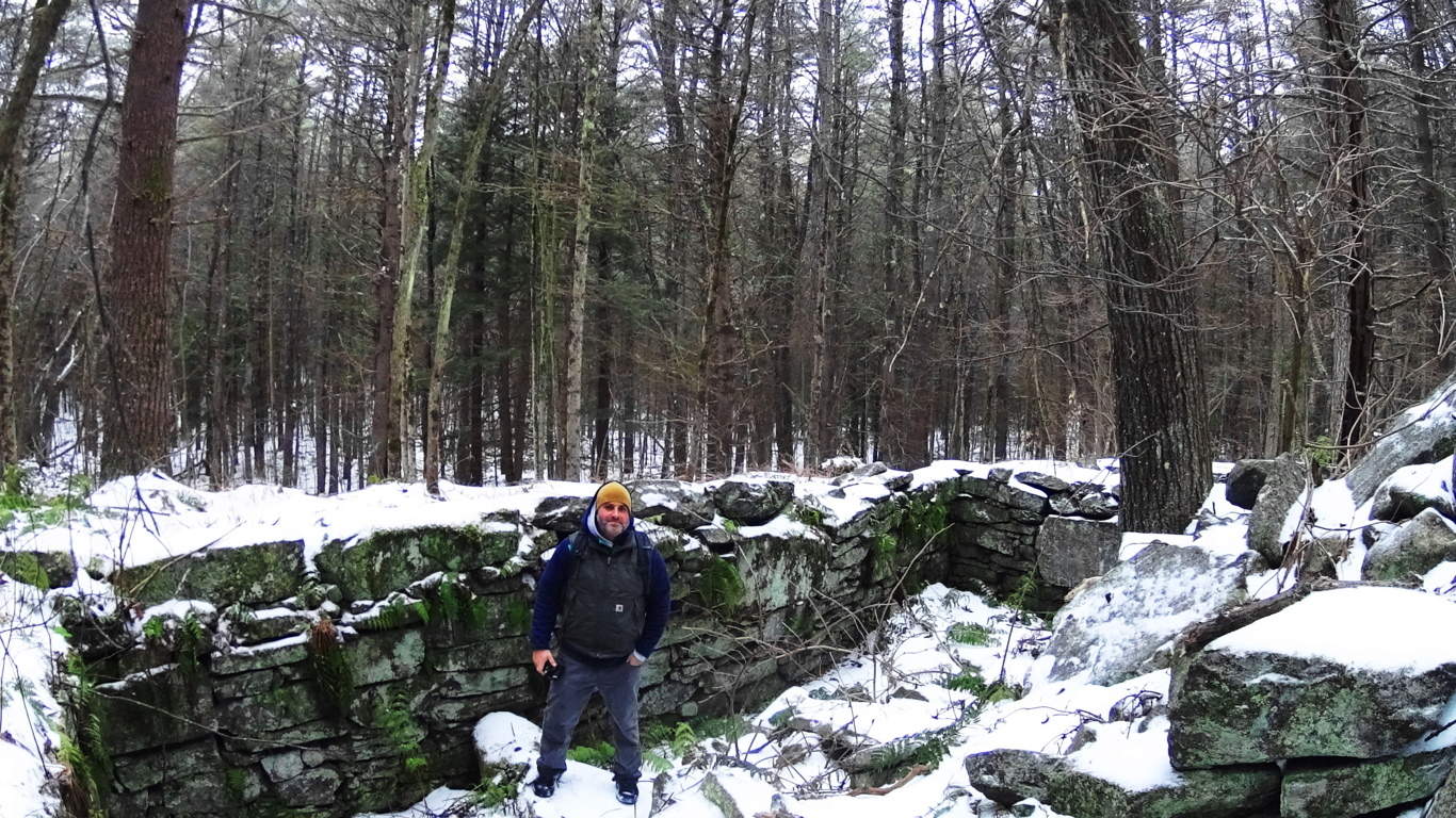
Cavan Burren National Park (Part 1: Celtic Altar)
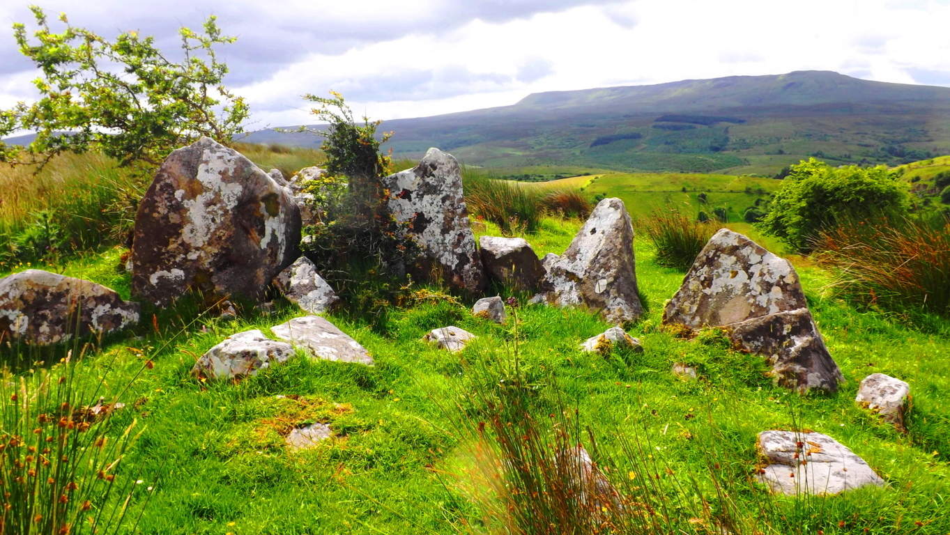 Location: Blacklion/County Cavan Ireland/Cavan Burren National Park
Note: If the quintessential Celtic ‘dreamscape’ is what you are hoping to find in a hiking experience, Cavan Burren National Park is the place for you.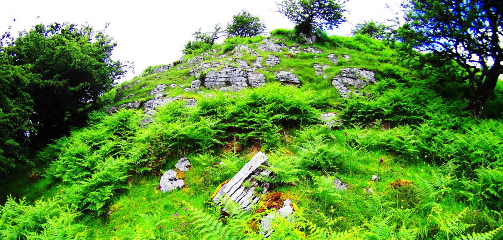 This pristine pre-history landscape is sacred on every possible level, with roughly ten square miles of Celtic wildlife preserve. Embedded in the surreal panoramic vistas surrounding Cuilcagh Mountain, on which the park is mainly canvased, are priceless 5000 year old Wedge Tombs, Alters, Dolmens, and megaliths. A fantastic trail runs from the main entrance/visitors-center of the park to beautiful anthropological sites. The area is absolutely worthy of several specified reviews for each of the sites along this main route, but the real wonder of the region, and perhaps it’s most establishing distinction as a truly Celtic reserve for both exquisitely rare natural fauna and neolithic cultural gems, is that the off trail hiking reveals supremely beautiful works of ancient stone engineering as well. I discovered this incredible alter, featured in the title image above, by interpreting the lay of the engineered stones expressed over the landscape. Postmodern anthropologists have taken a dismissively poor perspective on what they have lazily identified as “farmers walls” looping over the hillsides. These “farmers walls” are not “walls” at all; functionally they do not limit the movements of grazing flocks in any way. Herds can simply walk over these stones if they so choose, so by literal definition, it is not a wall. The function of these special stones that look to our modern eyes as “walling” is actually a type of primitive ‘cable system’ that connects each sacred alter, from one to the next.
 These stone linings are like the wire that runs between a battery’s charge points, to the base-tip of a light bulb, passing energy from one end-point of energy to the next. I found this alter by following the lined stones running north west off the main trail.
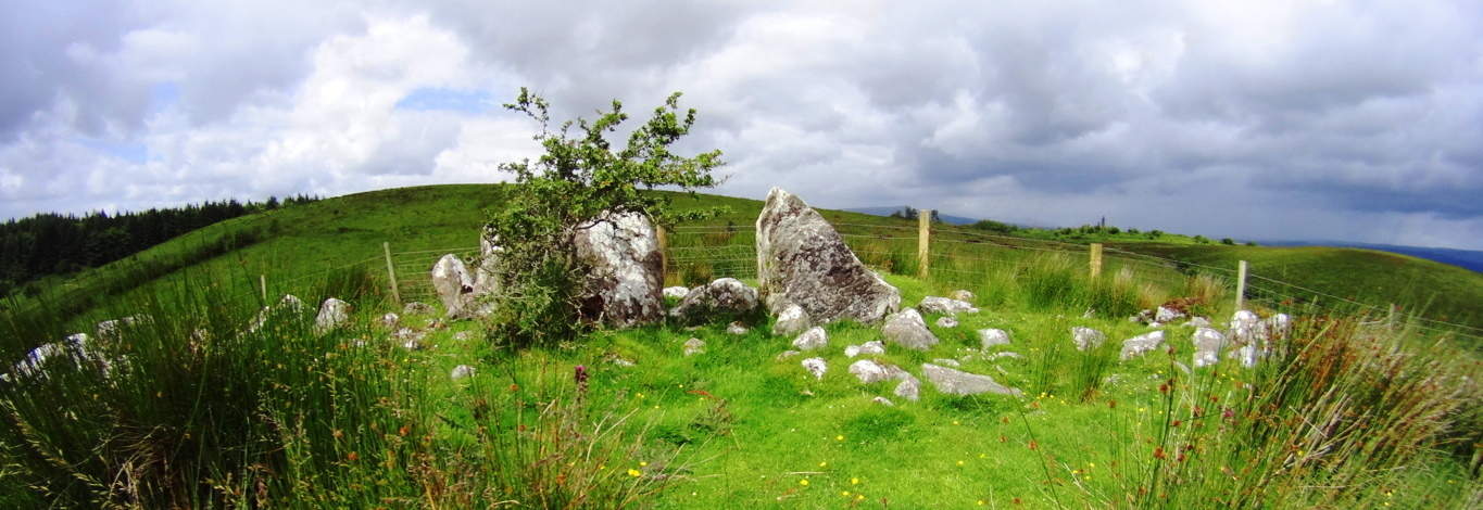 My educated guess was therefore to follow the lined stones I observed to see what special feature it was connected to. I arrived at this incredible Celtic alter wonderfully positioned at the next hilltop, approximately 1.5 miles northwest of the main trails (Top Image).
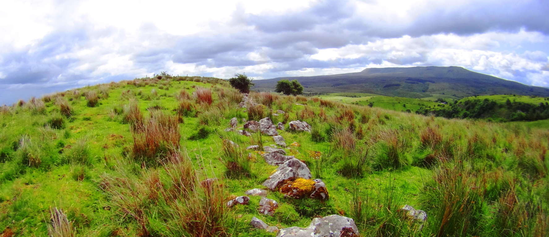 Here again was another moment where my firm belief in the premise of engineered landscapes was vindicated. The earliest Celtic cultures attempted to harness and designate the transfer of energy in the landscape with stones that absorb the energy from the sun and connect the alters sitting strategically at the top the hills. These lined stones funneled energy from peak to peak, alter to alter. Most modern anthropologists fall victim to assuming that a ‘defined sacred space’ requires a specific ‘central temple’ that celebrates the area in a basically singular declaration. What they refuse to consider is that an even higher expression of the sacredness of the landscape is of course to utilize it while celebrating it, making the entire area a type of living, functional temple which connects each elevated corner. This engineering is also present in the mountains and forests of New England. I encourage hikers to prepare appropriate gear for deeply experiencing the landscape, for trekking into wilder corners of the reserves. If you follow the stone-linings of ancient Celtic zones to areas away from the designated trail, you will soon find that the premise of engineered landscapes is absolutely real. Aside form this, the natural beauty of the area is stellar. To deeply experience any ancient landscape equip yourself with cinema-capable cameras and capture your trek.
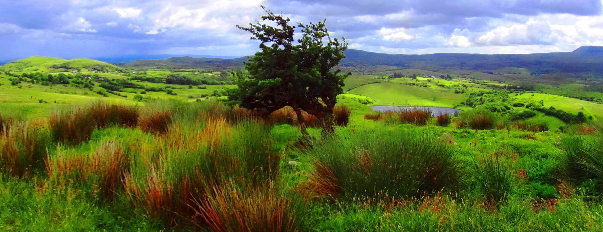 Cavan Burren National Park is a portal into the primordial era of the earths most fantastic expressions, with priceless anthropological expressions of engineering from the first culture on earth. Seek, and find it out for yourself.